Property Record
560 Hollis Lakes Rd, Rock Hill, SC 29732

This Property Is For Sale
NEARBY LISTINGS FOR SALE OR LEASE
Property Detail
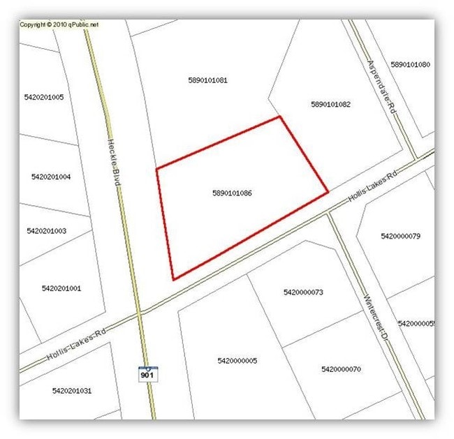
560 Hollis Lakes Rd
5890101086
CORNER OF HECKLE&HOLLIS 1.768
Commercialacreage
York
X
South Carolina
45091C0304F
1.77 AC
2025
York County
2025
Charlotte
060909
Charlotte-Concord-Gastonia, NC-SC
DEMOGRAPHICS near 560 Hollis Lakes Rd
1 Mile
3 Mile
5 Mile
2024 Total Population
4,163
38,201
93,960
2029 Population
4,648
42,722
105,447
Pop Growth 2024-2029
+ 11.65%
+ 11.83%
+ 12.23%
Average Age
40
42
40
2024 Total Households
1,713
15,505
37,459
HH Growth 2024-2029
+ 12.03%
+ 12.13%
+ 12.81%
Median Household Inc
$95,615
$72,170
$63,154
Avg Household Size
2.40
2.40
2.40
2024 Avg HH Vehicles
2.00
2.00
2.00
Median Home Value
$256,849
$261,662
$240,505
Median Year Built
2000
1994
1991
Nearby Places
Map Layers
Map Styles
 Street
 Aerial
- Restaurants
- Banks
- Shops
- Fitness
- Groceries
PUBLIC TRANSPORTATION
AIRPORT
Charlotte/Douglas International
DRIVE
WALK
Distance
Charlotte/Douglas International
42 min
24.4 mi
Freight Ports
North Charleston Terminal
DRIVE
WALK
Distance
North Charleston Terminal
205 min
179.4 mi
Nearby Properties
Address
Land Use
TOTAL SIZE
Lot Size
Zoning
Address
Land Use
TOTAL SIZE
Lot Size
Zoning
13,556 SF
10.86 AC
MF15
Address
Land Use
TOTAL SIZE
Lot Size
Zoning
45,426 SF
6 AC
MF15
Address
Land Use
TOTAL SIZE
Lot Size
Zoning
28,848 SF
1.04 AC
PUD
Address
Land Use
TOTAL SIZE
Lot Size
Zoning
10,232 SF
4.50 AC
MF15
Address
Land Use
TOTAL SIZE
Lot Size
Zoning
554,100 SF
21.58 AC
OI
Address
Land Use
TOTAL SIZE
Lot Size
Zoning
28,320 SF
2.67 AC
IG
Address
Land Use
TOTAL SIZE
Lot Size
Zoning
8,348 SF
1 AC
SF3
Address
Land Use
TOTAL SIZE
Lot Size
Zoning
14,178 SF
1.81 AC
OI
Address
Land Use
TOTAL SIZE
Lot Size
Zoning
38,000 SF
4.28 AC
LC
Address
Land Use
TOTAL SIZE
Lot Size
Zoning
23,898 SF
19.65 AC
OI
Address
Land Use
TOTAL SIZE
Lot Size
Zoning
1,254 SF
108.90 AC
RDI
Address
Land Use
TOTAL SIZE
Lot Size
Zoning
Address
Land Use
TOTAL SIZE
Lot Size
Zoning
176,736 SF
23.29 AC
RDI
Address
Land Use
TOTAL SIZE
Lot Size
Zoning
4,449 SF
1.52 AC
MF15
Address
Land Use
TOTAL SIZE
Lot Size
Zoning
9,116 SF
0.74 AC
PUDO
Address
Land Use
TOTAL SIZE
Lot Size
Zoning
11.76 AC
PUD
Address
Land Use
TOTAL SIZE
Lot Size
Zoning
26,001 SF
9.76 AC
PUD
Address
Land Use
TOTAL SIZE
Lot Size
Zoning
4,421 SF
1 AC
SF3
Address
Land Use
TOTAL SIZE
Lot Size
Zoning
112,905 SF
4.24 AC
NMU
Address
Land Use
TOTAL SIZE
Lot Size
Zoning
20,304 SF
19 AC
LC
Address
Land Use
TOTAL SIZE
Lot Size
Zoning
4,794 SF
1 AC
SF3
Address
Land Use
TOTAL SIZE
Lot Size
Zoning
4,660 SF
0.70 AC
SF3
Address
Land Use
TOTAL SIZE
Lot Size
Zoning
3,865 SF
0.61 AC
MF15
Address
Land Use
TOTAL SIZE
Lot Size
Zoning
40,176 SF
4.62 AC
NO
Address
Land Use
TOTAL SIZE
Lot Size
Zoning
3,864 SF
2.20 AC
RDI
Address
Land Use
TOTAL SIZE
Lot Size
Zoning
4,561 SF
1 AC
SF3
Address
Land Use
TOTAL SIZE
Lot Size
Zoning
56.57 AC
BDIII
Address
Land Use
TOTAL SIZE
Lot Size
Zoning
6,375 SF
8.24 AC
SF5
Address
Land Use
TOTAL SIZE
Lot Size
Zoning
4,655 SF
1 AC
SF3
Address
Land Use
TOTAL SIZE
Lot Size
Zoning
135,186 SF
9.27 AC
The World's #1 Commercial Real Estate Marketplace
Connect with us
© 2026 CoStar Group
The information above has been obtained from sources believed reliable. While we do not doubt its accuracy we have not verified it and make no guarantee, warranty or representation about it. It is your responsibility to independently confirm its accuracy and completeness. Any projections, opinions, assumptions, or estimates used are for example only and do not represent the current or future performance of the property. The value of this transaction to you depends on tax and other factors which should be evaluated by your tax, financial, and legal advisors. You and your advisors should conduct a careful, independent investigation of the property to determine to your satisfaction the suitability of the property for your needs.