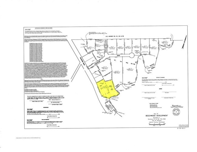
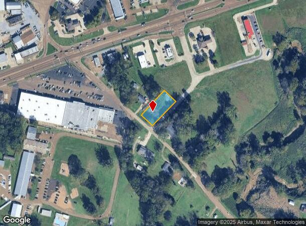
Property Record
13 N Palestine Rd, Natchez, MS 39120
NEARBY LISTINGS FOR SALE OR LEASE
Property Detail
13 N Palestine Rd
Natchez, MS-LA
Adams
0085-0001-0009
Mississippi
Sfr
0.54 AC
X
Hattiesburg/South Area
28001C0190D
Other Market Areas
2,215 SF
DEMOGRAPHICS near 13 N Palestine Rd
1 Mile
3 Mile
5 Mile
2024 Total Population
3,055
15,325
22,580
2029 Population
2,906
14,654
21,538
Pop Growth 2024-2029
(4.88%)
(4.38%)
(4.61%)
Average Age
40
42
43
2024 Total Households
1,311
6,908
10,020
HH Growth 2024-2029
(4.65%)
(4.13%)
(4.41%)
Median Household Inc
$26,755
$30,024
$32,936
Avg Household Size
2.20
2.20
2.20
2024 Avg HH Vehicles
1.00
2.00
2.00
Median Home Value
$72,055
$84,610
$96,233
Median Year Built
1970
1964
1965
Nearby Places
- Restaurants
- Banks
- Shops
- Fitness
- Groceries
SALE & LEASE HISTORY
LISTING DATE
SALE/LEASE

Sep 06, 2017
For Sale
Mar 05, 2019
For Sale
Nearby Properties
Address
Land Use
TOTAL SIZE
Lot Size
Zoning
Address
Land Use
TOTAL SIZE
Lot Size
Zoning
91.24 AC
RVR
Address
Land Use
TOTAL SIZE
Lot Size
Zoning
178,600 SF
25 AC
B4
Address
Land Use
TOTAL SIZE
Lot Size
Zoning
1,080 SF
145 AC
SUD
Address
Land Use
TOTAL SIZE
Lot Size
Zoning
24,725 SF
1.10 AC
R4
Address
Land Use
TOTAL SIZE
Lot Size
Zoning
45,354 SF
1.17 AC
B3
Address
Land Use
TOTAL SIZE
Lot Size
Zoning
3,360 SF
18 AC
Address
Land Use
TOTAL SIZE
Lot Size
Zoning
11,684 SF
4.77 AC
B4
Address
Land Use
TOTAL SIZE
Lot Size
Zoning
11.10 AC
R4
Address
Land Use
TOTAL SIZE
Lot Size
Zoning
92,765 SF
6.36 AC
B4
Address
Land Use
TOTAL SIZE
Lot Size
Zoning
19,370 SF
0.89 AC
B3
Address
Land Use
TOTAL SIZE
Lot Size
Zoning
7,847 SF
4 AC
Address
Land Use
TOTAL SIZE
Lot Size
Zoning
2,426 SF
10.49 AC
R4
Address
Land Use
TOTAL SIZE
Lot Size
Zoning
27,570 SF
7.62 AC
B1
Address
Land Use
TOTAL SIZE
Lot Size
Zoning
4,514 SF
13.50 AC
R4
Address
Land Use
TOTAL SIZE
Lot Size
Zoning
11,694 SF
0.46 AC
B4
Address
Land Use
TOTAL SIZE
Lot Size
Zoning
11.33 AC
R4
Address
Land Use
TOTAL SIZE
Lot Size
Zoning
21,242 SF
5.48 AC
SUD
Address
Land Use
TOTAL SIZE
Lot Size
Zoning
2,624 SF
35 AC
R-2
Address
Land Use
TOTAL SIZE
Lot Size
Zoning
19,320 SF
9 AC
B4
Address
Land Use
TOTAL SIZE
Lot Size
Zoning
2,075 SF
6.79 AC
B4
Address
Land Use
TOTAL SIZE
Lot Size
Zoning
3,465 SF
6.40 AC
R3
Address
Land Use
TOTAL SIZE
Lot Size
Zoning
68,750 SF
6.32 AC
Address
Land Use
TOTAL SIZE
Lot Size
Zoning
14,985 SF
1.74 AC
B4
Address
Land Use
TOTAL SIZE
Lot Size
Zoning
7,821 SF
13.25 AC
R4
Address
Land Use
TOTAL SIZE
Lot Size
Zoning
28,569 SF
2.89 AC
B4
Address
Land Use
TOTAL SIZE
Lot Size
Zoning
20,656 SF
3.76 AC
B4
Address
Land Use
TOTAL SIZE
Lot Size
Zoning
5,736 SF
10 AC
Address
Land Use
TOTAL SIZE
Lot Size
Zoning
7,168 SF
0.46 AC
B2
Address
Land Use
TOTAL SIZE
Lot Size
Zoning
18,788 SF
3.07 AC
Address
Land Use
TOTAL SIZE
Lot Size
Zoning
4,297 SF
1.38 AC
B4
The World's #1 Commercial Real Estate Marketplace
Connect with us
© 2025 CoStar Group
The information above has been obtained from sources believed reliable. While we do not doubt its accuracy we have not verified it and make no guarantee, warranty or representation about it. It is your responsibility to independently confirm its accuracy and completeness. Any projections, opinions, assumptions, or estimates used are for example only and do not represent the current or future performance of the property. The value of this transaction to you depends on tax and other factors which should be evaluated by your tax, financial, and legal advisors. You and your advisors should conduct a careful, independent investigation of the property to determine to your satisfaction the suitability of the property for your needs.