Property Record
Hendrix Ave, Northport, AL 35475
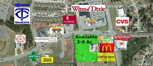

NEARBY LISTINGS FOR SALE OR LEASE
-
-
View all Northport listings for sale on LoopNet.com
Property Detail
Hendrix Ave
Tuscaloosa, AL
Hendrix Addition S/D
20-04-17-0-002-002.004
COM NE COR LOT 1 HENDRIX ADDITION S/D IN S17 T20S R10W; E 50; S 311(S); E 260(S); SE 22(S); W 370(S); N 320(S) TO POB
Vacantlandnec
Tuscaloosa
X
Alabama
01125C0336G
1
2025
0.42 AC
2024
Tuscaloosa
010203
Birmingham
DEMOGRAPHICS near Hendrix Ave
1 Mile
3 Mile
5 Mile
2024 Total Population
3,179
12,828
32,702
2029 Population
3,427
13,967
36,251
Pop Growth 2024-2029
+ 7.80%
+ 8.88%
+ 10.85%
Average Age
37
38
41
2024 Total Households
1,143
4,739
12,282
HH Growth 2024-2029
+ 7.61%
+ 8.86%
+ 10.82%
Median Household Inc
$96,213
$97,340
$89,415
Avg Household Size
2.80
2.70
2.50
2024 Avg HH Vehicles
2.00
2.00
2.00
Median Home Value
$234,748
$267,304
$246,542
Median Year Built
1999
2000
1995
Nearby Places
Map Layers
Map Styles
 Street
 Aerial
- Restaurants
- Banks
- Shops
- Fitness
- Groceries
PUBLIC TRANSPORTATION
COMMUTER RAIL
Tuscaloosa Amtrak Station (Crescent - Amtrak)
DRIVE
WALK
Distance
Tuscaloosa Amtrak Station (Crescent - Amtrak)
14 min
8.9 mi
Freight Ports
Port of Mobile
DRIVE
WALK
Distance
Port of Mobile
250 min
207.7 mi
SALE & LEASE HISTORY
LISTING DATE
SALE/LEASE

Sep 24, 2016
For Sale
Mar 15, 2017
For Lease
Jul 23, 2018
For Sale
Nearby Properties
Address
Land Use
TOTAL SIZE
Lot Size
Zoning
Address
Land Use
TOTAL SIZE
Lot Size
Zoning
4,210 SF
15 AC
RS-SD
Address
Land Use
TOTAL SIZE
Lot Size
Zoning
52,852 SF
10.21 AC
C-3
Address
Land Use
TOTAL SIZE
Lot Size
Zoning
47,657 SF
9.53 AC
C-3
Address
Land Use
TOTAL SIZE
Lot Size
Zoning
37,553 SF
12 AC
O-I
Address
Land Use
TOTAL SIZE
Lot Size
Zoning
4,306 SF
4.60 AC
OI
Address
Land Use
TOTAL SIZE
Lot Size
Zoning
25,451 SF
4.32 AC
C-3
Address
Land Use
TOTAL SIZE
Lot Size
Zoning
5,504 SF
14 AC
Address
Land Use
TOTAL SIZE
Lot Size
Zoning
2,500 SF
160.39 AC
Address
Land Use
TOTAL SIZE
Lot Size
Zoning
30,000 SF
5.85 AC
Address
Land Use
TOTAL SIZE
Lot Size
Zoning
25,662 SF
4.09 AC
C3
Address
Land Use
TOTAL SIZE
Lot Size
Zoning
13,775 SF
2.60 AC
C-3
Address
Land Use
TOTAL SIZE
Lot Size
Zoning
12,000 SF
4.28 AC
Address
Land Use
TOTAL SIZE
Lot Size
Zoning
10,486 SF
2.43 AC
C-3
Address
Land Use
TOTAL SIZE
Lot Size
Zoning
21,711 SF
6.10 AC
Address
Land Use
TOTAL SIZE
Lot Size
Zoning
5,760 SF
8.40 AC
Address
Land Use
TOTAL SIZE
Lot Size
Zoning
4,873 SF
3 AC
C-3
Address
Land Use
TOTAL SIZE
Lot Size
Zoning
12,500 SF
0.60 AC
Address
Land Use
TOTAL SIZE
Lot Size
Zoning
11,760 SF
2.33 AC
Address
Land Use
TOTAL SIZE
Lot Size
Zoning
5,922 SF
1.04 AC
Address
Land Use
TOTAL SIZE
Lot Size
Zoning
3,486 SF
2 AC
C-3
Address
Land Use
TOTAL SIZE
Lot Size
Zoning
2,500 SF
6.20 AC
Address
Land Use
TOTAL SIZE
Lot Size
Zoning
3,311 SF
1.20 AC
C-3
Address
Land Use
TOTAL SIZE
Lot Size
Zoning
120 SF
3.02 AC
Address
Land Use
TOTAL SIZE
Lot Size
Zoning
4,426 SF
28.60 AC
Address
Land Use
TOTAL SIZE
Lot Size
Zoning
13,832 SF
3.98 AC
Address
Land Use
TOTAL SIZE
Lot Size
Zoning
10,000 SF
3.99 AC
Address
Land Use
TOTAL SIZE
Lot Size
Zoning
7,700 SF
1.20 AC
Address
Land Use
TOTAL SIZE
Lot Size
Zoning
2,680 SF
1.12 AC
C-2
Address
Land Use
TOTAL SIZE
Lot Size
Zoning
135 AC
Address
Land Use
TOTAL SIZE
Lot Size
Zoning
500 SF
1.77 AC
The World's #1 Commercial Real Estate Marketplace
Connect with us
© 2025 CoStar Group
The information above has been obtained from sources believed reliable. While we do not doubt its accuracy we have not verified it and make no guarantee, warranty or representation about it. It is your responsibility to independently confirm its accuracy and completeness. Any projections, opinions, assumptions, or estimates used are for example only and do not represent the current or future performance of the property. The value of this transaction to you depends on tax and other factors which should be evaluated by your tax, financial, and legal advisors. You and your advisors should conduct a careful, independent investigation of the property to determine to your satisfaction the suitability of the property for your needs.