Property Record
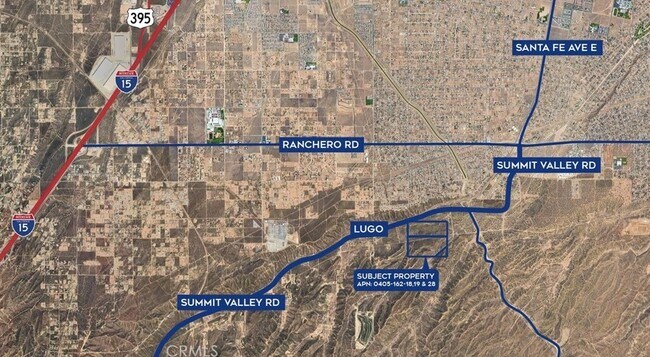
Hesperia Dump Rd, Hesperia, CA 92345

Property Detail
Hesperia Dump Rd
0405-162-18
N 1/2 NE 1/4 SEC 7 TP 3N R 4W EX N 330 FT 60 AC M/L
Vacantlandnec
SAN BERNARDINO
RS1
California
D Areas with possible but undetermined flood hazards.
73.22 AC
2025
Mojave River Valley
2025
Inland Empire (California)
010019
Riverside-San Bernardino-Ontario, CA
NEARBY LISTINGS FOR SALE OR LEASE
DEMOGRAPHICS near Hesperia Dump Rd
1 mile
3 mile
5 mile
2025 Total Population
2,214
17,925
69,038
2030 Population
2,231
18,211
70,238
Pop Growth 2025-2030
+ 0.77%
+ 1.60%
+ 1.74%
Average Age
37
38
36
2025 Total Households
646
5,187
20,217
HH Growth 2025-2030
+ 0.77%
+ 1.56%
+ 1.66%
Median Household Inc
$88,796
$83,376
$78,802
Avg Household Size
3.40
3.30
3.40
2025 Avg HH Vehicles
3.00
3.00
2.00
Median Home Value
$426,618
$452,802
$431,704
Median Year Built
1993
1990
1991
Nearby Places
Map Layers
Map Styles
 Street
 Aerial
Layers
 Traffic
 Biking
Places
Listings with unknown addresses are not visible on the map
- Restaurants
- Banks
- Shops
- Fitness
- Groceries
PUBLIC TRANSPORTATION
AIRPORT
Ontario International
Drive
Walk
Distance
Ontario International
56 min
37.0 mi
Freight Ports
Port of Long Beach
Drive
Walk
Distance
Port of Long Beach
118 min
89.1 mi
SALE & LEASE HISTORY
LISTING DATE
SALE/LEASE

Jan 13, 2020
For Sale
Dec 12, 2024
For Sale
Nearby Properties
Address
Land Use
TOTAL SIZE
Lot Size
Zoning
Address
Land Use
TOTAL SIZE
Lot Size
Zoning
8,095 SF
1.54 AC
Address
Land Use
TOTAL SIZE
Lot Size
Zoning
22,391 SF
1.33 AC
OHRL
Address
Land Use
TOTAL SIZE
Lot Size
Zoning
5,021 SF
0.90 AC
OHCN
Address
Land Use
TOTAL SIZE
Lot Size
Zoning
21,000 SF
3.53 AC
Address
Land Use
TOTAL SIZE
Lot Size
Zoning
13,938 SF
2.39 AC
OHCN
Address
Land Use
TOTAL SIZE
Lot Size
Zoning
4,500 SF
1.08 AC
Address
Land Use
TOTAL SIZE
Lot Size
Zoning
9.41 AC
Address
Land Use
TOTAL SIZE
Lot Size
Zoning
9.59 AC
Address
Land Use
TOTAL SIZE
Lot Size
Zoning
6,200 SF
2.78 AC
Address
Land Use
TOTAL SIZE
Lot Size
Zoning
8.32 AC
Address
Land Use
TOTAL SIZE
Lot Size
Zoning
7,494 SF
2.75 AC
Address
Land Use
TOTAL SIZE
Lot Size
Zoning
33,534 SF
2.53 AC
Address
Land Use
TOTAL SIZE
Lot Size
Zoning
2,312 SF
20 AC
OHRS1
Address
Land Use
TOTAL SIZE
Lot Size
Zoning
11,800 SF
1.01 AC
Address
Land Use
TOTAL SIZE
Lot Size
Zoning
2,240 SF
0.48 AC
OHRL
Address
Land Use
TOTAL SIZE
Lot Size
Zoning
6,148 SF
0.82 AC
OHCN
Address
Land Use
TOTAL SIZE
Lot Size
Zoning
9,745 SF
2.42 AC
Address
Land Use
TOTAL SIZE
Lot Size
Zoning
9,310 SF
1.26 AC
Address
Land Use
TOTAL SIZE
Lot Size
Zoning
3,106 SF
1.35 AC
Address
Land Use
TOTAL SIZE
Lot Size
Zoning
240 AC
RS1
Address
Land Use
TOTAL SIZE
Lot Size
Zoning
Address
Land Use
TOTAL SIZE
Lot Size
Zoning
4,842 SF
1.35 AC
Address
Land Use
TOTAL SIZE
Lot Size
Zoning
320 AC
RL10AP
Address
Land Use
TOTAL SIZE
Lot Size
Zoning
18.29 AC
Address
Land Use
TOTAL SIZE
Lot Size
Zoning
Address
Land Use
TOTAL SIZE
Lot Size
Zoning
2,762 SF
1.77 AC
OHRL
Address
Land Use
TOTAL SIZE
Lot Size
Zoning
2.29 AC
Address
Land Use
TOTAL SIZE
Lot Size
Zoning
2,804 SF
0.22 AC
The World's #1 Commercial Real Estate Marketplace
Connect with us
© 2026 CoStar Group
The information above has been obtained from sources believed reliable. While we do not doubt its accuracy we have not verified it and make no guarantee, warranty or representation about it. It is your responsibility to independently confirm its accuracy and completeness. Any projections, opinions, assumptions, or estimates used are for example only and do not represent the current or future performance of the property. The value of this transaction to you depends on tax and other factors which should be evaluated by your tax, financial, and legal advisors. You and your advisors should conduct a careful, independent investigation of the property to determine to your satisfaction the suitability of the property for your needs.