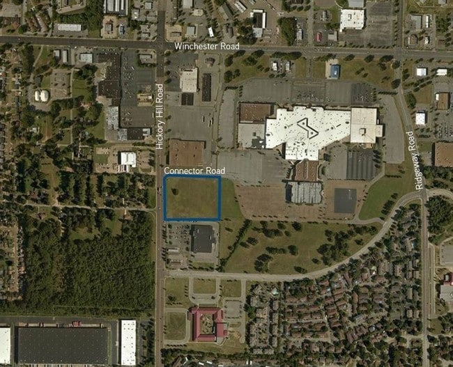
Property Record
Hickory Hill Rd, Memphis, TN 38115

NEARBY LISTINGS FOR SALE OR LEASE
-
-
-
-
No Photo
-
-
-
-
View all Memphis listings for sale on LoopNet.com
Property Detail
Hickory Hill Rd
09-3400-0-0569
ES HICKORY HILL RD
Vacantlandnec
Shelby
X
Tennessee
47157C0465F
6.42 AC
0
385 Corridor
2025
Memphis
021721
Memphis, TN-MS-AR
DEMOGRAPHICS near Hickory Hill Rd
1 Mile
3 Mile
5 Mile
2024 Total Population
14,461
89,551
192,713
2029 Population
14,156
87,803
190,106
Pop Growth 2024-2029
(2.11%)
(1.95%)
(1.35%)
Average Age
32
35
37
2024 Total Households
5,553
33,634
74,774
HH Growth 2024-2029
(2.20%)
(1.92%)
(1.42%)
Median Household Inc
$39,465
$47,339
$57,634
Avg Household Size
2.60
2.60
2.50
2024 Avg HH Vehicles
1.00
2.00
2.00
Median Home Value
$104,184
$149,261
$195,692
Median Year Built
1978
1978
1979
Nearby Places
Map Layers
Map Styles
 Street
 Aerial
- Restaurants
- Banks
- Shops
- Fitness
- Groceries
PUBLIC TRANSPORTATION
AIRPORT
Memphis International
DRIVE
WALK
Distance
Memphis International
13 min
7.8 mi
Freight Ports
Port of Shreveport
DRIVE
WALK
Distance
Port of Shreveport
418 min
381.6 mi
SALE & LEASE HISTORY
LISTING DATE
SALE/LEASE

Sep 24, 2016
For Sale
Nov 04, 2019
For Sale
Jul 16, 2018
For Sale
Nearby Properties
Address
Land Use
TOTAL SIZE
Lot Size
Zoning
Address
Land Use
TOTAL SIZE
Lot Size
Zoning
863,591 SF
35.66 AC
EMP
Address
Land Use
TOTAL SIZE
Lot Size
Zoning
834,463 SF
37.46 AC
EMP
Address
Land Use
TOTAL SIZE
Lot Size
Zoning
794,452 SF
39.72 AC
EMP
Address
Land Use
TOTAL SIZE
Lot Size
Zoning
451,249 SF
24.28 AC
RU-2
Address
Land Use
TOTAL SIZE
Lot Size
Zoning
704,564 SF
28.30 AC
EMP
Address
Land Use
TOTAL SIZE
Lot Size
Zoning
1,403,383 SF
93.69 AC
IH
Address
Land Use
TOTAL SIZE
Lot Size
Zoning
237,911 SF
21.38 AC
EMP
Address
Land Use
TOTAL SIZE
Lot Size
Zoning
498,764 SF
22.57 AC
CA
Address
Land Use
TOTAL SIZE
Lot Size
Zoning
1,292,907 SF
83.13 AC
IH
Address
Land Use
TOTAL SIZE
Lot Size
Zoning
419,065 SF
19.92 AC
EMP
Address
Land Use
TOTAL SIZE
Lot Size
Zoning
1,155,303 SF
61.73 AC
IH
Address
Land Use
TOTAL SIZE
Lot Size
Zoning
16,432 SF
445 AC
EMP
Address
Land Use
TOTAL SIZE
Lot Size
Zoning
262,984 SF
8.09 AC
R-TH
Address
Land Use
TOTAL SIZE
Lot Size
Zoning
903,083 SF
45.12 AC
EMP
Address
Land Use
TOTAL SIZE
Lot Size
Zoning
350,298 SF
12.68 AC
EMP
Address
Land Use
TOTAL SIZE
Lot Size
Zoning
330,758 SF
12.09 AC
EMP
Address
Land Use
TOTAL SIZE
Lot Size
Zoning
715,375 SF
37.51 AC
EMP
Address
Land Use
TOTAL SIZE
Lot Size
Zoning
523,811 SF
19.83 AC
EMP
Address
Land Use
TOTAL SIZE
Lot Size
Zoning
667,793 SF
35.26 AC
IH
Address
Land Use
TOTAL SIZE
Lot Size
Zoning
239,276 SF
17.72 AC
EMP
Address
Land Use
TOTAL SIZE
Lot Size
Zoning
38,488 SF
5.68 AC
CMU-1
Address
Land Use
TOTAL SIZE
Lot Size
Zoning
269,022 SF
23.76 AC
RU-3
Address
Land Use
TOTAL SIZE
Lot Size
Zoning
554,282 SF
67.63 AC
IH
Address
Land Use
TOTAL SIZE
Lot Size
Zoning
51,600 SF
24.06 AC
RU-3
Address
Land Use
TOTAL SIZE
Lot Size
Zoning
689,307 SF
22.68 AC
EMP
Address
Land Use
TOTAL SIZE
Lot Size
Zoning
642,900 SF
29.71 AC
EMP
Address
Land Use
TOTAL SIZE
Lot Size
Zoning
48,768 SF
7.51 AC
R-8
Address
Land Use
TOTAL SIZE
Lot Size
Zoning
618,133 SF
37.58 AC
EMP
Address
Land Use
TOTAL SIZE
Lot Size
Zoning
573,825 SF
32.39 AC
EMP
Address
Land Use
TOTAL SIZE
Lot Size
Zoning
176,176 SF
26.62 AC
R-8
The World's #1 Commercial Real Estate Marketplace
Connect with us
© 2025 CoStar Group
The information above has been obtained from sources believed reliable. While we do not doubt its accuracy we have not verified it and make no guarantee, warranty or representation about it. It is your responsibility to independently confirm its accuracy and completeness. Any projections, opinions, assumptions, or estimates used are for example only and do not represent the current or future performance of the property. The value of this transaction to you depends on tax and other factors which should be evaluated by your tax, financial, and legal advisors. You and your advisors should conduct a careful, independent investigation of the property to determine to your satisfaction the suitability of the property for your needs.