Property Record
Hickory Tree Rd, Saint Cloud, FL 34772

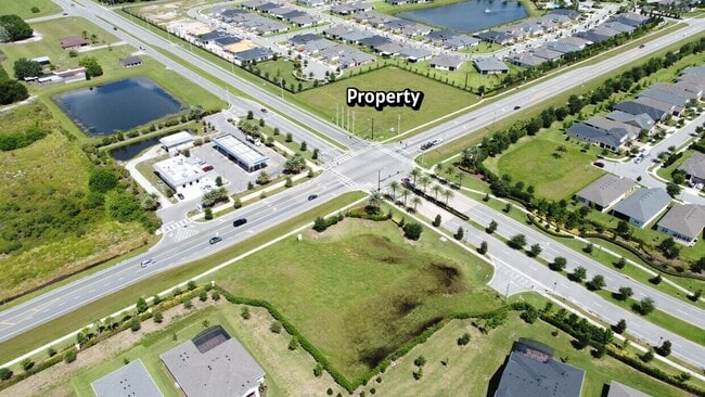
This Property Is For Sale
Property Detail
Hickory Tree Rd
Orlando-Kissimmee-Sanford, FL
S L & I C PB B PG 24 LOTS 49 & 64 LESS COM AT SE COR OF NE 1/4 OF 18-26-31, W 20, N 111.03 FT TO INTER OF N R/W LINE OF NEW NOLTE RD & W R/W LINE OF HICKORY TREE RD, S 57 DEG W 66.28 FT, W 217.77 FT TO POB; CONT W 982.17 FT, N 32 DEG W 49.61 FT, N 25
18-26-31-4950-0001-0640
OSCEOLA
Commercialacreage
Florida
B and X Area of moderate flood hazard, usually the area between the limits of the 100-year and 500-year floods.
49,64
2024
1.73 AC
2025
Osceola Outlying
043304
Orlando
NEARBY LISTINGS FOR SALE OR LEASE
DEMOGRAPHICS near Hickory Tree Rd
1 mile
3 mile
5 mile
2025 Total Population
3,231
32,584
87,685
2030 Population
3,913
38,440
103,005
Pop Growth 2025-2030
+ 21.11%
+ 17.97%
+ 17.47%
Average Age
43
40
39
2025 Total Households
1,220
11,550
30,378
HH Growth 2025-2030
+ 21.97%
+ 18.65%
+ 18.14%
Median Household Inc
$91,585
$91,886
$89,033
Avg Household Size
2.60
2.80
2.90
2025 Avg HH Vehicles
2.00
2.00
2.00
Median Home Value
$410,822
$392,868
$404,899
Median Year Built
2010
2004
2005
Nearby Places
Map Layers
Map Styles
 Street
 Aerial
Transit
 Traffic
 Biking
Places
Listings with unknown addresses are not visible on the map
- Restaurants
- Banks
- Shops
- Fitness
- Groceries
PUBLIC TRANSPORTATION
AIRPORT
Orlando International
Drive
Walk
Distance
Orlando International
38 min
22.3 mi
Nearby Properties
Address
Land Use
TOTAL SIZE
Lot Size
Zoning
Address
Land Use
TOTAL SIZE
Lot Size
Zoning
313,120 SF
54.86 AC
SP
Address
Land Use
TOTAL SIZE
Lot Size
Zoning
185,953 SF
63.41 AC
SP
Address
Land Use
TOTAL SIZE
Lot Size
Zoning
77,928 SF
24.79 AC
SHB
Address
Land Use
TOTAL SIZE
Lot Size
Zoning
127,960 SF
14.40 AC
SPUD
Address
Land Use
TOTAL SIZE
Lot Size
Zoning
55,521 SF
10.75 AC
SHB
Address
Land Use
TOTAL SIZE
Lot Size
Zoning
89,482 SF
4.82 AC
SPUD
Address
Land Use
TOTAL SIZE
Lot Size
Zoning
13.38 AC
Address
Land Use
TOTAL SIZE
Lot Size
Zoning
60,211 SF
6.46 AC
SPUD
Address
Land Use
TOTAL SIZE
Lot Size
Zoning
44,380 SF
7.84 AC
SHB
Address
Land Use
TOTAL SIZE
Lot Size
Zoning
57,600 SF
4.83 AC
SHB
Address
Land Use
TOTAL SIZE
Lot Size
Zoning
13,900 SF
3.90 AC
SI3
Address
Land Use
TOTAL SIZE
Lot Size
Zoning
50,570 SF
4.98 AC
SPUD
Address
Land Use
TOTAL SIZE
Lot Size
Zoning
14,234 SF
1.79 AC
SHB
Address
Land Use
TOTAL SIZE
Lot Size
Zoning
68,472 SF
0.80 AC
SCB1
Address
Land Use
TOTAL SIZE
Lot Size
Zoning
23,000 SF
3.09 AC
SI3
Address
Land Use
TOTAL SIZE
Lot Size
Zoning
48,306 SF
3.13 AC
SHB
Address
Land Use
TOTAL SIZE
Lot Size
Zoning
4,308 SF
1.84 AC
RM-2
Address
Land Use
TOTAL SIZE
Lot Size
Zoning
46,404 SF
29.13 AC
SP
Address
Land Use
TOTAL SIZE
Lot Size
Zoning
50,442 SF
13.86 AC
E-1
Address
Land Use
TOTAL SIZE
Lot Size
Zoning
35,838 SF
20.56 AC
SA
Address
Land Use
TOTAL SIZE
Lot Size
Zoning
44,565 SF
7 AC
AC
Address
Land Use
TOTAL SIZE
Lot Size
Zoning
5,755 SF
1.76 AC
SHB
Address
Land Use
TOTAL SIZE
Lot Size
Zoning
31,640 SF
2.04 AC
SI3
Address
Land Use
TOTAL SIZE
Lot Size
Zoning
31,430 SF
2.07 AC
SI3
Address
Land Use
TOTAL SIZE
Lot Size
Zoning
1,104 SF
11.77 AC
OCG
Address
Land Use
TOTAL SIZE
Lot Size
Zoning
25,232 SF
254.03 AC
SAC
Address
Land Use
TOTAL SIZE
Lot Size
Zoning
17,136 SF
1.98 AC
SPUD
Address
Land Use
TOTAL SIZE
Lot Size
Zoning
30,200 SF
2.62 AC
OCR
Address
Land Use
TOTAL SIZE
Lot Size
Zoning
58,272 SF
4.58 AC
ORM2
Address
Land Use
TOTAL SIZE
Lot Size
Zoning
16,830 SF
3.15 AC
SI3
The World's #1 Commercial Real Estate Marketplace
Connect with us
© 2026 CoStar Group
The information above has been obtained from sources believed reliable. While we do not doubt its accuracy we have not verified it and make no guarantee, warranty or representation about it. It is your responsibility to independently confirm its accuracy and completeness. Any projections, opinions, assumptions, or estimates used are for example only and do not represent the current or future performance of the property. The value of this transaction to you depends on tax and other factors which should be evaluated by your tax, financial, and legal advisors. You and your advisors should conduct a careful, independent investigation of the property to determine to your satisfaction the suitability of the property for your needs.