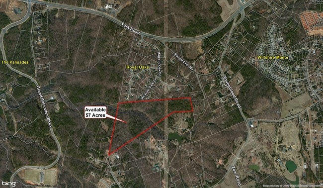
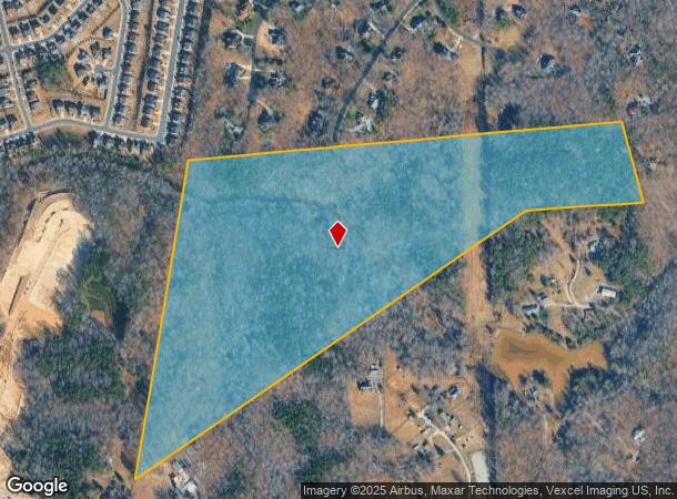
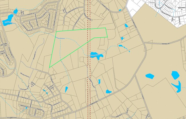
Property Record
Capps Rd, Charlotte, NC 28278
NEARBY LISTINGS FOR SALE OR LEASE
Property Detail
Capps Rd
217-241-20
Mecklenburg
Sfr
North Carolina
X
20
3710349900J
57 AC
2022
Airport
2025
Charlotte
005910
Charlotte-Concord-Gastonia, NC-SC
DEMOGRAPHICS near Capps Rd
1 mile
3 mile
5 mile
2024 Total Population
3,788
52,352
114,210
2029 Population
4,228
57,365
126,263
Pop Growth 2024-2029
+ 11.62%
+ 9.58%
+ 10.55%
Average Age
44
38
39
2024 Total Households
1,523
19,825
43,440
HH Growth 2024-2029
+ 11.82%
+ 9.74%
+ 10.74%
Median Household Inc
$139,305
$111,195
$105,489
Avg Household Size
2.50
2.60
2.60
2024 Avg HH Vehicles
2.00
2.00
2.00
Median Home Value
$451,446
$380,369
$380,469
Median Year Built
2011
2007
2006
Nearby Places
Map Layers
Map Styles
 Street
 Aerial
Transit
 Traffic
 Biking
Places
Listings with unknown addresses are not visible on the map
- Restaurants
- Banks
- Shops
- Fitness
- Groceries
PUBLIC TRANSPORTATION
AIRPORT
Charlotte/Douglas International
Drive
Walk
Distance
Charlotte/Douglas International
24 min
11.9 mi
Concord-Padgett Regional
Drive
Walk
Distance
Concord-Padgett Regional
45 min
33.5 mi
Freight Ports
North Charleston Terminal
Drive
Walk
Distance
North Charleston Terminal
218 min
190.3 mi
SALE & LEASE HISTORY
LISTING DATE
SALE/LEASE

Sep 24, 2016
For Sale
Nearby Properties
Address
Land Use
TOTAL SIZE
Lot Size
Zoning
Address
Land Use
TOTAL SIZE
Lot Size
Zoning
432,123 SF
36.75 AC
R17MFCD
Address
Land Use
TOTAL SIZE
Lot Size
Zoning
415,150 SF
18.68 AC
MX-3
Address
Land Use
TOTAL SIZE
Lot Size
Zoning
298,790 SF
18.23 AC
MX3
Address
Land Use
TOTAL SIZE
Lot Size
Zoning
283,424 SF
24.95 AC
R17MFCD
Address
Land Use
TOTAL SIZE
Lot Size
Zoning
369,622 SF
26.29 AC
R17MFCD
Address
Land Use
TOTAL SIZE
Lot Size
Zoning
252,275 SF
20.23 AC
Address
Land Use
TOTAL SIZE
Lot Size
Zoning
250,307 SF
15.53 AC
R17MFCD
Address
Land Use
TOTAL SIZE
Lot Size
Zoning
218,322 SF
15.93 AC
R17MFCD
Address
Land Use
TOTAL SIZE
Lot Size
Zoning
269,639 SF
15.32 AC
R17MFCD
Address
Land Use
TOTAL SIZE
Lot Size
Zoning
275,215 SF
12.35 AC
R17MFCD
Address
Land Use
TOTAL SIZE
Lot Size
Zoning
124,458 SF
17.15 AC
CC
Address
Land Use
TOTAL SIZE
Lot Size
Zoning
145,486 SF
16.78 AC
R17MFCD
Address
Land Use
TOTAL SIZE
Lot Size
Zoning
113,825 SF
10.54 AC
CC
Address
Land Use
TOTAL SIZE
Lot Size
Zoning
148,605 SF
13.11 AC
Address
Land Use
TOTAL SIZE
Lot Size
Zoning
113,925 SF
5.46 AC
Address
Land Use
TOTAL SIZE
Lot Size
Zoning
91,440 SF
8.52 AC
Address
Land Use
TOTAL SIZE
Lot Size
Zoning
238.36 AC
R-3
Address
Land Use
TOTAL SIZE
Lot Size
Zoning
147,294 SF
40.21 AC
UR-2(CD)
Address
Land Use
TOTAL SIZE
Lot Size
Zoning
175,119 SF
12.76 AC
CC
Address
Land Use
TOTAL SIZE
Lot Size
Zoning
972 SF
6.91 AC
B-2
Address
Land Use
TOTAL SIZE
Lot Size
Zoning
35,824 SF
1.90 AC
CC
Address
Land Use
TOTAL SIZE
Lot Size
Zoning
88,944 SF
13.06 AC
R-4(CD)
Address
Land Use
TOTAL SIZE
Lot Size
Zoning
89,902 SF
28.37 AC
R-3
Address
Land Use
TOTAL SIZE
Lot Size
Zoning
142.43 AC
R-3
Address
Land Use
TOTAL SIZE
Lot Size
Zoning
66,569 SF
9.37 AC
CC
Address
Land Use
TOTAL SIZE
Lot Size
Zoning
45,720 SF
2.93 AC
Address
Land Use
TOTAL SIZE
Lot Size
Zoning
75,288 SF
18.08 AC
R-3
Address
Land Use
TOTAL SIZE
Lot Size
Zoning
29,822 SF
15.81 AC
R3
Address
Land Use
TOTAL SIZE
Lot Size
Zoning
104,382 SF
9.73 AC
CC
Address
Land Use
TOTAL SIZE
Lot Size
Zoning
84,134 SF
7.13 AC
The World's #1 Commercial Real Estate Marketplace
Connect with us
© 2026 CoStar Group
The information above has been obtained from sources believed reliable. While we do not doubt its accuracy we have not verified it and make no guarantee, warranty or representation about it. It is your responsibility to independently confirm its accuracy and completeness. Any projections, opinions, assumptions, or estimates used are for example only and do not represent the current or future performance of the property. The value of this transaction to you depends on tax and other factors which should be evaluated by your tax, financial, and legal advisors. You and your advisors should conduct a careful, independent investigation of the property to determine to your satisfaction the suitability of the property for your needs.