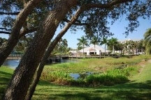
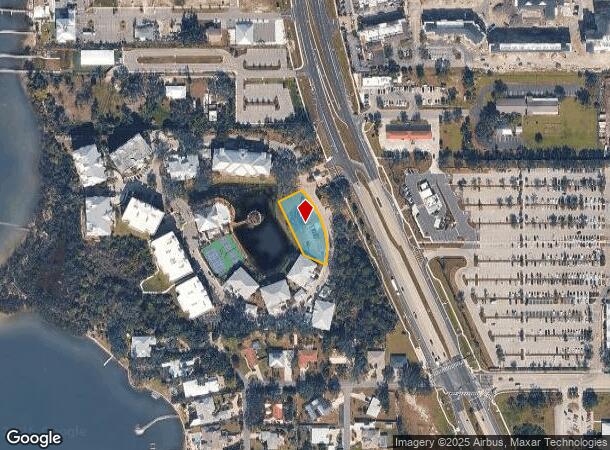
Property Record
Hidden Bay Dr, Osprey, FL 34229
NEARBY LISTINGS FOR SALE OR LEASE
Property Detail
Hidden Bay Dr
North Port-Sarasota-Bradenton, FL
Sarabay Acres
0147-06-0008
DEVELOPMENT PARCEL 2 AS DESC IN ORI 2006205427, SARABAY ACRES
Vacantlandnec
Sarasota
X
Florida
12115C0228G
0.55 AC
2024
Sarasota
2025
Tampa/St Petersburg
002102
DEMOGRAPHICS near Hidden Bay Dr
1 Mile
3 Mile
5 Mile
2024 Total Population
2,727
25,410
58,089
2029 Population
3,115
29,570
67,646
Pop Growth 2024-2029
+ 14.23%
+ 16.37%
+ 16.45%
Average Age
58
57
56
2024 Total Households
1,440
12,959
29,281
HH Growth 2024-2029
+ 14.17%
+ 16.48%
+ 16.54%
Median Household Inc
$72,211
$87,718
$84,885
Avg Household Size
1.90
1.90
1.90
2024 Avg HH Vehicles
2.00
2.00
2.00
Median Home Value
$521,716
$475,166
$421,266
Median Year Built
2002
1994
1990
Nearby Places
Map Layers
Map Styles
 Street
 Aerial
- Restaurants
- Banks
- Shops
- Fitness
- Groceries
PUBLIC TRANSPORTATION
AIRPORT
Sarasota/Bradenton International
DRIVE
WALK
Distance
Sarasota/Bradenton International
30 min
16.5 mi
Freight Ports
Port Manatee
DRIVE
WALK
Distance
Port Manatee
52 min
41.5 mi
SALE & LEASE HISTORY
LISTING DATE
SALE/LEASE

Feb 20, 2024
For Sale
Nearby Properties
Address
Land Use
TOTAL SIZE
Lot Size
Zoning
Address
Land Use
TOTAL SIZE
Lot Size
Zoning
530,029 SF
14.92 AC
RMF4
Address
Land Use
TOTAL SIZE
Lot Size
Zoning
289,996 SF
20.95 AC
RMF3
Address
Land Use
TOTAL SIZE
Lot Size
Zoning
318,414 SF
22.35 AC
RMF1
Address
Land Use
TOTAL SIZE
Lot Size
Zoning
242,685 SF
26.67 AC
RMF1
Address
Land Use
TOTAL SIZE
Lot Size
Zoning
244,492 SF
73.19 AC
GU
Address
Land Use
TOTAL SIZE
Lot Size
Zoning
175,813 SF
10.09 AC
CG
Address
Land Use
TOTAL SIZE
Lot Size
Zoning
17,785 SF
56.32 AC
RMF2
Address
Land Use
TOTAL SIZE
Lot Size
Zoning
148,339 SF
12.86 AC
CG
Address
Land Use
TOTAL SIZE
Lot Size
Zoning
124,423 SF
76 AC
GU
Address
Land Use
TOTAL SIZE
Lot Size
Zoning
145,945 SF
13.93 AC
CG
Address
Land Use
TOTAL SIZE
Lot Size
Zoning
73,121 SF
426.09 AC
OUE2
Address
Land Use
TOTAL SIZE
Lot Size
Zoning
209,566 SF
18.63 AC
CG
Address
Land Use
TOTAL SIZE
Lot Size
Zoning
12,552 SF
6.73 AC
RE2
Address
Land Use
TOTAL SIZE
Lot Size
Zoning
46,727 SF
38.73 AC
CG
Address
Land Use
TOTAL SIZE
Lot Size
Zoning
17,028 SF
3.57 AC
RE2
Address
Land Use
TOTAL SIZE
Lot Size
Zoning
64,581 SF
11.85 AC
CG
Address
Land Use
TOTAL SIZE
Lot Size
Zoning
150,217 SF
14.83 AC
CG
Address
Land Use
TOTAL SIZE
Lot Size
Zoning
88,509 SF
12.03 AC
CG
Address
Land Use
TOTAL SIZE
Lot Size
Zoning
111,041 SF
20 AC
CG
Address
Land Use
TOTAL SIZE
Lot Size
Zoning
8,407 SF
30.21 AC
RSF1
Address
Land Use
TOTAL SIZE
Lot Size
Zoning
7,969 SF
38.20 AC
RMH
Address
Land Use
TOTAL SIZE
Lot Size
Zoning
15,095 SF
2.78 AC
RE2
Address
Land Use
TOTAL SIZE
Lot Size
Zoning
704 SF
1.80 AC
RSF1
Address
Land Use
TOTAL SIZE
Lot Size
Zoning
16,879 SF
8.60 AC
RE2
Address
Land Use
TOTAL SIZE
Lot Size
Zoning
89,684 SF
2.42 AC
CG
Address
Land Use
TOTAL SIZE
Lot Size
Zoning
68,641 SF
6.40 AC
RTR
Address
Land Use
TOTAL SIZE
Lot Size
Zoning
119,994 SF
17.06 AC
CG
Address
Land Use
TOTAL SIZE
Lot Size
Zoning
112,188 SF
10.75 AC
CG
Address
Land Use
TOTAL SIZE
Lot Size
Zoning
314,254 SF
8.15 AC
RMF3
Address
Land Use
TOTAL SIZE
Lot Size
Zoning
16,033 SF
1.93 AC
RE1
The World's #1 Commercial Real Estate Marketplace
Connect with us
© 2025 CoStar Group
The information above has been obtained from sources believed reliable. While we do not doubt its accuracy we have not verified it and make no guarantee, warranty or representation about it. It is your responsibility to independently confirm its accuracy and completeness. Any projections, opinions, assumptions, or estimates used are for example only and do not represent the current or future performance of the property. The value of this transaction to you depends on tax and other factors which should be evaluated by your tax, financial, and legal advisors. You and your advisors should conduct a careful, independent investigation of the property to determine to your satisfaction the suitability of the property for your needs.