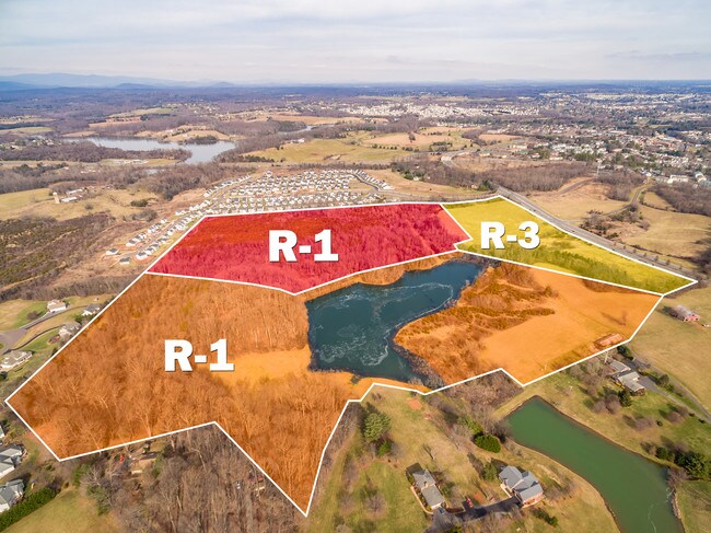
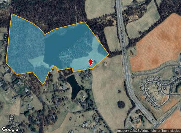
Property Record
Hidden Lks, Culpeper, VA 22701
NEARBY LISTINGS FOR SALE OR LEASE
Property Detail
Hidden Lks
50-7
MADISON ROAD PLAT CAB 6/146
Agriculturalland
Culpeper
X
Virginia
51047C0209D
43.02 AC
2024
Suburban Virginia Area
2025
Other Market Areas
930204
Washington-Arlington-Alexandria, DC-VA-MD-WV
DEMOGRAPHICS near Hidden Lks
1 Mile
3 Mile
5 Mile
2024 Total Population
3,598
21,328
33,414
2029 Population
3,947
23,396
36,557
Pop Growth 2024-2029
+ 9.70%
+ 9.70%
+ 9.41%
Average Age
40
38
39
2024 Total Households
1,333
7,282
11,444
HH Growth 2024-2029
+ 9.83%
+ 9.91%
+ 9.59%
Median Household Inc
$79,579
$86,661
$86,204
Avg Household Size
2.60
2.80
2.80
2024 Avg HH Vehicles
2.00
2.00
2.00
Median Home Value
$321,389
$337,370
$333,807
Median Year Built
1993
1994
1993
Nearby Places
Map Layers
Map Styles
 Street
 Aerial
- Restaurants
- Banks
- Shops
- Fitness
- Groceries
PUBLIC TRANSPORTATION
COMMUTER RAIL
Culpeper Amtrak Station (Cardinal - Amtrak, Crescent - Amtrak, Northeast Regional - Amtrak)
DRIVE
WALK
Distance
Culpeper Amtrak Station (Cardinal - Amtrak, Crescent - Amtrak, Northeast Regional - Amtrak)
8 min
3.6 mi
Freight Ports
Virginia Port Authority - Richmond
DRIVE
WALK
Distance
Virginia Port Authority - Richmond
124 min
95.2 mi
SALE & LEASE HISTORY
LISTING DATE
SALE/LEASE

Sep 24, 2016
For Sale
Nearby Properties
Address
Land Use
TOTAL SIZE
Lot Size
Zoning
Address
Land Use
TOTAL SIZE
Lot Size
Zoning
377,903 SF
30.12 AC
LI
Address
Land Use
TOTAL SIZE
Lot Size
Zoning
386,833 SF
15.80 AC
R1
Address
Land Use
TOTAL SIZE
Lot Size
Zoning
147,265 SF
29.61 AC
M1
Address
Land Use
TOTAL SIZE
Lot Size
Zoning
166,825 SF
11.09 AC
R2
Address
Land Use
TOTAL SIZE
Lot Size
Zoning
135,497 SF
108.90 AC
R2
Address
Land Use
TOTAL SIZE
Lot Size
Zoning
58.15 AC
M2
Address
Land Use
TOTAL SIZE
Lot Size
Zoning
58.15 AC
M2
Address
Land Use
TOTAL SIZE
Lot Size
Zoning
54.85 AC
LI
Address
Land Use
TOTAL SIZE
Lot Size
Zoning
41.97 AC
LI
Address
Land Use
TOTAL SIZE
Lot Size
Zoning
19,602 SF
10.32 AC
M1
Address
Land Use
TOTAL SIZE
Lot Size
Zoning
35.27 AC
M2
Address
Land Use
TOTAL SIZE
Lot Size
Zoning
34.64 AC
M2
Address
Land Use
TOTAL SIZE
Lot Size
Zoning
66,558 SF
29.23 AC
R2
Address
Land Use
TOTAL SIZE
Lot Size
Zoning
6,294 SF
33.37 AC
M2
Address
Land Use
TOTAL SIZE
Lot Size
Zoning
38,890 SF
32.91 AC
LIRA
Address
Land Use
TOTAL SIZE
Lot Size
Zoning
230,016 SF
89.13 AC
LI
Address
Land Use
TOTAL SIZE
Lot Size
Zoning
28.26 AC
LI
Address
Land Use
TOTAL SIZE
Lot Size
Zoning
82,000 SF
13.24 AC
R1
Address
Land Use
TOTAL SIZE
Lot Size
Zoning
55,920 SF
3.68 AC
C3
Address
Land Use
TOTAL SIZE
Lot Size
Zoning
1,080 SF
6.92 AC
R3
Address
Land Use
TOTAL SIZE
Lot Size
Zoning
20.48 AC
LI
Address
Land Use
TOTAL SIZE
Lot Size
Zoning
35,061 SF
3.51 AC
C1
Address
Land Use
TOTAL SIZE
Lot Size
Zoning
13,536 SF
9.84 AC
R4
Address
Land Use
TOTAL SIZE
Lot Size
Zoning
59,210 SF
4.40 AC
R1R3
Address
Land Use
TOTAL SIZE
Lot Size
Zoning
17.39 AC
LI
Address
Land Use
TOTAL SIZE
Lot Size
Zoning
282,110 SF
30.44 AC
M2
Address
Land Use
TOTAL SIZE
Lot Size
Zoning
53,978 SF
10 AC
R2
Address
Land Use
TOTAL SIZE
Lot Size
Zoning
15.70 AC
LI
Address
Land Use
TOTAL SIZE
Lot Size
Zoning
126,869 SF
25.68 AC
M2
Address
Land Use
TOTAL SIZE
Lot Size
Zoning
27,661 SF
1.21 AC
C2
The World's #1 Commercial Real Estate Marketplace
Connect with us
© 2025 CoStar Group
The information above has been obtained from sources believed reliable. While we do not doubt its accuracy we have not verified it and make no guarantee, warranty or representation about it. It is your responsibility to independently confirm its accuracy and completeness. Any projections, opinions, assumptions, or estimates used are for example only and do not represent the current or future performance of the property. The value of this transaction to you depends on tax and other factors which should be evaluated by your tax, financial, and legal advisors. You and your advisors should conduct a careful, independent investigation of the property to determine to your satisfaction the suitability of the property for your needs.