Property Record
High, Girard, OH 44420
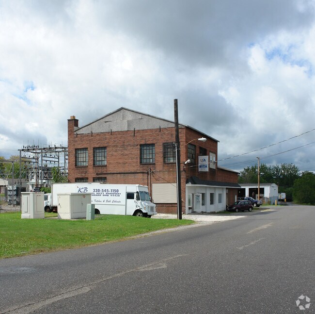


Property Detail
High
Youngstown-Warren, OH
7-8-9 .40A GIRARD SUBSTATION BLOCK 11 GIRARD CITY
14-607132
TRUMBULL
Storebuilding
Ohio
B and X Area of moderate flood hazard, usually the area between the limits of the 100-year and 500-year floods.
7
2025
0.40 AC
2025
Trumbull County
932300
Youngstown/Warren/Boardman
6,750 SF
NEARBY LISTINGS FOR SALE OR LEASE
DEMOGRAPHICS near High
1 mile
3 mile
5 mile
2025 Total Population
6,820
32,147
90,583
2030 Population
6,754
31,826
89,989
Pop Growth 2025-2030
(0.97%)
(1.00%)
(0.66%)
Average Age
41
43
42
2025 Total Households
2,998
14,258
39,007
HH Growth 2025-2030
(1.07%)
(1.03%)
(0.74%)
Median Household Inc
$40,108
$47,439
$44,287
Avg Household Size
2.20
2.20
2.20
2025 Avg HH Vehicles
2.00
2.00
2.00
Median Home Value
$108,623
$129,240
$118,423
Median Year Built
1952
1959
1959
Nearby Places
Map Layers
Map Styles
 Street
 Aerial
Layers
 Traffic
 Biking
Places
Listings with unknown addresses are not visible on the map
- Restaurants
- Banks
- Shops
- Fitness
- Groceries
Nearby Properties
Address
Land Use
TOTAL SIZE
Lot Size
Zoning
Address
Land Use
TOTAL SIZE
Lot Size
Zoning
981,460 SF
74.87 AC
Address
Land Use
TOTAL SIZE
Lot Size
Zoning
10.30 AC
Address
Land Use
TOTAL SIZE
Lot Size
Zoning
67,680 SF
22.66 AC
Address
Land Use
TOTAL SIZE
Lot Size
Zoning
33,819 SF
25 AC
Address
Land Use
TOTAL SIZE
Lot Size
Zoning
6.58 AC
Address
Land Use
TOTAL SIZE
Lot Size
Zoning
55,398 SF
36.73 AC
Address
Land Use
TOTAL SIZE
Lot Size
Zoning
6,207 SF
0.88 AC
Address
Land Use
TOTAL SIZE
Lot Size
Zoning
446,250 SF
43.88 AC
Address
Land Use
TOTAL SIZE
Lot Size
Zoning
89,325 SF
28.74 AC
Address
Land Use
TOTAL SIZE
Lot Size
Zoning
116,176 SF
5.04 AC
Address
Land Use
TOTAL SIZE
Lot Size
Zoning
166,146 SF
22.30 AC
Address
Land Use
TOTAL SIZE
Lot Size
Zoning
9,999 SF
19.67 AC
Address
Land Use
TOTAL SIZE
Lot Size
Zoning
5,616 SF
23.43 AC
Address
Land Use
TOTAL SIZE
Lot Size
Zoning
200,160 SF
19.03 AC
Address
Land Use
TOTAL SIZE
Lot Size
Zoning
54,969 SF
6.17 AC
Address
Land Use
TOTAL SIZE
Lot Size
Zoning
Address
Land Use
TOTAL SIZE
Lot Size
Zoning
68,888 SF
3 AC
Address
Land Use
TOTAL SIZE
Lot Size
Zoning
57,266 SF
5.84 AC
Address
Land Use
TOTAL SIZE
Lot Size
Zoning
23,760 SF
7.40 AC
Address
Land Use
TOTAL SIZE
Lot Size
Zoning
11,316 SF
8.86 AC
Address
Land Use
TOTAL SIZE
Lot Size
Zoning
53,934 SF
2.59 AC
Address
Land Use
TOTAL SIZE
Lot Size
Zoning
69,267 SF
12.72 AC
Address
Land Use
TOTAL SIZE
Lot Size
Zoning
36,921 SF
3.47 AC
Address
Land Use
TOTAL SIZE
Lot Size
Zoning
66,738 SF
9.35 AC
Address
Land Use
TOTAL SIZE
Lot Size
Zoning
143,789 SF
20.18 AC
Address
Land Use
TOTAL SIZE
Lot Size
Zoning
76,220 SF
12.16 AC
Address
Land Use
TOTAL SIZE
Lot Size
Zoning
72,771 SF
2.63 AC
Address
Land Use
TOTAL SIZE
Lot Size
Zoning
122,156 SF
10.77 AC
Address
Land Use
TOTAL SIZE
Lot Size
Zoning
20,431 SF
29.41 AC
Address
Land Use
TOTAL SIZE
Lot Size
Zoning
98,943 SF
1.48 AC
The World's #1 Commercial Real Estate Marketplace
Connect with us
© 2026 CoStar Group
The information above has been obtained from sources believed reliable. While we do not doubt its accuracy we have not verified it and make no guarantee, warranty or representation about it. It is your responsibility to independently confirm its accuracy and completeness. Any projections, opinions, assumptions, or estimates used are for example only and do not represent the current or future performance of the property. The value of this transaction to you depends on tax and other factors which should be evaluated by your tax, financial, and legal advisors. You and your advisors should conduct a careful, independent investigation of the property to determine to your satisfaction the suitability of the property for your needs.