Property Record
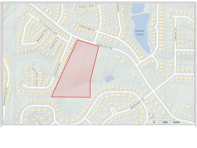
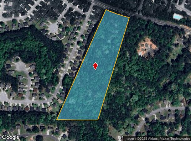
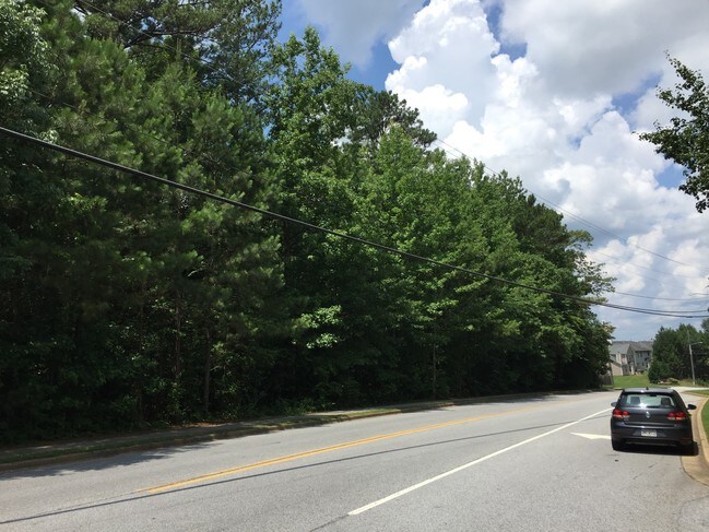
High Point Rd, Union City, GA 30291
NEARBY LISTINGS FOR SALE OR LEASE
Property Detail
High Point Rd
Atlanta-Sandy Springs-Roswell, GA
Mrs Lake Line Prop
09F-2102-0098-012-6
AN RAZ
Residentialacreage
Fulton
X
Georgia
13121C0452F
9
2024
8.78 AC
2025
North Clayton/Airport
010524
Atlanta
DEMOGRAPHICS near High Point Rd
1 Mile
3 Mile
5 Mile
2024 Total Population
6,811
39,707
110,598
2029 Population
7,008
41,049
114,255
Pop Growth 2024-2029
+ 2.89%
+ 3.38%
+ 3.31%
Average Age
35
36
37
2024 Total Households
2,283
14,380
40,771
HH Growth 2024-2029
+ 2.98%
+ 3.46%
+ 3.36%
Median Household Inc
$58,838
$60,974
$70,432
Avg Household Size
2.80
2.70
2.70
2024 Avg HH Vehicles
2.00
2.00
2.00
Median Home Value
$200,742
$213,190
$218,150
Median Year Built
2002
2001
2002
Nearby Places
Map Layers
Map Styles
 Street
 Aerial
- Restaurants
- Banks
- Shops
- Fitness
- Groceries
PUBLIC TRANSPORTATION
AIRPORT
Hartsfield - Jackson Atlanta International
DRIVE
WALK
Distance
Hartsfield - Jackson Atlanta International
21 min
12.4 mi
Freight Ports
Georgia Ports - Savannah
DRIVE
WALK
Distance
Georgia Ports - Savannah
283 min
249.6 mi
SALE & LEASE HISTORY
LISTING DATE
SALE/LEASE

Aug 22, 2017
For Sale
Nearby Properties
Address
Land Use
TOTAL SIZE
Lot Size
Zoning
Address
Land Use
TOTAL SIZE
Lot Size
Zoning
929,571 SF
65.66 AC
M1
Address
Land Use
TOTAL SIZE
Lot Size
Zoning
14.13 AC
TCMU
Address
Land Use
TOTAL SIZE
Lot Size
Zoning
11.10 AC
SUBC
Address
Land Use
TOTAL SIZE
Lot Size
Zoning
74.44 AC
Address
Land Use
TOTAL SIZE
Lot Size
Zoning
992,870 SF
59.71 AC
M1
Address
Land Use
TOTAL SIZE
Lot Size
Zoning
595,060 SF
62.71 AC
Address
Land Use
TOTAL SIZE
Lot Size
Zoning
1,020,000 SF
59.94 AC
Address
Land Use
TOTAL SIZE
Lot Size
Zoning
1,325,500 SF
101.81 AC
AG1
Address
Land Use
TOTAL SIZE
Lot Size
Zoning
78.33 AC
Address
Land Use
TOTAL SIZE
Lot Size
Zoning
1,052,500 SF
184.50 AC
AG1
Address
Land Use
TOTAL SIZE
Lot Size
Zoning
744,000 SF
60.69 AC
GC
Address
Land Use
TOTAL SIZE
Lot Size
Zoning
1,873,575 SF
50.47 AC
RM
Address
Land Use
TOTAL SIZE
Lot Size
Zoning
997,011 SF
68.07 AC
M1
Address
Land Use
TOTAL SIZE
Lot Size
Zoning
39.08 AC
SUBC
Address
Land Use
TOTAL SIZE
Lot Size
Zoning
768,288 SF
40.65 AC
M1
Address
Land Use
TOTAL SIZE
Lot Size
Zoning
130,516 SF
6.50 AC
C1
Address
Land Use
TOTAL SIZE
Lot Size
Zoning
606,450 SF
34.63 AC
M1
Address
Land Use
TOTAL SIZE
Lot Size
Zoning
247,088 SF
20.90 AC
Address
Land Use
TOTAL SIZE
Lot Size
Zoning
773,776 SF
61.42 AC
M1
Address
Land Use
TOTAL SIZE
Lot Size
Zoning
669,152 SF
39.13 AC
M1C
Address
Land Use
TOTAL SIZE
Lot Size
Zoning
546,520 SF
31.54 AC
M1C
Address
Land Use
TOTAL SIZE
Lot Size
Zoning
567,000 SF
41.83 AC
AG1
Address
Land Use
TOTAL SIZE
Lot Size
Zoning
628,193 SF
56.10 AC
M1
Address
Land Use
TOTAL SIZE
Lot Size
Zoning
499,950 SF
63.40 AC
AG1
Address
Land Use
TOTAL SIZE
Lot Size
Zoning
234,763 SF
22.43 AC
OI
Address
Land Use
TOTAL SIZE
Lot Size
Zoning
31.58 AC
Address
Land Use
TOTAL SIZE
Lot Size
Zoning
1,320,344 SF
0.35 AC
MIX
Address
Land Use
TOTAL SIZE
Lot Size
Zoning
661,312 SF
11.40 AC
RM
Address
Land Use
TOTAL SIZE
Lot Size
Zoning
1,466,922 SF
21.58 AC
C1
Address
Land Use
TOTAL SIZE
Lot Size
Zoning
2,404,061 SF
20.21 AC
RM
The World's #1 Commercial Real Estate Marketplace
Connect with us
© 2025 CoStar Group
The information above has been obtained from sources believed reliable. While we do not doubt its accuracy we have not verified it and make no guarantee, warranty or representation about it. It is your responsibility to independently confirm its accuracy and completeness. Any projections, opinions, assumptions, or estimates used are for example only and do not represent the current or future performance of the property. The value of this transaction to you depends on tax and other factors which should be evaluated by your tax, financial, and legal advisors. You and your advisors should conduct a careful, independent investigation of the property to determine to your satisfaction the suitability of the property for your needs.