Property Record
Highbridge Rd, Bordentown, NJ 08505
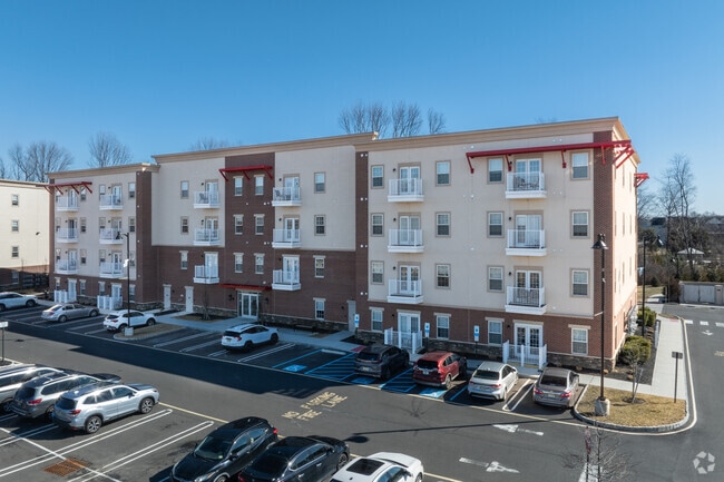

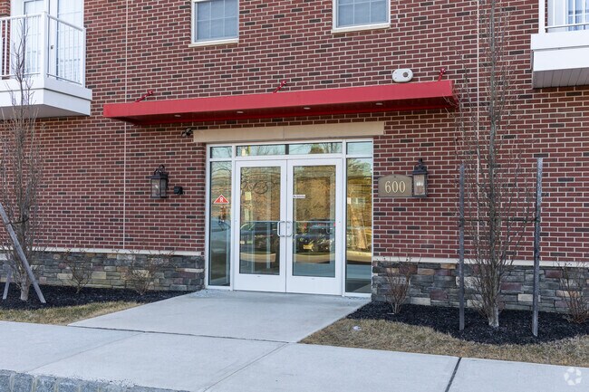
Property Detail
Highbridge Rd
Philadelphia-Camden-Wilmington, PA-NJ-DE-MD
BURLINGTON
04-00058-0000-00037
New Jersey
Apartment
37
B and X Area of moderate flood hazard, usually the area between the limits of the 100-year and 500-year floods.
4.12 AC
2024
Burlington County
2025
Philadelphia
704202
NEARBY LISTINGS FOR SALE OR LEASE
-
-
View all Bordentown listings for sale on LoopNet.com
DEMOGRAPHICS near Highbridge Rd
1 mile
3 mile
5 mile
2025 Total Population
6,404
46,714
140,379
2030 Population
6,604
48,002
143,647
Pop Growth 2025-2030
+ 3.12%
+ 2.76%
+ 2.33%
Average Age
39
42
40
2025 Total Households
1,868
17,333
49,616
HH Growth 2025-2030
+ 4.01%
+ 2.91%
+ 2.57%
Median Household Inc
$105,529
$106,155
$86,308
Avg Household Size
2.50
2.50
2.70
2025 Avg HH Vehicles
2.00
2.00
2.00
Median Home Value
$353,269
$352,803
$333,333
Median Year Built
1963
1961
1958
Nearby Places
Map Layers
Map Styles
 Street
 Aerial
Layers
 Traffic
 Biking
Places
Listings with unknown addresses are not visible on the map
- Restaurants
- Banks
- Shops
- Fitness
- Groceries
PUBLIC TRANSPORTATION
COMMUTER RAIL
Trenton Transit Center (Trenton Line - SEPTA)
Drive
Walk
Distance
Trenton Transit Center (Trenton Line - SEPTA)
13 min
6.4 mi
Trenton Transit Center (Njt) (Northeast Corridor Line - NJ Transit Commuter Rail (NJ Transit), R7 - NJ Transit Commuter Rail (NJ Transit), River LINE - NJ Transit Commuter Rail (NJ Transit))
Drive
Walk
Distance
Trenton Transit Center (Njt) (Northeast Corridor Line - NJ Transit Commuter Rail (NJ Transit), R7 - NJ Transit Commuter Rail (NJ Transit), River LINE - NJ Transit Commuter Rail (NJ Transit))
15 min
7.2 mi
AIRPORT
Trenton Mercer
Drive
Walk
Distance
Trenton Mercer
24 min
13.3 mi
Freight Ports
Port of Philadelphia
Drive
Walk
Distance
Port of Philadelphia
42 min
31.9 mi
Nearby Properties
Address
Land Use
TOTAL SIZE
Lot Size
Zoning
Address
Land Use
TOTAL SIZE
Lot Size
Zoning
561.91 AC
AG
Address
Land Use
TOTAL SIZE
Lot Size
Zoning
30.94 AC
Address
Land Use
TOTAL SIZE
Lot Size
Zoning
51.10 AC
Address
Land Use
TOTAL SIZE
Lot Size
Zoning
60.26 AC
RD
Address
Land Use
TOTAL SIZE
Lot Size
Zoning
392,050 SF
45.57 AC
Address
Land Use
TOTAL SIZE
Lot Size
Zoning
Address
Land Use
TOTAL SIZE
Lot Size
Zoning
44.33 AC
Address
Land Use
TOTAL SIZE
Lot Size
Zoning
32.71 AC
HC
Address
Land Use
TOTAL SIZE
Lot Size
Zoning
32.75 AC
Address
Land Use
TOTAL SIZE
Lot Size
Zoning
263,232 SF
39.16 AC
CI
Address
Land Use
TOTAL SIZE
Lot Size
Zoning
23.53 AC
AT
Address
Land Use
TOTAL SIZE
Lot Size
Zoning
2,350 SF
8.80 AC
PVD2
Address
Land Use
TOTAL SIZE
Lot Size
Zoning
Address
Land Use
TOTAL SIZE
Lot Size
Zoning
Address
Land Use
TOTAL SIZE
Lot Size
Zoning
21.91 AC
R10
Address
Land Use
TOTAL SIZE
Lot Size
Zoning
122,941 SF
55.49 AC
RD
Address
Land Use
TOTAL SIZE
Lot Size
Zoning
15,096 SF
21.76 AC
AT
Address
Land Use
TOTAL SIZE
Lot Size
Zoning
145.03 AC
C
Address
Land Use
TOTAL SIZE
Lot Size
Zoning
17.28 AC
HC
Address
Land Use
TOTAL SIZE
Lot Size
Zoning
4,048 SF
306.10 AC
C
Address
Land Use
TOTAL SIZE
Lot Size
Zoning
47.80 AC
Address
Land Use
TOTAL SIZE
Lot Size
Zoning
Address
Land Use
TOTAL SIZE
Lot Size
Zoning
20,192 SF
38.19 AC
CG2
Address
Land Use
TOTAL SIZE
Lot Size
Zoning
9.61 AC
R1
Address
Land Use
TOTAL SIZE
Lot Size
Zoning
Address
Land Use
TOTAL SIZE
Lot Size
Zoning
9.46 AC
AT
Address
Land Use
TOTAL SIZE
Lot Size
Zoning
10,107 SF
8.88 AC
GC1
Address
Land Use
TOTAL SIZE
Lot Size
Zoning
7.08 AC
AT
Address
Land Use
TOTAL SIZE
Lot Size
Zoning
12.22 AC
R10
Address
Land Use
TOTAL SIZE
Lot Size
Zoning
51,000 SF
6.78 AC
The World's #1 Commercial Real Estate Marketplace
Connect with us
© 2026 CoStar Group
The information above has been obtained from sources believed reliable. While we do not doubt its accuracy we have not verified it and make no guarantee, warranty or representation about it. It is your responsibility to independently confirm its accuracy and completeness. Any projections, opinions, assumptions, or estimates used are for example only and do not represent the current or future performance of the property. The value of this transaction to you depends on tax and other factors which should be evaluated by your tax, financial, and legal advisors. You and your advisors should conduct a careful, independent investigation of the property to determine to your satisfaction the suitability of the property for your needs.