Property Record
Highland Rd, Hartland, MI 48353

NEARBY LISTINGS FOR SALE OR LEASE
-
-
View all Hartland listings for sale on LoopNet.com
Property Detail
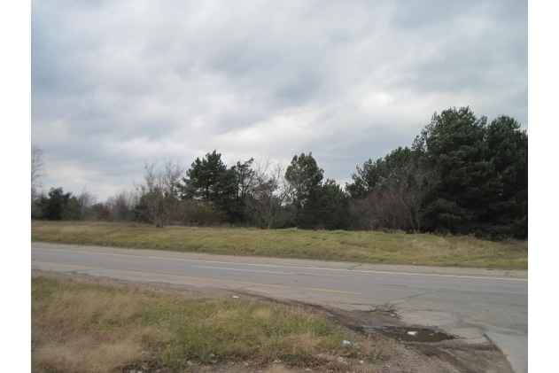
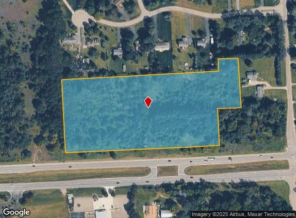
Highland Rd
08-24-400-041
SEC 24 T3N R6E, BEG AT A PT. N 412.66 FT. ALNG. E LN. OF SAID SEC. AND N89*32'49"W 295 FT. FROM THE SE COR. OF SAID SEC.; TH
Residentialacreage
Livingston
X
Michigan
26093C0250D
10.12 AC
2025
Livingston County
2025
Detroit
713100
Detroit-Warren-Dearborn, MI
DEMOGRAPHICS near Highland Rd
1 Mile
3 Mile
5 Mile
2024 Total Population
2,674
13,330
35,164
2029 Population
2,723
13,583
35,586
Pop Growth 2024-2029
+ 1.83%
+ 1.90%
+ 1.20%
Average Age
44
43
43
2024 Total Households
1,016
4,880
13,082
HH Growth 2024-2029
+ 1.87%
+ 1.76%
+ 1.12%
Median Household Inc
$68,120
$98,405
$99,808
Avg Household Size
2.60
2.70
2.60
2024 Avg HH Vehicles
2.00
2.00
2.00
Median Home Value
$283,727
$354,895
$344,383
Median Year Built
1993
1992
1989
Nearby Places
Map Layers
Map Styles
 Street
 Aerial
- Restaurants
- Banks
- Shops
- Fitness
- Groceries
PUBLIC TRANSPORTATION
AIRPORT
Bishop International
DRIVE
WALK
Distance
Bishop International
42 min
29.1 mi
Freight Ports
Port of Toledo
DRIVE
WALK
Distance
Port of Toledo
107 min
88.7 mi
SALE & LEASE HISTORY
LISTING DATE
SALE/LEASE

Sep 24, 2016
For Sale
Nearby Properties
Address
Land Use
TOTAL SIZE
Lot Size
Zoning
Address
Land Use
TOTAL SIZE
Lot Size
Zoning
75,102 SF
27.14 AC
CA
Address
Land Use
TOTAL SIZE
Lot Size
Zoning
154.38 AC
MR
Address
Land Use
TOTAL SIZE
Lot Size
Zoning
163,707 SF
17.93 AC
CA
Address
Land Use
TOTAL SIZE
Lot Size
Zoning
83,159 SF
34.44 AC
Address
Land Use
TOTAL SIZE
Lot Size
Zoning
42,134 SF
6.80 AC
CA
Address
Land Use
TOTAL SIZE
Lot Size
Zoning
7,616 SF
78.67 AC
MM
Address
Land Use
TOTAL SIZE
Lot Size
Zoning
21,758 SF
630.29 AC
I-1
Address
Land Use
TOTAL SIZE
Lot Size
Zoning
93,084 SF
9.11 AC
GC
Address
Land Use
TOTAL SIZE
Lot Size
Zoning
34,075 SF
14.06 AC
BI
Address
Land Use
TOTAL SIZE
Lot Size
Zoning
51,167 SF
11.08 AC
BI
Address
Land Use
TOTAL SIZE
Lot Size
Zoning
7,360 SF
4.95 AC
GC
Address
Land Use
TOTAL SIZE
Lot Size
Zoning
27,756 SF
228.31 AC
Address
Land Use
TOTAL SIZE
Lot Size
Zoning
47,996 SF
8.99 AC
BI
Address
Land Use
TOTAL SIZE
Lot Size
Zoning
58,721 SF
7.59 AC
BI
Address
Land Use
TOTAL SIZE
Lot Size
Zoning
3,871 SF
352.69 AC
CA
Address
Land Use
TOTAL SIZE
Lot Size
Zoning
12,636 SF
2.32 AC
OS
Address
Land Use
TOTAL SIZE
Lot Size
Zoning
15,320 SF
1.74 AC
GC
Address
Land Use
TOTAL SIZE
Lot Size
Zoning
21,000 SF
3.12 AC
BI
Address
Land Use
TOTAL SIZE
Lot Size
Zoning
14,271 SF
3.20 AC
GC
Address
Land Use
TOTAL SIZE
Lot Size
Zoning
15,105 SF
140 AC
CA
Address
Land Use
TOTAL SIZE
Lot Size
Zoning
6,623 SF
6.16 AC
OS
Address
Land Use
TOTAL SIZE
Lot Size
Zoning
4,046 SF
1.26 AC
PD
Address
Land Use
TOTAL SIZE
Lot Size
Zoning
11,024 SF
2.05 AC
GC
Address
Land Use
TOTAL SIZE
Lot Size
Zoning
6,798 SF
15.63 AC
OS
Address
Land Use
TOTAL SIZE
Lot Size
Zoning
50.93 AC
MM
Address
Land Use
TOTAL SIZE
Lot Size
Zoning
4,550 SF
1.25 AC
GC
Address
Land Use
TOTAL SIZE
Lot Size
Zoning
15,066 SF
6.39 AC
OS
Address
Land Use
TOTAL SIZE
Lot Size
Zoning
7,800 SF
2.15 AC
GC
Address
Land Use
TOTAL SIZE
Lot Size
Zoning
3,910 SF
50 AC
CA
The World's #1 Commercial Real Estate Marketplace
Connect with us
© 2025 CoStar Group
The information above has been obtained from sources believed reliable. While we do not doubt its accuracy we have not verified it and make no guarantee, warranty or representation about it. It is your responsibility to independently confirm its accuracy and completeness. Any projections, opinions, assumptions, or estimates used are for example only and do not represent the current or future performance of the property. The value of this transaction to you depends on tax and other factors which should be evaluated by your tax, financial, and legal advisors. You and your advisors should conduct a careful, independent investigation of the property to determine to your satisfaction the suitability of the property for your needs.