Property Record
Hight Rd, Waxahachie, TX 75167

Property Detail
Hight Rd
Dallas-Fort Worth-Arlington, TX
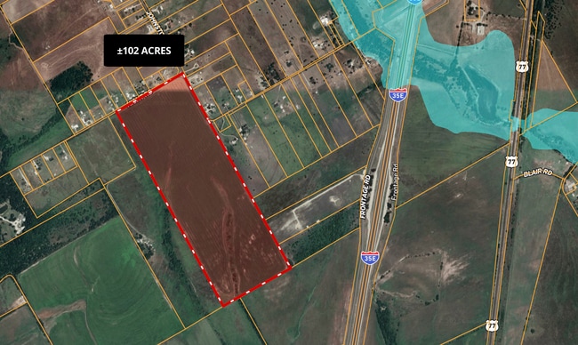
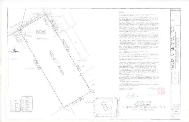
1149 S WHITE 102.027 ACRES
192447
ELLIS
Agriculturalland
Texas
B and X Area of moderate flood hazard, usually the area between the limits of the 100-year and 500-year floods.
102.03 AC
2024
Ellis County
2025
Dallas/Ft Worth
061100
NEARBY LISTINGS FOR SALE OR LEASE
DEMOGRAPHICS near Hight Rd
1 mile
3 mile
5 mile
2025 Total Population
217
1,643
4,969
2030 Population
254
1,907
5,724
Pop Growth 2025-2030
+ 17.05%
+ 16.07%
+ 15.19%
Average Age
39
41
40
2025 Total Households
70
564
1,696
HH Growth 2025-2030
+ 17.14%
+ 16.13%
+ 15.39%
Median Household Inc
$83,928
$85,655
$93,631
Avg Household Size
3.10
2.90
2.90
2025 Avg HH Vehicles
2.00
2.00
2.00
Median Home Value
$422,727
$428,070
$422,436
Median Year Built
2002
1992
1990
Nearby Places
Map Layers
Map Styles
 Street
 Aerial
Layers
 Traffic
 Biking
Places
Listings with unknown addresses are not visible on the map
- Restaurants
- Banks
- Shops
- Fitness
- Groceries
Nearby Properties
Address
Land Use
TOTAL SIZE
Lot Size
Zoning
Address
Land Use
TOTAL SIZE
Lot Size
Zoning
850 SF
56.79 AC
Address
Land Use
TOTAL SIZE
Lot Size
Zoning
74.57 AC
Address
Land Use
TOTAL SIZE
Lot Size
Zoning
28,060 SF
10.35 AC
Address
Land Use
TOTAL SIZE
Lot Size
Zoning
3,040 SF
20.91 AC
Address
Land Use
TOTAL SIZE
Lot Size
Zoning
18,680 SF
1.48 AC
Address
Land Use
TOTAL SIZE
Lot Size
Zoning
7,534 SF
21.46 AC
Address
Land Use
TOTAL SIZE
Lot Size
Zoning
7,269 SF
395.84 AC
Address
Land Use
TOTAL SIZE
Lot Size
Zoning
22,950 SF
5 AC
Address
Land Use
TOTAL SIZE
Lot Size
Zoning
48,100 SF
17.47 AC
Address
Land Use
TOTAL SIZE
Lot Size
Zoning
15,000 SF
10.01 AC
Address
Land Use
TOTAL SIZE
Lot Size
Zoning
2,678 SF
28.66 AC
Address
Land Use
TOTAL SIZE
Lot Size
Zoning
11,400 SF
5 AC
Address
Land Use
TOTAL SIZE
Lot Size
Zoning
6,804 SF
80.42 AC
Address
Land Use
TOTAL SIZE
Lot Size
Zoning
8,750 SF
10.21 AC
Address
Land Use
TOTAL SIZE
Lot Size
Zoning
3,240 SF
19.63 AC
Address
Land Use
TOTAL SIZE
Lot Size
Zoning
7,584 SF
0.75 AC
Address
Land Use
TOTAL SIZE
Lot Size
Zoning
30 AC
Address
Land Use
TOTAL SIZE
Lot Size
Zoning
1,760 SF
11.11 AC
Address
Land Use
TOTAL SIZE
Lot Size
Zoning
5,823 SF
4.98 AC
Address
Land Use
TOTAL SIZE
Lot Size
Zoning
5,242 SF
46 AC
Address
Land Use
TOTAL SIZE
Lot Size
Zoning
1,050 SF
2.41 AC
Address
Land Use
TOTAL SIZE
Lot Size
Zoning
27 AC
Address
Land Use
TOTAL SIZE
Lot Size
Zoning
3,915 SF
11.50 AC
Address
Land Use
TOTAL SIZE
Lot Size
Zoning
5,306 SF
10.15 AC
Address
Land Use
TOTAL SIZE
Lot Size
Zoning
3,265 SF
10.01 AC
Address
Land Use
TOTAL SIZE
Lot Size
Zoning
4,726 SF
24.04 AC
Address
Land Use
TOTAL SIZE
Lot Size
Zoning
7,772 SF
8.50 AC
Address
Land Use
TOTAL SIZE
Lot Size
Zoning
6,793 SF
12.88 AC
Address
Land Use
TOTAL SIZE
Lot Size
Zoning
6,305 SF
12.89 AC
Address
Land Use
TOTAL SIZE
Lot Size
Zoning
The World's #1 Commercial Real Estate Marketplace
Connect with us
© 2026 CoStar Group
The information above has been obtained from sources believed reliable. While we do not doubt its accuracy we have not verified it and make no guarantee, warranty or representation about it. It is your responsibility to independently confirm its accuracy and completeness. Any projections, opinions, assumptions, or estimates used are for example only and do not represent the current or future performance of the property. The value of this transaction to you depends on tax and other factors which should be evaluated by your tax, financial, and legal advisors. You and your advisors should conduct a careful, independent investigation of the property to determine to your satisfaction the suitability of the property for your needs.