Property Record
2985 E Hightower Trl, Conyers, GA 30012
Property Detail
2985 E Hightower Trl
061-0-01-0001
290 308 & 309 NE/SIDE HIGHTOWER
Privatepreserveopenspacevacantlandforestlandconservation
ROCKDALE
WP
Georgia
B and X Area of moderate flood hazard, usually the area between the limits of the 100-year and 500-year floods.
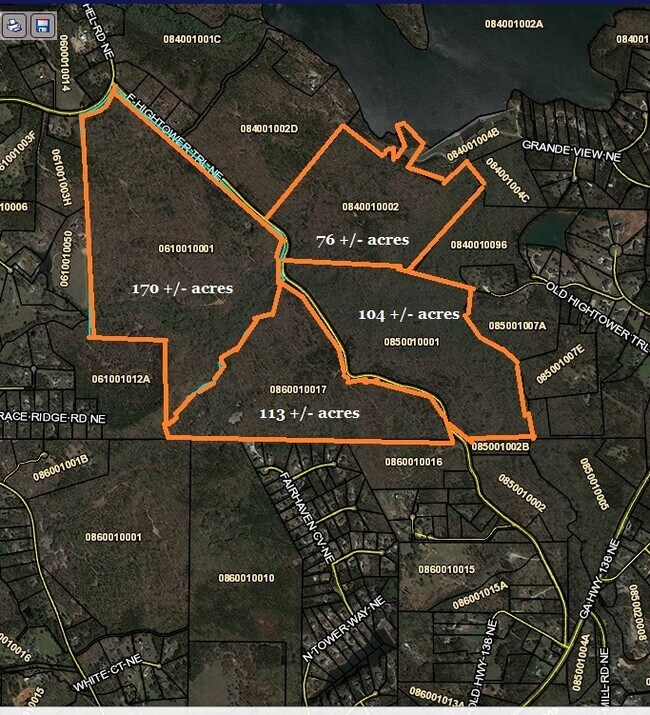
170 AC
2025
I-20 East/Conyers
2025
Atlanta
110509
Atlanta-Sandy Springs-Roswell, GA
NEARBY LISTINGS FOR SALE OR LEASE
DEMOGRAPHICS near 2985 E Hightower Trl
1 mile
3 mile
5 mile
2025 Total Population
372
8,741
40,142
2030 Population
394
9,262
42,537
Pop Growth 2025-2030
+ 5.91%
+ 5.96%
+ 5.97%
Average Age
46
41
39
2025 Total Households
145
3,128
13,807
HH Growth 2025-2030
+ 6.21%
+ 6.11%
+ 6.11%
Median Household Inc
$159,286
$109,463
$80,583
Avg Household Size
2.50
2.70
2.80
2025 Avg HH Vehicles
3.00
2.00
2.00
Median Home Value
$476,470
$329,441
$307,284
Median Year Built
1991
1992
1993
Nearby Places
Map Layers
Map Styles
 Street
 Aerial
Transit
 Traffic
 Biking
Places
Listings with unknown addresses are not visible on the map
- Restaurants
- Banks
- Shops
- Fitness
- Groceries
PUBLIC TRANSPORTATION
AIRPORT
Hartsfield - Jackson Atlanta International
Drive
Walk
Distance
Hartsfield - Jackson Atlanta International
54 min
36.4 mi
Freight Ports
Georgia Ports - Savannah
Drive
Walk
Distance
Georgia Ports - Savannah
290 min
245.3 mi
SALE & LEASE HISTORY
LISTING DATE
SALE/LEASE

Aug 17, 2022
For Sale
Nearby Properties
Address
Land Use
TOTAL SIZE
Lot Size
Zoning
Address
Land Use
TOTAL SIZE
Lot Size
Zoning
362,852 SF
18.42 AC
RM24
Address
Land Use
TOTAL SIZE
Lot Size
Zoning
7,806 SF
32.76 AC
RM
Address
Land Use
TOTAL SIZE
Lot Size
Zoning
66,181 SF
25.46 AC
R1A
Address
Land Use
TOTAL SIZE
Lot Size
Zoning
653.65 AC
WP
Address
Land Use
TOTAL SIZE
Lot Size
Zoning
5,500 SF
1.56 AC
C1
Address
Land Use
TOTAL SIZE
Lot Size
Zoning
38.50 AC
R3C2C1OI(C
Address
Land Use
TOTAL SIZE
Lot Size
Zoning
13,500 SF
1.18 AC
R1
Address
Land Use
TOTAL SIZE
Lot Size
Zoning
8,433 SF
2.18 AC
C1/C
Address
Land Use
TOTAL SIZE
Lot Size
Zoning
10,493 SF
11.96 AC
R1/R1A
Address
Land Use
TOTAL SIZE
Lot Size
Zoning
1,064 SF
4.10 AC
WP
Address
Land Use
TOTAL SIZE
Lot Size
Zoning
160 AC
WP
Address
Land Use
TOTAL SIZE
Lot Size
Zoning
221.84 AC
WP
Address
Land Use
TOTAL SIZE
Lot Size
Zoning
151.99 AC
AR
Address
Land Use
TOTAL SIZE
Lot Size
Zoning
2,480 SF
0.75 AC
WP/NCU
Address
Land Use
TOTAL SIZE
Lot Size
Zoning
4,822 SF
15.17 AC
WP
Address
Land Use
TOTAL SIZE
Lot Size
Zoning
2,040 SF
1.25 AC
WP
Address
Land Use
TOTAL SIZE
Lot Size
Zoning
117 AC
WP
Address
Land Use
TOTAL SIZE
Lot Size
Zoning
120.71 AC
WP
Address
Land Use
TOTAL SIZE
Lot Size
Zoning
58.17 AC
WP
Address
Land Use
TOTAL SIZE
Lot Size
Zoning
5,837 SF
15 AC
AR
Address
Land Use
TOTAL SIZE
Lot Size
Zoning
113.73 AC
WP
Address
Land Use
TOTAL SIZE
Lot Size
Zoning
60.27 AC
AR
Address
Land Use
TOTAL SIZE
Lot Size
Zoning
113 AC
WP
Address
Land Use
TOTAL SIZE
Lot Size
Zoning
256 SF
80.22 AC
WP
Address
Land Use
TOTAL SIZE
Lot Size
Zoning
4,093 SF
243.76 AC
AR
Address
Land Use
TOTAL SIZE
Lot Size
Zoning
104.98 AC
AR/WP
Address
Land Use
TOTAL SIZE
Lot Size
Zoning
8,098 SF
5.33 AC
WP
Address
Land Use
TOTAL SIZE
Lot Size
Zoning
92.33 AC
R1
Address
Land Use
TOTAL SIZE
Lot Size
Zoning
3,492 SF
1.72 AC
AR
The World's #1 Commercial Real Estate Marketplace
Connect with us
© 2026 CoStar Group
The information above has been obtained from sources believed reliable. While we do not doubt its accuracy we have not verified it and make no guarantee, warranty or representation about it. It is your responsibility to independently confirm its accuracy and completeness. Any projections, opinions, assumptions, or estimates used are for example only and do not represent the current or future performance of the property. The value of this transaction to you depends on tax and other factors which should be evaluated by your tax, financial, and legal advisors. You and your advisors should conduct a careful, independent investigation of the property to determine to your satisfaction the suitability of the property for your needs.