Property Record
Highway 10, Roland, AR 72135
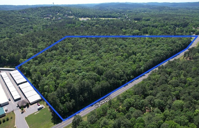

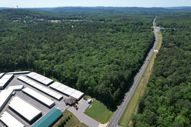
This Property Is For Sale
Property Detail
Highway 10
Little Rock-North Little Rock-Conway, AR
PT E1/2 SW COM SW COR SE SW TH N2*617W AL W LN 371 1 TO POB TH CONT N2*617W 1474 03 TH S R/W OF HWY 10 TH S59*417E AL R/W 129 6 TH S54*2719E 340 8 TH S49*5022 E AL R/W 829 6 TH S40*948W AL R/W 40 TH S49*5022E 284 2 TH S40*938W 586 22
53R-008-00-029-07
PULASKI
Agriculturalland
Arkansas
B and X Area of moderate flood hazard, usually the area between the limits of the 100-year and 500-year floods.
24.47 AC
2025
Outlying Pulaski County
2025
Little Rock/N Little Rock
004201
NEARBY LISTINGS FOR SALE OR LEASE
DEMOGRAPHICS near Highway 10
1 mile
3 mile
5 mile
2025 Total Population
863
5,155
17,086
2030 Population
874
5,199
17,190
Pop Growth 2025-2030
+ 1.27%
+ 0.85%
+ 0.61%
Average Age
44
43
43
2025 Total Households
336
2,139
6,904
HH Growth 2025-2030
+ 1.19%
+ 0.79%
+ 0.65%
Median Household Inc
$135,416
$112,763
$123,663
Avg Household Size
2.60
2.40
2.40
2025 Avg HH Vehicles
2.00
2.00
2.00
Median Home Value
$430,000
$424,784
$471,967
Median Year Built
2003
2003
2003
Nearby Places
Map Layers
Map Styles
 Street
 Aerial
Layers
 Traffic
 Biking
Places
Listings with unknown addresses are not visible on the map
- Restaurants
- Banks
- Shops
- Fitness
- Groceries
PUBLIC TRANSPORTATION
AIRPORT
Bill and Hillary Clinton Ntl/Adams Field
Drive
Walk
Distance
Bill and Hillary Clinton Ntl/Adams Field
33 min
22.2 mi
Freight Ports
Port of Shreveport
Drive
Walk
Distance
Port of Shreveport
260 min
239.6 mi
Nearby Properties
Address
Land Use
TOTAL SIZE
Lot Size
Zoning
Address
Land Use
TOTAL SIZE
Lot Size
Zoning
267,343 SF
52.19 AC
Address
Land Use
TOTAL SIZE
Lot Size
Zoning
58,828 SF
15.22 AC
Address
Land Use
TOTAL SIZE
Lot Size
Zoning
206,671 SF
26.16 AC
Address
Land Use
TOTAL SIZE
Lot Size
Zoning
173,120 SF
67.23 AC
Address
Land Use
TOTAL SIZE
Lot Size
Zoning
58,854 SF
7.11 AC
Address
Land Use
TOTAL SIZE
Lot Size
Zoning
12,469 SF
10 AC
Address
Land Use
TOTAL SIZE
Lot Size
Zoning
21.56 AC
Address
Land Use
TOTAL SIZE
Lot Size
Zoning
30,510 SF
18.76 AC
Address
Land Use
TOTAL SIZE
Lot Size
Zoning
42,015 SF
18.33 AC
Address
Land Use
TOTAL SIZE
Lot Size
Zoning
6,699 SF
7.53 AC
Address
Land Use
TOTAL SIZE
Lot Size
Zoning
73,873 SF
7.26 AC
Address
Land Use
TOTAL SIZE
Lot Size
Zoning
19,200 SF
7.25 AC
Address
Land Use
TOTAL SIZE
Lot Size
Zoning
6,429 SF
1.73 AC
Address
Land Use
TOTAL SIZE
Lot Size
Zoning
21,600 SF
2.30 AC
Address
Land Use
TOTAL SIZE
Lot Size
Zoning
15,861 SF
1.06 AC
Address
Land Use
TOTAL SIZE
Lot Size
Zoning
5,902 SF
1.73 AC
Address
Land Use
TOTAL SIZE
Lot Size
Zoning
15,698 SF
82 AC
Address
Land Use
TOTAL SIZE
Lot Size
Zoning
6.94 AC
Address
Land Use
TOTAL SIZE
Lot Size
Zoning
3,545 SF
1.41 AC
Address
Land Use
TOTAL SIZE
Lot Size
Zoning
2.97 AC
Address
Land Use
TOTAL SIZE
Lot Size
Zoning
2,302 SF
1.09 AC
Address
Land Use
TOTAL SIZE
Lot Size
Zoning
4,242 SF
1.08 AC
Address
Land Use
TOTAL SIZE
Lot Size
Zoning
8.98 AC
Address
Land Use
TOTAL SIZE
Lot Size
Zoning
12,072 SF
1.78 AC
Address
Land Use
TOTAL SIZE
Lot Size
Zoning
3,083 SF
1.08 AC
Address
Land Use
TOTAL SIZE
Lot Size
Zoning
8,648 SF
1.01 AC
Address
Land Use
TOTAL SIZE
Lot Size
Zoning
2,376 SF
2.11 AC
Address
Land Use
TOTAL SIZE
Lot Size
Zoning
280 SF
1.05 AC
Address
Land Use
TOTAL SIZE
Lot Size
Zoning
6,312 SF
6.93 AC
Address
Land Use
TOTAL SIZE
Lot Size
Zoning
6,060 SF
2.06 AC
The World's #1 Commercial Real Estate Marketplace
Connect with us
© 2026 CoStar Group
The information above has been obtained from sources believed reliable. While we do not doubt its accuracy we have not verified it and make no guarantee, warranty or representation about it. It is your responsibility to independently confirm its accuracy and completeness. Any projections, opinions, assumptions, or estimates used are for example only and do not represent the current or future performance of the property. The value of this transaction to you depends on tax and other factors which should be evaluated by your tax, financial, and legal advisors. You and your advisors should conduct a careful, independent investigation of the property to determine to your satisfaction the suitability of the property for your needs.