Property Record
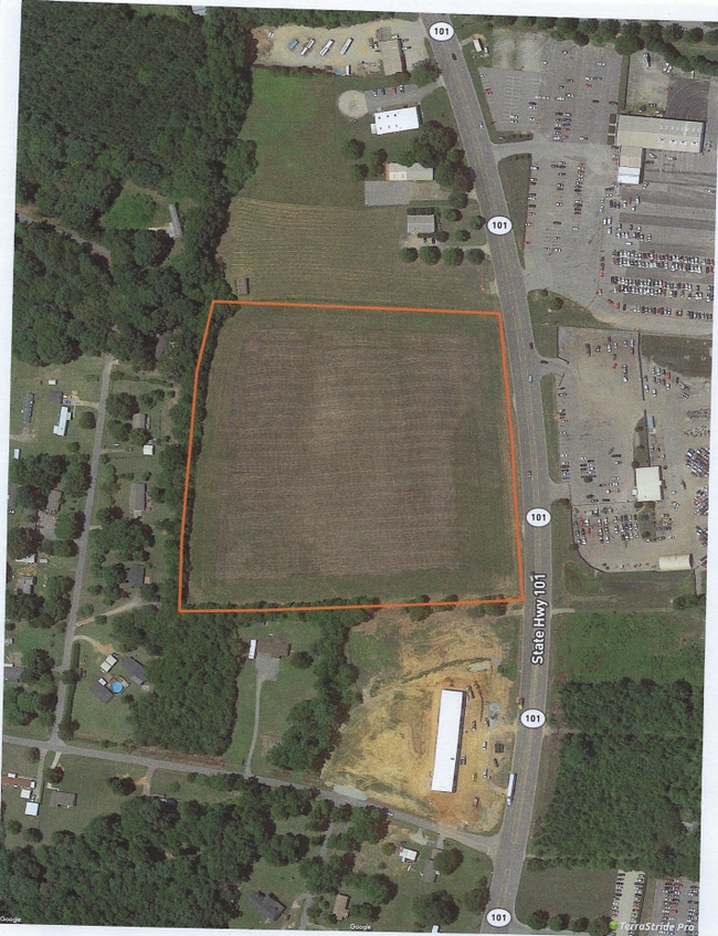
Highway 101, Greer, SC 29651

Property Detail
Highway 101
Spartanburg, SC
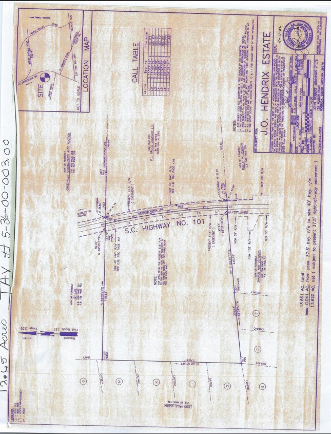
E SIDE HWY 101 S N OF REIDVILLE SHARON RD PB 178-620
4-02-00-003.04
SPARTANBURG
Residentialacreage
South Carolina
B and X Area of moderate flood hazard, usually the area between the limits of the 100-year and 500-year floods.
4.42 AC
2024
Rt 101 Corridor
2025
Greenville/Spartanburg
002505
NEARBY LISTINGS FOR SALE OR LEASE
DEMOGRAPHICS near Highway 101
1 mile
3 mile
5 mile
2025 Total Population
2,240
15,619
45,000
2030 Population
2,538
17,653
50,423
Pop Growth 2025-2030
+ 13.30%
+ 13.02%
+ 12.05%
Average Age
39
38
38
2025 Total Households
820
5,584
16,429
HH Growth 2025-2030
+ 13.29%
+ 13.11%
+ 12.16%
Median Household Inc
$91,743
$93,667
$92,695
Avg Household Size
2.70
2.80
2.70
2025 Avg HH Vehicles
3.00
2.00
2.00
Median Home Value
$325,482
$312,744
$307,157
Median Year Built
2006
2007
2004
Nearby Places
Map Layers
Map Styles
 Street
 Aerial
Transit
 Traffic
 Biking
Places
Listings with unknown addresses are not visible on the map
- Restaurants
- Banks
- Shops
- Fitness
- Groceries
PUBLIC TRANSPORTATION
AIRPORT
Greenville Spartanburg International
Drive
Walk
Distance
Greenville Spartanburg International
16 min
9.3 mi
Freight Ports
North Charleston Terminal
Drive
Walk
Distance
North Charleston Terminal
225 min
191.2 mi
SALE & LEASE HISTORY
LISTING DATE
SALE/LEASE

Sep 28, 2020
For Sale
Jan 31, 2022
For Sale
Nearby Properties
Address
Land Use
TOTAL SIZE
Lot Size
Zoning
Address
Land Use
TOTAL SIZE
Lot Size
Zoning
380,932 SF
30.39 AC
Address
Land Use
TOTAL SIZE
Lot Size
Zoning
214,064 SF
16.18 AC
Address
Land Use
TOTAL SIZE
Lot Size
Zoning
1,345 SF
115.58 AC
Address
Land Use
TOTAL SIZE
Lot Size
Zoning
430,000 SF
39.30 AC
Address
Land Use
TOTAL SIZE
Lot Size
Zoning
215,006 SF
25.51 AC
Address
Land Use
TOTAL SIZE
Lot Size
Zoning
2,713 SF
61.50 AC
Address
Land Use
TOTAL SIZE
Lot Size
Zoning
3.40 AC
RS
Address
Land Use
TOTAL SIZE
Lot Size
Zoning
1,518 SF
78.61 AC
Address
Land Use
TOTAL SIZE
Lot Size
Zoning
4,397 SF
5 AC
Address
Land Use
TOTAL SIZE
Lot Size
Zoning
4,769 SF
0.60 AC
Address
Land Use
TOTAL SIZE
Lot Size
Zoning
13,628 SF
8.80 AC
Address
Land Use
TOTAL SIZE
Lot Size
Zoning
4,060 SF
0.60 AC
Address
Land Use
TOTAL SIZE
Lot Size
Zoning
6,290 SF
Address
Land Use
TOTAL SIZE
Lot Size
Zoning
4,192 SF
0.57 AC
Address
Land Use
TOTAL SIZE
Lot Size
Zoning
4,164 SF
0.22 AC
Address
Land Use
TOTAL SIZE
Lot Size
Zoning
6,622 SF
1.44 AC
Address
Land Use
TOTAL SIZE
Lot Size
Zoning
10.08 AC
Address
Land Use
TOTAL SIZE
Lot Size
Zoning
4,304 SF
0.65 AC
Address
Land Use
TOTAL SIZE
Lot Size
Zoning
2,672 SF
99.03 AC
Address
Land Use
TOTAL SIZE
Lot Size
Zoning
2,770 SF
0.72 AC
Address
Land Use
TOTAL SIZE
Lot Size
Zoning
3,638 SF
34.85 AC
Address
Land Use
TOTAL SIZE
Lot Size
Zoning
3,423 SF
0.17 AC
Address
Land Use
TOTAL SIZE
Lot Size
Zoning
3,718 SF
0.20 AC
Address
Land Use
TOTAL SIZE
Lot Size
Zoning
4,500 SF
0.54 AC
Address
Land Use
TOTAL SIZE
Lot Size
Zoning
1,050 SF
8.53 AC
Address
Land Use
TOTAL SIZE
Lot Size
Zoning
3,566 SF
0.57 AC
Address
Land Use
TOTAL SIZE
Lot Size
Zoning
44.31 AC
Address
Land Use
TOTAL SIZE
Lot Size
Zoning
3,764 SF
0.23 AC
Address
Land Use
TOTAL SIZE
Lot Size
Zoning
3,890 SF
0.24 AC
Address
Land Use
TOTAL SIZE
Lot Size
Zoning
3,458 SF
0.15 AC
The World's #1 Commercial Real Estate Marketplace
Connect with us
© 2026 CoStar Group
The information above has been obtained from sources believed reliable. While we do not doubt its accuracy we have not verified it and make no guarantee, warranty or representation about it. It is your responsibility to independently confirm its accuracy and completeness. Any projections, opinions, assumptions, or estimates used are for example only and do not represent the current or future performance of the property. The value of this transaction to you depends on tax and other factors which should be evaluated by your tax, financial, and legal advisors. You and your advisors should conduct a careful, independent investigation of the property to determine to your satisfaction the suitability of the property for your needs.