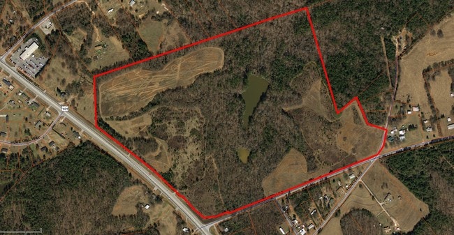
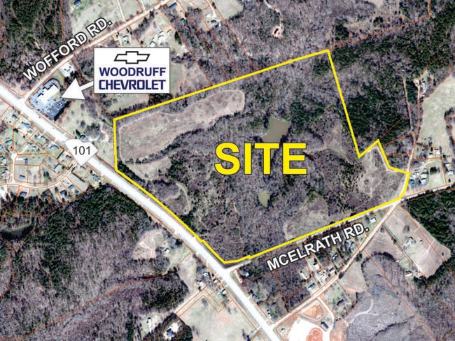
Property Record
Highway 101, Woodruff, SC 29388


Property Detail
Highway 101
Spartanburg, SC
TR 1-5 WOODRUFF 101 LAND DEVELOPENT LLC SUR R/W TAKEN 42.107B TR 110 PB 172-474 DB 132P-171 DB 132P-
4-18-00-020.00
SPARTANBURG
Residentialacreage
South Carolina
B and X Area of moderate flood hazard, usually the area between the limits of the 100-year and 500-year floods.
61.03 AC
2024
Lower Spartanburg County
2025
Greenville/Spartanburg
023500
NEARBY LISTINGS FOR SALE OR LEASE
DEMOGRAPHICS near Highway 101
1 mile
3 mile
5 mile
2025 Total Population
717
6,447
15,077
2030 Population
822
7,290
16,900
Pop Growth 2025-2030
+ 14.64%
+ 13.08%
+ 12.09%
Average Age
42
41
41
2025 Total Households
285
2,525
5,840
HH Growth 2025-2030
+ 14.74%
+ 13.15%
+ 12.26%
Median Household Inc
$81,122
$71,778
$71,737
Avg Household Size
2.40
2.50
2.50
2025 Avg HH Vehicles
3.00
2.00
2.00
Median Home Value
$237,142
$217,599
$229,297
Median Year Built
2003
1990
1992
Nearby Places
Map Layers
Map Styles
 Street
 Aerial
Transit
 Traffic
 Biking
Places
Listings with unknown addresses are not visible on the map
- Restaurants
- Banks
- Shops
- Fitness
- Groceries
PUBLIC TRANSPORTATION
AIRPORT
Greenville Spartanburg International
Drive
Walk
Distance
Greenville Spartanburg International
31 min
16.5 mi
Freight Ports
North Charleston Terminal
Drive
Walk
Distance
North Charleston Terminal
215 min
185.2 mi
SALE & LEASE HISTORY
LISTING DATE
SALE/LEASE

Sep 28, 2017
For Sale
Sep 24, 2016
For Sale
Feb 06, 2019
For Sale
Nearby Properties
Address
Land Use
TOTAL SIZE
Lot Size
Zoning
Address
Land Use
TOTAL SIZE
Lot Size
Zoning
128.91 AC
Address
Land Use
TOTAL SIZE
Lot Size
Zoning
118.46 AC
Address
Land Use
TOTAL SIZE
Lot Size
Zoning
10,326 SF
314.80 AC
Address
Land Use
TOTAL SIZE
Lot Size
Zoning
1,573 SF
38.19 AC
Address
Land Use
TOTAL SIZE
Lot Size
Zoning
5,648 SF
Address
Land Use
TOTAL SIZE
Lot Size
Zoning
13,758 SF
3.29 AC
Address
Land Use
TOTAL SIZE
Lot Size
Zoning
2,744 SF
2.18 AC
Address
Land Use
TOTAL SIZE
Lot Size
Zoning
14,155 SF
1.67 AC
Address
Land Use
TOTAL SIZE
Lot Size
Zoning
161,104 SF
5.09 AC
Address
Land Use
TOTAL SIZE
Lot Size
Zoning
2,599 SF
0.67 AC
Address
Land Use
TOTAL SIZE
Lot Size
Zoning
3,731 SF
5 AC
Address
Land Use
TOTAL SIZE
Lot Size
Zoning
2,262 SF
0.21 AC
Address
Land Use
TOTAL SIZE
Lot Size
Zoning
47.19 AC
Address
Land Use
TOTAL SIZE
Lot Size
Zoning
43,925 SF
3.46 AC
Address
Land Use
TOTAL SIZE
Lot Size
Zoning
2,748 SF
0.14 AC
Address
Land Use
TOTAL SIZE
Lot Size
Zoning
Address
Land Use
TOTAL SIZE
Lot Size
Zoning
24,145 SF
8.19 AC
Address
Land Use
TOTAL SIZE
Lot Size
Zoning
6,243 SF
7.09 AC
Address
Land Use
TOTAL SIZE
Lot Size
Zoning
12,313 SF
1.53 AC
Address
Land Use
TOTAL SIZE
Lot Size
Zoning
3,269 SF
1.61 AC
Address
Land Use
TOTAL SIZE
Lot Size
Zoning
10,874 SF
0.40 AC
Address
Land Use
TOTAL SIZE
Lot Size
Zoning
3,396 SF
0.45 AC
Address
Land Use
TOTAL SIZE
Lot Size
Zoning
2,747 SF
1.01 AC
Address
Land Use
TOTAL SIZE
Lot Size
Zoning
2,536 SF
3.45 AC
Address
Land Use
TOTAL SIZE
Lot Size
Zoning
14,574 SF
0.52 AC
Address
Land Use
TOTAL SIZE
Lot Size
Zoning
17,728 SF
1.05 AC
Address
Land Use
TOTAL SIZE
Lot Size
Zoning
3,200 SF
1.18 AC
Address
Land Use
TOTAL SIZE
Lot Size
Zoning
80.31 AC
Address
Land Use
TOTAL SIZE
Lot Size
Zoning
26.55 AC
Address
Land Use
TOTAL SIZE
Lot Size
Zoning
17,237 SF
1.85 AC
The World's #1 Commercial Real Estate Marketplace
Connect with us
© 2026 CoStar Group
The information above has been obtained from sources believed reliable. While we do not doubt its accuracy we have not verified it and make no guarantee, warranty or representation about it. It is your responsibility to independently confirm its accuracy and completeness. Any projections, opinions, assumptions, or estimates used are for example only and do not represent the current or future performance of the property. The value of this transaction to you depends on tax and other factors which should be evaluated by your tax, financial, and legal advisors. You and your advisors should conduct a careful, independent investigation of the property to determine to your satisfaction the suitability of the property for your needs.