Property Record
Highway 105 E, Cleveland, TX 77328
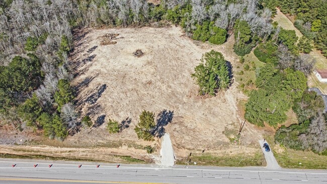

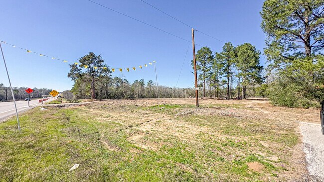
Property Detail
Highway 105 E
Houston-Pasadena-The Woodlands, TX
A0595 - WRENTMORE E, TRACT 121-A, 121-B, ACRES 3.5
0595-00-12111
MONTGOMERY
Commercialnec
Texas
B and X Area of moderate flood hazard, usually the area between the limits of the 100-year and 500-year floods.
3.50 AC
2024
Outlying Montgomery Cnty
2025
Houston
200106
NEARBY LISTINGS FOR SALE OR LEASE
DEMOGRAPHICS near Highway 105 E
1 mile
3 mile
5 mile
2025 Total Population
571
4,585
17,053
2030 Population
675
5,381
20,015
Pop Growth 2025-2030
+ 18.21%
+ 17.36%
+ 17.37%
Average Age
39
39
36
2025 Total Households
199
1,554
5,325
HH Growth 2025-2030
+ 18.09%
+ 17.89%
+ 17.92%
Median Household Inc
$57,741
$56,452
$55,246
Avg Household Size
2.80
2.90
3.10
2025 Avg HH Vehicles
2.00
2.00
2.00
Median Home Value
$369,047
$308,696
$218,113
Median Year Built
2004
2001
2003
Nearby Places
Map Layers
Map Styles
 Street
 Aerial
Layers
 Traffic
 Biking
Places
Listings with unknown addresses are not visible on the map
- Restaurants
- Banks
- Shops
- Fitness
- Groceries
PUBLIC TRANSPORTATION
AIRPORT
George Bush Intcntl/Houston
Drive
Walk
Distance
George Bush Intcntl/Houston
50 min
36.9 mi
Freight Ports
Port of Houston
Drive
Walk
Distance
Port of Houston
72 min
52.2 mi
SALE & LEASE HISTORY
LISTING DATE
SALE/LEASE

Jul 07, 2025
For Sale
Feb 20, 2024
For Lease
Nearby Properties
Address
Land Use
TOTAL SIZE
Lot Size
Zoning
Address
Land Use
TOTAL SIZE
Lot Size
Zoning
45,629 SF
29 AC
1
Address
Land Use
TOTAL SIZE
Lot Size
Zoning
50,652 SF
15 AC
1
Address
Land Use
TOTAL SIZE
Lot Size
Zoning
9,000 SF
1.15 AC
Address
Land Use
TOTAL SIZE
Lot Size
Zoning
39,356 SF
15 AC
1
Address
Land Use
TOTAL SIZE
Lot Size
Zoning
20,060 SF
7.20 AC
1
Address
Land Use
TOTAL SIZE
Lot Size
Zoning
8,252 SF
40.31 AC
1
Address
Land Use
TOTAL SIZE
Lot Size
Zoning
12,928 SF
3.55 AC
1
Address
Land Use
TOTAL SIZE
Lot Size
Zoning
33,170 SF
1.72 AC
1
Address
Land Use
TOTAL SIZE
Lot Size
Zoning
6,588 SF
3 AC
Address
Land Use
TOTAL SIZE
Lot Size
Zoning
12,844 SF
3.30 AC
1
Address
Land Use
TOTAL SIZE
Lot Size
Zoning
4,828 SF
3.39 AC
Address
Land Use
TOTAL SIZE
Lot Size
Zoning
16,260 SF
3 AC
Address
Land Use
TOTAL SIZE
Lot Size
Zoning
6,592 SF
1.92 AC
Address
Land Use
TOTAL SIZE
Lot Size
Zoning
7,389 SF
7.20 AC
1
Address
Land Use
TOTAL SIZE
Lot Size
Zoning
293.63 AC
Address
Land Use
TOTAL SIZE
Lot Size
Zoning
5,920 SF
1.01 AC
Address
Land Use
TOTAL SIZE
Lot Size
Zoning
4,300 SF
59.24 AC
Address
Land Use
TOTAL SIZE
Lot Size
Zoning
320 SF
44.10 AC
Address
Land Use
TOTAL SIZE
Lot Size
Zoning
59.05 AC
1
Address
Land Use
TOTAL SIZE
Lot Size
Zoning
2,196 SF
16.27 AC
Address
Land Use
TOTAL SIZE
Lot Size
Zoning
5,850 SF
2.44 AC
1
Address
Land Use
TOTAL SIZE
Lot Size
Zoning
2,352 SF
12.98 AC
Address
Land Use
TOTAL SIZE
Lot Size
Zoning
2,312 SF
17.55 AC
Address
Land Use
TOTAL SIZE
Lot Size
Zoning
6,370 SF
1.01 AC
1
Address
Land Use
TOTAL SIZE
Lot Size
Zoning
3,696 SF
62.24 AC
Address
Land Use
TOTAL SIZE
Lot Size
Zoning
2,803 SF
7.43 AC
The World's #1 Commercial Real Estate Marketplace
Connect with us
© 2026 CoStar Group
The information above has been obtained from sources believed reliable. While we do not doubt its accuracy we have not verified it and make no guarantee, warranty or representation about it. It is your responsibility to independently confirm its accuracy and completeness. Any projections, opinions, assumptions, or estimates used are for example only and do not represent the current or future performance of the property. The value of this transaction to you depends on tax and other factors which should be evaluated by your tax, financial, and legal advisors. You and your advisors should conduct a careful, independent investigation of the property to determine to your satisfaction the suitability of the property for your needs.