Property Record
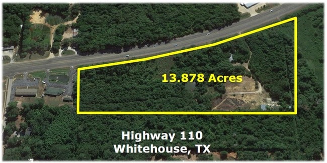
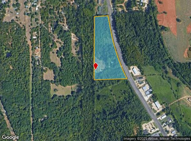
Highway 110 S, Whitehouse, TX 75791
This Property Is For Sale
NEARBY LISTINGS FOR SALE OR LEASE
Property Detail
Highway 110 S
Tyler, TX
A0858 M Sewell
1-00000-0858-00-003021
ABST A0858 M SEWELLTRACT 3B.1 (PT 13.878 AC / SEE TR 3B)
Agriculturalland
Smith
AE
Texas
48073C0075D
13.38 AC
2024
Tyler
2025
Other Market Areas
002009
DEMOGRAPHICS near Highway 110 S
1 mile
3 mile
5 mile
2024 Total Population
592
15,913
53,651
2029 Population
643
17,361
58,482
Pop Growth 2024-2029
+ 8.61%
+ 9.10%
+ 9.00%
Average Age
36
38
39
2024 Total Households
218
5,696
21,462
HH Growth 2024-2029
+ 7.80%
+ 8.51%
+ 8.48%
Median Household Inc
$59,323
$85,480
$75,204
Avg Household Size
2.70
2.70
2.40
2024 Avg HH Vehicles
2.00
2.00
2.00
Median Home Value
$181,395
$216,164
$236,223
Median Year Built
1988
1993
1989
Nearby Places
Map Layers
Map Styles
 Street
 Aerial
Transit
 Traffic
 Biking
Places
Listings with unknown addresses are not visible on the map
- Restaurants
- Banks
- Shops
- Fitness
- Groceries
PUBLIC TRANSPORTATION
AIRPORT
Tyler Pounds Regional
Drive
Walk
Distance
Tyler Pounds Regional
27 min
17.4 mi
Freight Ports
Port of Shreveport
Drive
Walk
Distance
Port of Shreveport
129 min
113.4 mi
Nearby Properties
Address
Land Use
TOTAL SIZE
Lot Size
Zoning
Address
Land Use
TOTAL SIZE
Lot Size
Zoning
49,544 SF
28.64 AC
Address
Land Use
TOTAL SIZE
Lot Size
Zoning
84,400 SF
13.98 AC
Address
Land Use
TOTAL SIZE
Lot Size
Zoning
43,165 SF
7.33 AC
Address
Land Use
TOTAL SIZE
Lot Size
Zoning
38,900 SF
20.11 AC
INT
Address
Land Use
TOTAL SIZE
Lot Size
Zoning
75,999 SF
5.09 AC
Address
Land Use
TOTAL SIZE
Lot Size
Zoning
63,737 SF
5.16 AC
Address
Land Use
TOTAL SIZE
Lot Size
Zoning
46.13 AC
Address
Land Use
TOTAL SIZE
Lot Size
Zoning
56,950 SF
4.09 AC
Address
Land Use
TOTAL SIZE
Lot Size
Zoning
2,053 SF
10.17 AC
Address
Land Use
TOTAL SIZE
Lot Size
Zoning
3,960 SF
16.27 AC
Address
Land Use
TOTAL SIZE
Lot Size
Zoning
2,592 SF
8.35 AC
Address
Land Use
TOTAL SIZE
Lot Size
Zoning
67,910 SF
7.36 AC
Address
Land Use
TOTAL SIZE
Lot Size
Zoning
59,534 SF
10 AC
PMF
Address
Land Use
TOTAL SIZE
Lot Size
Zoning
18,000 SF
24.01 AC
Address
Land Use
TOTAL SIZE
Lot Size
Zoning
4,228 SF
4.83 AC
Address
Land Use
TOTAL SIZE
Lot Size
Zoning
16,142 SF
5.40 AC
Address
Land Use
TOTAL SIZE
Lot Size
Zoning
3,552 SF
4.18 AC
Address
Land Use
TOTAL SIZE
Lot Size
Zoning
1,557 SF
5.02 AC
Address
Land Use
TOTAL SIZE
Lot Size
Zoning
18,808 SF
1.70 AC
Address
Land Use
TOTAL SIZE
Lot Size
Zoning
8,500 SF
2.97 AC
Address
Land Use
TOTAL SIZE
Lot Size
Zoning
3,864 SF
3.11 AC
Address
Land Use
TOTAL SIZE
Lot Size
Zoning
6,105 SF
2.38 AC
Address
Land Use
TOTAL SIZE
Lot Size
Zoning
19.36 AC
Address
Land Use
TOTAL SIZE
Lot Size
Zoning
9,600 SF
5.30 AC
Address
Land Use
TOTAL SIZE
Lot Size
Zoning
Address
Land Use
TOTAL SIZE
Lot Size
Zoning
7,177 SF
3.74 AC
Address
Land Use
TOTAL SIZE
Lot Size
Zoning
18,760 SF
3.34 AC
Address
Land Use
TOTAL SIZE
Lot Size
Zoning
29,395 SF
4.61 AC
Address
Land Use
TOTAL SIZE
Lot Size
Zoning
1,647 SF
14.25 AC
Address
Land Use
TOTAL SIZE
Lot Size
Zoning
2,176 SF
7 AC
The World's #1 Commercial Real Estate Marketplace
Connect with us
© 2026 CoStar Group
The information above has been obtained from sources believed reliable. While we do not doubt its accuracy we have not verified it and make no guarantee, warranty or representation about it. It is your responsibility to independently confirm its accuracy and completeness. Any projections, opinions, assumptions, or estimates used are for example only and do not represent the current or future performance of the property. The value of this transaction to you depends on tax and other factors which should be evaluated by your tax, financial, and legal advisors. You and your advisors should conduct a careful, independent investigation of the property to determine to your satisfaction the suitability of the property for your needs.