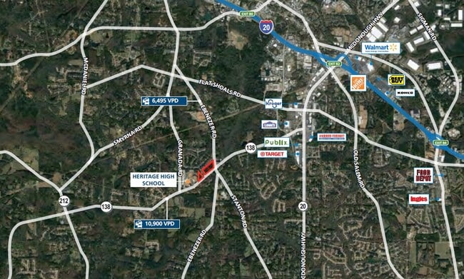
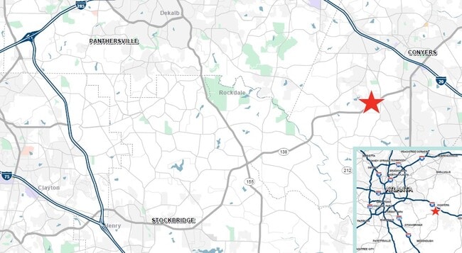
Property Record
Highway 138 Sw, Conyers, GA 30094

NEARBY LISTINGS FOR SALE OR LEASE
Property Detail
Highway 138 Sw
Atlanta-Sandy Springs-Roswell, GA
Rural
045-0-01-0018
LL209 240 LD10 11 MILITIA TOWN 476
Agriculturalland
Rockdale
X
Georgia
13247C0093D
15.99 AC
2024
I-20 East/Conyers
2024
Atlanta
060411
DEMOGRAPHICS near Highway 138 Sw
1 Mile
3 Mile
5 Mile
2024 Total Population
3,808
29,179
88,136
2029 Population
3,939
30,138
91,414
Pop Growth 2024-2029
+ 3.44%
+ 3.29%
+ 3.72%
Average Age
40
41
39
2024 Total Households
1,335
10,411
31,923
HH Growth 2024-2029
+ 3.45%
+ 3.36%
+ 3.75%
Median Household Inc
$65,869
$72,803
$67,697
Avg Household Size
2.80
2.80
2.70
2024 Avg HH Vehicles
2.00
2.00
2.00
Median Home Value
$186,036
$238,623
$217,058
Median Year Built
1987
1987
1990
Nearby Places
Map Layers
Map Styles
 Street
 Aerial
- Restaurants
- Banks
- Shops
- Fitness
- Groceries
PUBLIC TRANSPORTATION
AIRPORT
Hartsfield - Jackson Atlanta International
DRIVE
WALK
Distance
Hartsfield - Jackson Atlanta International
43 min
29.2 mi
Freight Ports
Georgia Ports - Savannah
DRIVE
WALK
Distance
Georgia Ports - Savannah
273 min
239.3 mi
SALE & LEASE HISTORY
LISTING DATE
SALE/LEASE

Mar 08, 2022
For Sale
Nearby Properties
Address
Land Use
TOTAL SIZE
Lot Size
Zoning
Address
Land Use
TOTAL SIZE
Lot Size
Zoning
22,362 SF
28.90 AC
MXD
Address
Land Use
TOTAL SIZE
Lot Size
Zoning
5,212 SF
21.33 AC
GV-UV
Address
Land Use
TOTAL SIZE
Lot Size
Zoning
8,268 SF
46.94 AC
R3
Address
Land Use
TOTAL SIZE
Lot Size
Zoning
165,171 SF
49.79 AC
BG/ID
Address
Land Use
TOTAL SIZE
Lot Size
Zoning
216,855 SF
42.21 AC
AR
Address
Land Use
TOTAL SIZE
Lot Size
Zoning
77,600 SF
9 AC
GVUV
Address
Land Use
TOTAL SIZE
Lot Size
Zoning
6,561 SF
7.49 AC
GVUV
Address
Land Use
TOTAL SIZE
Lot Size
Zoning
94,400 SF
12.50 AC
RS14
Address
Land Use
TOTAL SIZE
Lot Size
Zoning
11,600 SF
4.32 AC
GV/SU
Address
Land Use
TOTAL SIZE
Lot Size
Zoning
127,529 SF
12.89 AC
RS-14
Address
Land Use
TOTAL SIZE
Lot Size
Zoning
16,724 SF
8.33 AC
C2
Address
Land Use
TOTAL SIZE
Lot Size
Zoning
69,113 SF
7.76 AC
RS10
Address
Land Use
TOTAL SIZE
Lot Size
Zoning
27,111 SF
8.58 AC
MXD
Address
Land Use
TOTAL SIZE
Lot Size
Zoning
93,513 SF
11.03 AC
GVUV
Address
Land Use
TOTAL SIZE
Lot Size
Zoning
109,500 SF
6.79 AC
M1
Address
Land Use
TOTAL SIZE
Lot Size
Zoning
69,417 SF
13.85 AC
C1/C
Address
Land Use
TOTAL SIZE
Lot Size
Zoning
138,046 SF
18.48 AC
C2/C
Address
Land Use
TOTAL SIZE
Lot Size
Zoning
69,186 SF
2.49 AC
MXD
Address
Land Use
TOTAL SIZE
Lot Size
Zoning
134,309 SF
10.39 AC
GVUV
Address
Land Use
TOTAL SIZE
Lot Size
Zoning
5,824 SF
5.87 AC
MXD
Address
Land Use
TOTAL SIZE
Lot Size
Zoning
29.26 AC
R1
Address
Land Use
TOTAL SIZE
Lot Size
Zoning
113,548 SF
15 AC
AR
Address
Land Use
TOTAL SIZE
Lot Size
Zoning
27,081 SF
2.50 AC
ID
Address
Land Use
TOTAL SIZE
Lot Size
Zoning
52,778 SF
7.61 AC
HSB
Address
Land Use
TOTAL SIZE
Lot Size
Zoning
4,608 SF
9.15 AC
R3
Address
Land Use
TOTAL SIZE
Lot Size
Zoning
48,179 SF
1.52 AC
HSB
Address
Land Use
TOTAL SIZE
Lot Size
Zoning
49,440 SF
1.95 AC
HSB
Address
Land Use
TOTAL SIZE
Lot Size
Zoning
43,430 SF
4.05 AC
GVUV
Address
Land Use
TOTAL SIZE
Lot Size
Zoning
60,394 SF
2.33 AC
MXD
Address
Land Use
TOTAL SIZE
Lot Size
Zoning
38,604 SF
0.83 AC
C2
The World's #1 Commercial Real Estate Marketplace
Connect with us
© 2025 CoStar Group
The information above has been obtained from sources believed reliable. While we do not doubt its accuracy we have not verified it and make no guarantee, warranty or representation about it. It is your responsibility to independently confirm its accuracy and completeness. Any projections, opinions, assumptions, or estimates used are for example only and do not represent the current or future performance of the property. The value of this transaction to you depends on tax and other factors which should be evaluated by your tax, financial, and legal advisors. You and your advisors should conduct a careful, independent investigation of the property to determine to your satisfaction the suitability of the property for your needs.