Property Record
Highway 142, Maxwell, TX 78656
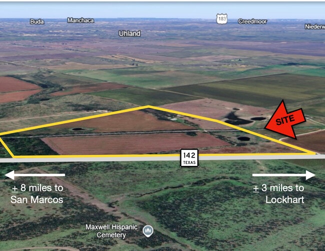
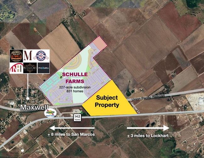
This Property Is For Sale
Property Detail
Highway 142
Austin-Round Rock-San Marcos, TX
A205 MCFERRIN, MARTIN, ACRES 7.789
11822
CALDWELL
Agriculturalland
Texas
A Areas with a 1% annual chance of flooding and a 26% chance of flooding over the life of a 30-year mortgage.
43 AC
2025
Caldwell County
2025
Austin
960502
NEARBY LISTINGS FOR SALE OR LEASE
DEMOGRAPHICS near Highway 142
1 mile
3 mile
5 mile
2024 Total Population
145
971
9,209
2029 Population
164
1,103
10,768
Pop Growth 2024-2029
+ 13.10%
+ 13.59%
+ 16.93%
Average Age
40
40
38
2024 Total Households
53
343
3,102
HH Growth 2024-2029
+ 15.09%
+ 14.58%
+ 17.70%
Median Household Inc
$84,375
$81,048
$81,171
Avg Household Size
2.70
2.70
2.90
2024 Avg HH Vehicles
3.00
3.00
3.00
Median Home Value
$289,999
$370,588
$277,798
Median Year Built
1994
1995
2004
Nearby Places
Map Layers
Map Styles
 Street
 Aerial
Transit
 Traffic
 Biking
Places
Listings with unknown addresses are not visible on the map
- Restaurants
- Banks
- Shops
- Fitness
- Groceries
PUBLIC TRANSPORTATION
AIRPORT
Austin-Bergstrom International
Drive
Walk
Distance
Austin-Bergstrom International
36 min
28.5 mi
Freight Ports
Calhoun Port
Drive
Walk
Distance
Calhoun Port
159 min
133.1 mi
Nearby Properties
Address
Land Use
TOTAL SIZE
Lot Size
Zoning
Address
Land Use
TOTAL SIZE
Lot Size
Zoning
171,520 SF
31.01 AC
Address
Land Use
TOTAL SIZE
Lot Size
Zoning
1,600 SF
49.26 AC
Address
Land Use
TOTAL SIZE
Lot Size
Zoning
68,590 SF
34.95 AC
Address
Land Use
TOTAL SIZE
Lot Size
Zoning
13,956 SF
49.65 AC
Address
Land Use
TOTAL SIZE
Lot Size
Zoning
4.47 AC
Address
Land Use
TOTAL SIZE
Lot Size
Zoning
3,284 SF
4 AC
Address
Land Use
TOTAL SIZE
Lot Size
Zoning
396 SF
9.55 AC
Address
Land Use
TOTAL SIZE
Lot Size
Zoning
340.37 AC
Address
Land Use
TOTAL SIZE
Lot Size
Zoning
4,980 SF
19.46 AC
Address
Land Use
TOTAL SIZE
Lot Size
Zoning
32.65 AC
Address
Land Use
TOTAL SIZE
Lot Size
Zoning
Address
Land Use
TOTAL SIZE
Lot Size
Zoning
12,432 SF
1 AC
Address
Land Use
TOTAL SIZE
Lot Size
Zoning
5,474 SF
2 AC
Address
Land Use
TOTAL SIZE
Lot Size
Zoning
3,400 SF
2.40 AC
Address
Land Use
TOTAL SIZE
Lot Size
Zoning
6,300 SF
2.54 AC
Address
Land Use
TOTAL SIZE
Lot Size
Zoning
22.73 AC
Address
Land Use
TOTAL SIZE
Lot Size
Zoning
2,574 SF
2.03 AC
Address
Land Use
TOTAL SIZE
Lot Size
Zoning
3,000 SF
4 AC
Address
Land Use
TOTAL SIZE
Lot Size
Zoning
4,267 SF
8.35 AC
Address
Land Use
TOTAL SIZE
Lot Size
Zoning
8,323 SF
1.59 AC
Address
Land Use
TOTAL SIZE
Lot Size
Zoning
1,778 SF
5.03 AC
Address
Land Use
TOTAL SIZE
Lot Size
Zoning
3,159 SF
11.95 AC
Address
Land Use
TOTAL SIZE
Lot Size
Zoning
Address
Land Use
TOTAL SIZE
Lot Size
Zoning
Address
Land Use
TOTAL SIZE
Lot Size
Zoning
Address
Land Use
TOTAL SIZE
Lot Size
Zoning
1,536 SF
5.05 AC
Address
Land Use
TOTAL SIZE
Lot Size
Zoning
1,388 SF
3 AC
Address
Land Use
TOTAL SIZE
Lot Size
Zoning
11.12 AC
Address
Land Use
TOTAL SIZE
Lot Size
Zoning
7.78 AC
Address
Land Use
TOTAL SIZE
Lot Size
Zoning
10.01 AC
The World's #1 Commercial Real Estate Marketplace
Connect with us
© 2026 CoStar Group
The information above has been obtained from sources believed reliable. While we do not doubt its accuracy we have not verified it and make no guarantee, warranty or representation about it. It is your responsibility to independently confirm its accuracy and completeness. Any projections, opinions, assumptions, or estimates used are for example only and do not represent the current or future performance of the property. The value of this transaction to you depends on tax and other factors which should be evaluated by your tax, financial, and legal advisors. You and your advisors should conduct a careful, independent investigation of the property to determine to your satisfaction the suitability of the property for your needs.