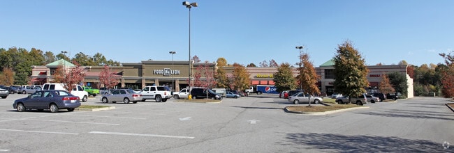
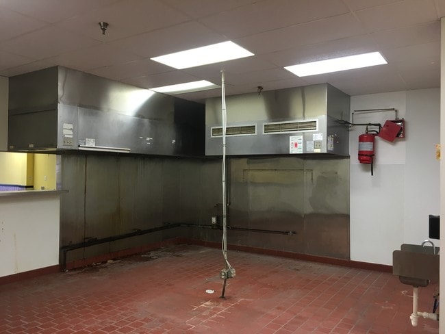
Property Record
Highway 15 S, Sumter, SC 29150

Property Detail
Highway 15 S
225-00-03-018
P92-78 2000-55 2000-5 17.13 AC -
Financialbuilding
SUMTER
G-C
South Carolina
AE The base floodplain where base flood elevations are provided. AE Zones are now used on new format FIRMs instead of A1-A30 Zones.
17.13 AC
2023
Orangeburg/Sumter
2025
Other Market Areas
001300
Sumter, SC
65,634 SF
NEARBY LISTINGS FOR SALE OR LEASE
-
-
View all Sumter listings for lease on LoopNet.com
DEMOGRAPHICS near Highway 15 S
1 mile
3 mile
5 mile
2025 Total Population
1,962
16,428
43,756
2030 Population
1,921
16,344
43,412
Pop Growth 2025-2030
(2.09%)
(0.51%)
(0.79%)
Average Age
38
40
40
2025 Total Households
765
6,599
17,554
HH Growth 2025-2030
(1.96%)
(0.38%)
(0.65%)
Median Household Inc
$53,291
$52,344
$54,351
Avg Household Size
2.60
2.40
2.40
2025 Avg HH Vehicles
2.00
2.00
2.00
Median Home Value
$276,898
$165,542
$179,828
Median Year Built
1990
1985
1982
Nearby Places
Map Layers
Map Styles
 Street
 Aerial
Layers
 Traffic
 Biking
Places
Listings with unknown addresses are not visible on the map
- Restaurants
- Banks
- Shops
- Fitness
- Groceries
SALE & LEASE HISTORY
LISTING DATE
SALE/LEASE

Sep 25, 2016
For Lease
Nearby Properties
Address
Land Use
TOTAL SIZE
Lot Size
Zoning
Address
Land Use
TOTAL SIZE
Lot Size
Zoning
11,600 SF
162 AC
Address
Land Use
TOTAL SIZE
Lot Size
Zoning
1 SF
126.83 AC
Address
Land Use
TOTAL SIZE
Lot Size
Zoning
1 SF
572.52 AC
GC
Address
Land Use
TOTAL SIZE
Lot Size
Zoning
85,300 SF
8.25 AC
Address
Land Use
TOTAL SIZE
Lot Size
Zoning
82,571 SF
18 AC
Address
Land Use
TOTAL SIZE
Lot Size
Zoning
1 SF
19.98 AC
Address
Land Use
TOTAL SIZE
Lot Size
Zoning
100,912 SF
24.99 AC
Address
Land Use
TOTAL SIZE
Lot Size
Zoning
1 SF
32.43 AC
Address
Land Use
TOTAL SIZE
Lot Size
Zoning
1 SF
66 AC
GC
Address
Land Use
TOTAL SIZE
Lot Size
Zoning
1 SF
20.10 AC
Address
Land Use
TOTAL SIZE
Lot Size
Zoning
28,919 SF
14.40 AC
R-15
Address
Land Use
TOTAL SIZE
Lot Size
Zoning
269.90 AC
Address
Land Use
TOTAL SIZE
Lot Size
Zoning
25,908 SF
4.92 AC
R
Address
Land Use
TOTAL SIZE
Lot Size
Zoning
119,418 SF
10 AC
Address
Land Use
TOTAL SIZE
Lot Size
Zoning
39,223 SF
7.47 AC
B-1
Address
Land Use
TOTAL SIZE
Lot Size
Zoning
175,617 SF
24.89 AC
COMM
Address
Land Use
TOTAL SIZE
Lot Size
Zoning
11,086 SF
2.46 AC
MFR
Address
Land Use
TOTAL SIZE
Lot Size
Zoning
1 SF
24.17 AC
Address
Land Use
TOTAL SIZE
Lot Size
Zoning
17,529 SF
4.03 AC
I-1
Address
Land Use
TOTAL SIZE
Lot Size
Zoning
1 SF
29.53 AC
Address
Land Use
TOTAL SIZE
Lot Size
Zoning
96.29 AC
Address
Land Use
TOTAL SIZE
Lot Size
Zoning
1 SF
12.64 AC
Address
Land Use
TOTAL SIZE
Lot Size
Zoning
18,394 SF
9.30 AC
R-2
Address
Land Use
TOTAL SIZE
Lot Size
Zoning
1 SF
11.55 AC
Address
Land Use
TOTAL SIZE
Lot Size
Zoning
318,797 SF
21.72 AC
Address
Land Use
TOTAL SIZE
Lot Size
Zoning
17,444 SF
3.50 AC
Address
Land Use
TOTAL SIZE
Lot Size
Zoning
8,426 SF
9.17 AC
R-1
Address
Land Use
TOTAL SIZE
Lot Size
Zoning
85,000 SF
28.61 AC
Address
Land Use
TOTAL SIZE
Lot Size
Zoning
135.77 AC
Address
Land Use
TOTAL SIZE
Lot Size
Zoning
10.11 AC
The World's #1 Commercial Real Estate Marketplace
Connect with us
© 2026 CoStar Group
The information above has been obtained from sources believed reliable. While we do not doubt its accuracy we have not verified it and make no guarantee, warranty or representation about it. It is your responsibility to independently confirm its accuracy and completeness. Any projections, opinions, assumptions, or estimates used are for example only and do not represent the current or future performance of the property. The value of this transaction to you depends on tax and other factors which should be evaluated by your tax, financial, and legal advisors. You and your advisors should conduct a careful, independent investigation of the property to determine to your satisfaction the suitability of the property for your needs.