Property Record
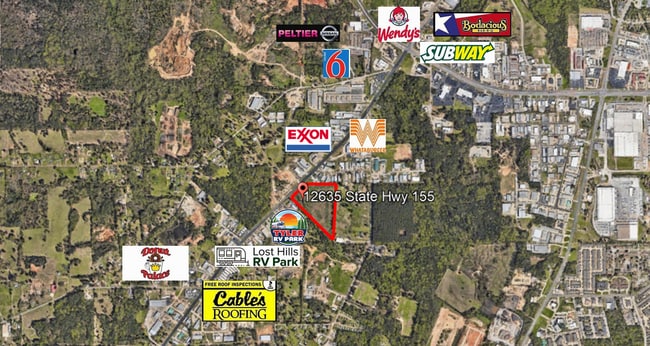
Highway 155, Tyler, TX 75703

Save to a Folder
{{folder.Name}}
{{folder.ListingIds.length}} Properties
{{folder.ListingIds.length}} Property
Create a New Folder
This Property Is For Sale
Property Detail
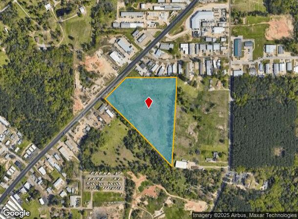
Highway 155
Tyler, TX
ABST A0030 O ANDERSONTRACT 32F
1-00000-0030-00-032060
SMITH
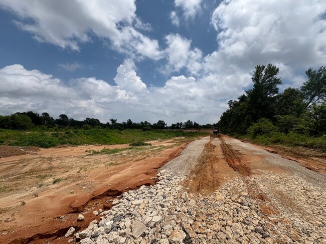
Commercialacreage
Texas
B and X Area of moderate flood hazard, usually the area between the limits of the 100-year and 500-year floods.
16.48 AC
2025
Tyler
2025
Other Market Areas
002012
NEARBY LISTINGS FOR SALE OR LEASE
DEMOGRAPHICS near Highway 155
1 mile
3 mile
5 mile
2025 Total Population
732
33,216
98,849
2030 Population
793
34,897
103,964
Pop Growth 2025-2030
+ 8.33%
+ 5.06%
+ 5.17%
Average Age
42
41
39
2025 Total Households
275
14,625
39,111
HH Growth 2025-2030
+ 8.36%
+ 4.42%
+ 4.62%
Median Household Inc
$65,660
$68,712
$68,013
Avg Household Size
2.50
2.20
2.40
2025 Avg HH Vehicles
2.00
2.00
2.00
Median Home Value
$473,333
$325,023
$270,858
Median Year Built
2001
1989
1981
Nearby Places
Map Layers
Map Styles
 Street
 Aerial
Layers
 Traffic
 Biking
Places
Listings with unknown addresses are not visible on the map
- Restaurants
- Banks
- Shops
- Fitness
- Groceries
PUBLIC TRANSPORTATION
AIRPORT
Tyler Pounds Regional
Drive
Walk
Distance
Tyler Pounds Regional
16 min
9.3 mi
Freight Ports
Port of Shreveport
Drive
Walk
Distance
Port of Shreveport
127 min
113.0 mi
Nearby Properties
Address
Land Use
TOTAL SIZE
Lot Size
Zoning
Address
Land Use
TOTAL SIZE
Lot Size
Zoning
403,396 SF
45.40 AC
C4
Address
Land Use
TOTAL SIZE
Lot Size
Zoning
278 SF
22.07 AC
PMF
Address
Land Use
TOTAL SIZE
Lot Size
Zoning
2,500 SF
19.76 AC
RMF
Address
Land Use
TOTAL SIZE
Lot Size
Zoning
24.83 AC
Address
Land Use
TOTAL SIZE
Lot Size
Zoning
29.58 AC
Address
Land Use
TOTAL SIZE
Lot Size
Zoning
14,504 SF
16.68 AC
Address
Land Use
TOTAL SIZE
Lot Size
Zoning
5,068 SF
18.35 AC
RMF
Address
Land Use
TOTAL SIZE
Lot Size
Zoning
71,337 SF
15.70 AC
M1
Address
Land Use
TOTAL SIZE
Lot Size
Zoning
4,333 SF
13.32 AC
Address
Land Use
TOTAL SIZE
Lot Size
Zoning
2,774 SF
16.15 AC
RMF
Address
Land Use
TOTAL SIZE
Lot Size
Zoning
3,724 SF
33.26 AC
RMF
Address
Land Use
TOTAL SIZE
Lot Size
Zoning
53,412 SF
11.17 AC
PMF
Address
Land Use
TOTAL SIZE
Lot Size
Zoning
66.86 AC
R1A
Address
Land Use
TOTAL SIZE
Lot Size
Zoning
10.51 AC
Address
Land Use
TOTAL SIZE
Lot Size
Zoning
88,964 SF
11.33 AC
Address
Land Use
TOTAL SIZE
Lot Size
Zoning
1,867 SF
13.63 AC
RMF
Address
Land Use
TOTAL SIZE
Lot Size
Zoning
1,920 SF
12.04 AC
RMF
Address
Land Use
TOTAL SIZE
Lot Size
Zoning
126.94 AC
Address
Land Use
TOTAL SIZE
Lot Size
Zoning
1,813 SF
9.51 AC
RMF
Address
Land Use
TOTAL SIZE
Lot Size
Zoning
90,410 SF
4.94 AC
Address
Land Use
TOTAL SIZE
Lot Size
Zoning
3,806 SF
18.86 AC
RMF
Address
Land Use
TOTAL SIZE
Lot Size
Zoning
3,477 SF
9.56 AC
RMF
Address
Land Use
TOTAL SIZE
Lot Size
Zoning
2,936 SF
9.66 AC
RMF
Address
Land Use
TOTAL SIZE
Lot Size
Zoning
82,385 SF
7.11 AC
C1
Address
Land Use
TOTAL SIZE
Lot Size
Zoning
52,557 SF
11.44 AC
RMF
Address
Land Use
TOTAL SIZE
Lot Size
Zoning
4,478 SF
9.06 AC
RMF
Address
Land Use
TOTAL SIZE
Lot Size
Zoning
4,096 SF
8.90 AC
RMF
Address
Land Use
TOTAL SIZE
Lot Size
Zoning
19.16 AC
Address
Land Use
TOTAL SIZE
Lot Size
Zoning
105,407 SF
6.14 AC
C4
Address
Land Use
TOTAL SIZE
Lot Size
Zoning
15,400 SF
4.41 AC
RMF
The World's #1 Commercial Real Estate Marketplace
Connect with us
© 2026 CoStar Group
The information above has been obtained from sources believed reliable. While we do not doubt its accuracy we have not verified it and make no guarantee, warranty or representation about it. It is your responsibility to independently confirm its accuracy and completeness. Any projections, opinions, assumptions, or estimates used are for example only and do not represent the current or future performance of the property. The value of this transaction to you depends on tax and other factors which should be evaluated by your tax, financial, and legal advisors. You and your advisors should conduct a careful, independent investigation of the property to determine to your satisfaction the suitability of the property for your needs.