Property Record
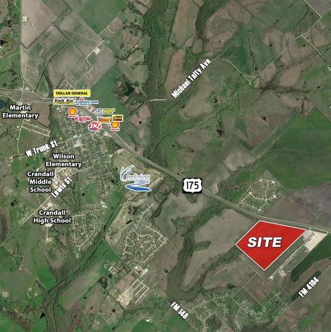
Highway 175, Crandall, TX 75114
NEARBY LISTINGS FOR SALE OR LEASE
Property Detail
Highway 175
Dallas/Ft Worth
S Gilleland
Dallas-Fort Worth-Arlington, TX
S GILLELAND, TRACT 70.00; 60.0469 ACRES
6154
Kaufman
Agriculturalland
Texas
2024
47.20 AC
2025
Mesquite/Forney/Terrell
050802
DEMOGRAPHICS near Highway 175
1 Mile
3 Mile
5 Mile
2024 Total Population
871
7,231
16,288
2029 Population
1,266
10,545
23,905
Pop Growth 2024-2029
+ 45.35%
+ 45.83%
+ 46.76%
Average Age
36
35
34
2024 Total Households
280
2,296
5,167
HH Growth 2024-2029
+ 45.00%
+ 45.21%
+ 46.16%
Median Household Inc
$65,670
$73,437
$77,912
Avg Household Size
3.10
3.10
3.10
2024 Avg HH Vehicles
2.00
3.00
2.00
Median Home Value
$200,781
$262,473
$269,738
Median Year Built
1999
2001
2007
Nearby Places
Map Layers
Map Styles
 Street
 Aerial
- Restaurants
- Banks
- Shops
- Fitness
- Groceries
PUBLIC TRANSPORTATION
AIRPORT
Dallas Love Field
DRIVE
WALK
Distance
Dallas Love Field
47 min
34.3 mi
Freight Ports
Port of Shreveport
DRIVE
WALK
Distance
Port of Shreveport
196 min
180.0 mi
SALE & LEASE HISTORY
LISTING DATE
SALE/LEASE

Jun 29, 2017
For Sale
Nearby Properties
Address
Land Use
TOTAL SIZE
Lot Size
Zoning
Address
Land Use
TOTAL SIZE
Lot Size
Zoning
195,853 SF
27.62 AC
Address
Land Use
TOTAL SIZE
Lot Size
Zoning
1,600 SF
31 AC
Address
Land Use
TOTAL SIZE
Lot Size
Zoning
76,793 SF
20.86 AC
Address
Land Use
TOTAL SIZE
Lot Size
Zoning
12,075 SF
5 AC
Address
Land Use
TOTAL SIZE
Lot Size
Zoning
Address
Land Use
TOTAL SIZE
Lot Size
Zoning
18,375 SF
0.69 AC
Address
Land Use
TOTAL SIZE
Lot Size
Zoning
11.83 AC
Address
Land Use
TOTAL SIZE
Lot Size
Zoning
12.52 AC
Address
Land Use
TOTAL SIZE
Lot Size
Zoning
144 SF
46.45 AC
Address
Land Use
TOTAL SIZE
Lot Size
Zoning
12,818 SF
0.70 AC
Address
Land Use
TOTAL SIZE
Lot Size
Zoning
9,377 SF
31.58 AC
Address
Land Use
TOTAL SIZE
Lot Size
Zoning
1,840 SF
57.21 AC
Address
Land Use
TOTAL SIZE
Lot Size
Zoning
1,511 SF
11.19 AC
Address
Land Use
TOTAL SIZE
Lot Size
Zoning
132.01 AC
Address
Land Use
TOTAL SIZE
Lot Size
Zoning
4.08 AC
Address
Land Use
TOTAL SIZE
Lot Size
Zoning
6,984 SF
2 AC
Address
Land Use
TOTAL SIZE
Lot Size
Zoning
134.58 AC
Address
Land Use
TOTAL SIZE
Lot Size
Zoning
9,900 SF
1.16 AC
Address
Land Use
TOTAL SIZE
Lot Size
Zoning
16,870 SF
1.17 AC
Address
Land Use
TOTAL SIZE
Lot Size
Zoning
6,600 SF
98.29 AC
Address
Land Use
TOTAL SIZE
Lot Size
Zoning
9,419 SF
2.34 AC
Address
Land Use
TOTAL SIZE
Lot Size
Zoning
Address
Land Use
TOTAL SIZE
Lot Size
Zoning
8,000 SF
31.58 AC
Address
Land Use
TOTAL SIZE
Lot Size
Zoning
8.47 AC
Address
Land Use
TOTAL SIZE
Lot Size
Zoning
7.97 AC
Address
Land Use
TOTAL SIZE
Lot Size
Zoning
7,218 SF
10.78 AC
Address
Land Use
TOTAL SIZE
Lot Size
Zoning
5,088 SF
1.50 AC
Address
Land Use
TOTAL SIZE
Lot Size
Zoning
5,400 SF
0.43 AC
Address
Land Use
TOTAL SIZE
Lot Size
Zoning
1.03 AC
The World's #1 Commercial Real Estate Marketplace
Connect with us
© 2026 CoStar Group
The information above has been obtained from sources believed reliable. While we do not doubt its accuracy we have not verified it and make no guarantee, warranty or representation about it. It is your responsibility to independently confirm its accuracy and completeness. Any projections, opinions, assumptions, or estimates used are for example only and do not represent the current or future performance of the property. The value of this transaction to you depends on tax and other factors which should be evaluated by your tax, financial, and legal advisors. You and your advisors should conduct a careful, independent investigation of the property to determine to your satisfaction the suitability of the property for your needs.