Property Record
Highway 178 E, Tupelo, MS 38804
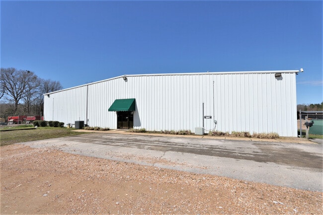

Property Detail
Highway 178 E
087U-35-002-00
PT W1/2 NW1/4
Storebuilding
LEE
AE The base floodplain where base flood elevations are provided. AE Zones are now used on new format FIRMs instead of A1-A30 Zones.
Mississippi
2025
14.50 AC
2025
Tupelo/North Area
950500
Other Market Areas
12,500 SF
Tupelo, MS
NEARBY LISTINGS FOR SALE OR LEASE
-
-
View all Tupelo listings for sale on LoopNet.com
DEMOGRAPHICS near Highway 178 E
1 mile
3 mile
5 mile
2025 Total Population
522
6,681
23,731
2030 Population
522
6,694
23,892
Pop Growth 2025-2030
0.00%
+ 0.19%
+ 0.68%
Average Age
40
40
39
2025 Total Households
201
2,590
9,716
HH Growth 2025-2030
0.00%
+ 0.27%
+ 0.75%
Median Household Inc
$96,874
$76,528
$62,727
Avg Household Size
2.40
2.40
2.30
2025 Avg HH Vehicles
2.00
2.00
2.00
Median Home Value
$181,617
$177,038
$188,120
Median Year Built
1988
1983
1977
Nearby Places
Map Layers
Map Styles
 Street
 Aerial
Transit
 Traffic
 Biking
Places
Listings with unknown addresses are not visible on the map
- Restaurants
- Banks
- Shops
- Fitness
- Groceries
SALE & LEASE HISTORY
LISTING DATE
SALE/LEASE

Apr 08, 2020
For Sale
Nearby Properties
Address
Land Use
TOTAL SIZE
Lot Size
Zoning
Address
Land Use
TOTAL SIZE
Lot Size
Zoning
64,064 SF
27.70 AC
Address
Land Use
TOTAL SIZE
Lot Size
Zoning
166,750 SF
15 AC
Address
Land Use
TOTAL SIZE
Lot Size
Zoning
15,653 SF
2.10 AC
Address
Land Use
TOTAL SIZE
Lot Size
Zoning
5,620 SF
2 AC
Address
Land Use
TOTAL SIZE
Lot Size
Zoning
75,108 SF
7.40 AC
Address
Land Use
TOTAL SIZE
Lot Size
Zoning
148,311 SF
16.80 AC
Address
Land Use
TOTAL SIZE
Lot Size
Zoning
5,646 SF
3.10 AC
Address
Land Use
TOTAL SIZE
Lot Size
Zoning
35,378 SF
4 AC
Address
Land Use
TOTAL SIZE
Lot Size
Zoning
37,318 SF
3.53 AC
Address
Land Use
TOTAL SIZE
Lot Size
Zoning
3,948 SF
3.30 AC
Address
Land Use
TOTAL SIZE
Lot Size
Zoning
8,000 SF
16 AC
Address
Land Use
TOTAL SIZE
Lot Size
Zoning
2,384 SF
0.95 AC
Address
Land Use
TOTAL SIZE
Lot Size
Zoning
20,800 SF
3.60 AC
Address
Land Use
TOTAL SIZE
Lot Size
Zoning
3,370 SF
0.51 AC
Address
Land Use
TOTAL SIZE
Lot Size
Zoning
7,292 SF
0.91 AC
Address
Land Use
TOTAL SIZE
Lot Size
Zoning
3,570 SF
1.56 AC
Address
Land Use
TOTAL SIZE
Lot Size
Zoning
32,000 SF
5.50 AC
Address
Land Use
TOTAL SIZE
Lot Size
Zoning
36,213 SF
6 AC
Address
Land Use
TOTAL SIZE
Lot Size
Zoning
3,156 SF
0.88 AC
Address
Land Use
TOTAL SIZE
Lot Size
Zoning
22,406 SF
1.86 AC
Address
Land Use
TOTAL SIZE
Lot Size
Zoning
3,200 SF
0.53 AC
Address
Land Use
TOTAL SIZE
Lot Size
Zoning
5,062 SF
1.20 AC
Address
Land Use
TOTAL SIZE
Lot Size
Zoning
17 AC
Address
Land Use
TOTAL SIZE
Lot Size
Zoning
18,375 SF
5.50 AC
Address
Land Use
TOTAL SIZE
Lot Size
Zoning
2,279 SF
1.28 AC
Address
Land Use
TOTAL SIZE
Lot Size
Zoning
40,500 SF
3.90 AC
Address
Land Use
TOTAL SIZE
Lot Size
Zoning
3,617 SF
1.51 AC
Address
Land Use
TOTAL SIZE
Lot Size
Zoning
21,982 SF
7.64 AC
Address
Land Use
TOTAL SIZE
Lot Size
Zoning
8,234 SF
1.70 AC
The World's #1 Commercial Real Estate Marketplace
Connect with us
© 2026 CoStar Group
The information above has been obtained from sources believed reliable. While we do not doubt its accuracy we have not verified it and make no guarantee, warranty or representation about it. It is your responsibility to independently confirm its accuracy and completeness. Any projections, opinions, assumptions, or estimates used are for example only and do not represent the current or future performance of the property. The value of this transaction to you depends on tax and other factors which should be evaluated by your tax, financial, and legal advisors. You and your advisors should conduct a careful, independent investigation of the property to determine to your satisfaction the suitability of the property for your needs.