Property Record
Highway 18, Apple Valley, CA 92308
NEARBY LISTINGS FOR SALE OR LEASE
-
-
View all Apple Valley listings for sale on LoopNet.com
Property Detail
Highway 18
0436-153-18
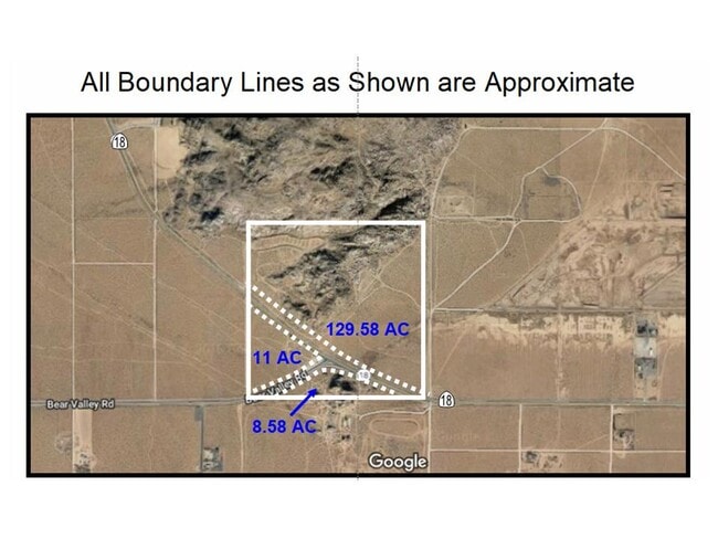
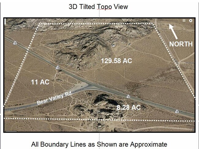
ALL THAT PTN SE 1/4 SEC 31 TP 5N R 2W LYING SWLY OF HGWY NO 18 AND NWLY OF CO ROAD 11 AC M/L
Wellsiteagricultural
San Bernardino
D
California
06071C6510H
11 AC
2024
Mojave River Valley
2025
Inland Empire (California)
009709
Riverside-San Bernardino-Ontario, CA
DEMOGRAPHICS near Highway 18
1 Mile
3 Mile
5 Mile
2024 Total Population
6,306
33,726
115,520
2029 Population
6,425
34,334
118,343
Pop Growth 2024-2029
+ 1.89%
+ 1.80%
+ 2.44%
Average Age
39
37
36
2024 Total Households
2,191
10,861
36,645
HH Growth 2024-2029
+ 1.83%
+ 1.82%
+ 2.51%
Median Household Inc
$88,381
$59,064
$66,624
Avg Household Size
2.90
3.00
3.10
2024 Avg HH Vehicles
2.00
2.00
2.00
Median Home Value
$447,146
$370,926
$339,712
Median Year Built
1988
1982
1987
Nearby Places
Map Layers
Map Styles
 Street
 Aerial
- Restaurants
- Banks
- Shops
- Fitness
- Groceries
SALE & LEASE HISTORY
LISTING DATE
SALE/LEASE

Sep 06, 2022
For Sale
Nearby Properties
Address
Land Use
TOTAL SIZE
Lot Size
Zoning
Address
Land Use
TOTAL SIZE
Lot Size
Zoning
4,998 SF
2.76 AC
Address
Land Use
TOTAL SIZE
Lot Size
Zoning
37,521 SF
24.52 AC
Address
Land Use
TOTAL SIZE
Lot Size
Zoning
12,505 SF
4.84 AC
Address
Land Use
TOTAL SIZE
Lot Size
Zoning
19,590 SF
2.19 AC
Address
Land Use
TOTAL SIZE
Lot Size
Zoning
19,140 SF
1.84 AC
Address
Land Use
TOTAL SIZE
Lot Size
Zoning
80,103 SF
12.65 AC
Address
Land Use
TOTAL SIZE
Lot Size
Zoning
14,570 SF
2.30 AC
Address
Land Use
TOTAL SIZE
Lot Size
Zoning
1.48 AC
Address
Land Use
TOTAL SIZE
Lot Size
Zoning
50,782 SF
11.04 AC
Address
Land Use
TOTAL SIZE
Lot Size
Zoning
120 AC
RL
Address
Land Use
TOTAL SIZE
Lot Size
Zoning
35,360 SF
0.81 AC
Address
Land Use
TOTAL SIZE
Lot Size
Zoning
Address
Land Use
TOTAL SIZE
Lot Size
Zoning
160 AC
RL
Address
Land Use
TOTAL SIZE
Lot Size
Zoning
625 SF
18.34 AC
Address
Land Use
TOTAL SIZE
Lot Size
Zoning
4,194 SF
0.42 AC
Address
Land Use
TOTAL SIZE
Lot Size
Zoning
38.79 AC
CG
Address
Land Use
TOTAL SIZE
Lot Size
Zoning
13,900 SF
4.09 AC
IC
Address
Land Use
TOTAL SIZE
Lot Size
Zoning
146.89 AC
RL10
Address
Land Use
TOTAL SIZE
Lot Size
Zoning
18.99 AC
Address
Land Use
TOTAL SIZE
Lot Size
Zoning
8.77 AC
Address
Land Use
TOTAL SIZE
Lot Size
Zoning
6,440 SF
0.63 AC
Address
Land Use
TOTAL SIZE
Lot Size
Zoning
1,964 SF
17.60 AC
Address
Land Use
TOTAL SIZE
Lot Size
Zoning
3,750 SF
0.22 AC
Address
Land Use
TOTAL SIZE
Lot Size
Zoning
3,512 SF
0.53 AC
Address
Land Use
TOTAL SIZE
Lot Size
Zoning
160 AC
RL10
Address
Land Use
TOTAL SIZE
Lot Size
Zoning
3,500 SF
0.51 AC
Address
Land Use
TOTAL SIZE
Lot Size
Zoning
3,472 SF
0.55 AC
Address
Land Use
TOTAL SIZE
Lot Size
Zoning
4.49 AC
The World's #1 Commercial Real Estate Marketplace
Connect with us
© 2025 CoStar Group
The information above has been obtained from sources believed reliable. While we do not doubt its accuracy we have not verified it and make no guarantee, warranty or representation about it. It is your responsibility to independently confirm its accuracy and completeness. Any projections, opinions, assumptions, or estimates used are for example only and do not represent the current or future performance of the property. The value of this transaction to you depends on tax and other factors which should be evaluated by your tax, financial, and legal advisors. You and your advisors should conduct a careful, independent investigation of the property to determine to your satisfaction the suitability of the property for your needs.