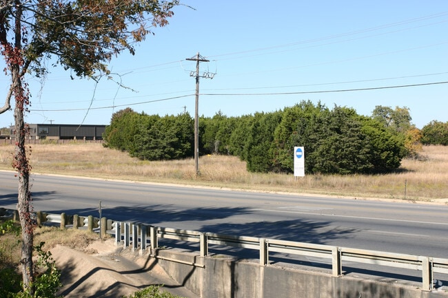
Property Record
Highway 183, Liberty Hill, TX 78642
Property Detail
Highway 183
Austin-Round Rock-San Marcos, TX
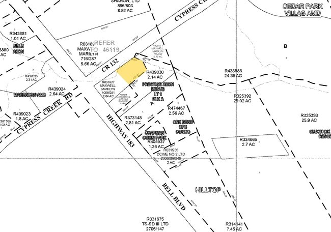
AW0338 AW0338 - I. & G.N.R.R. CO. SUR., ACRES 1.63, AKA PR 905PT
R021920
WILLIAMSON
Vacantlandnec
Texas
B and X Area of moderate flood hazard, usually the area between the limits of the 100-year and 500-year floods.
4.88 AC
2024
Cedar Park
2025
Austin
020207
NEARBY LISTINGS FOR SALE OR LEASE
-
-
View all Liberty Hill listings for sale on LoopNet.com
DEMOGRAPHICS near Highway 183
1 mile
3 mile
5 mile
2025 Total Population
10,608
99,875
240,074
2030 Population
11,863
112,412
269,025
Pop Growth 2025-2030
+ 11.83%
+ 12.55%
+ 12.06%
Average Age
37
37
37
2025 Total Households
4,118
39,000
90,337
HH Growth 2025-2030
+ 12.24%
+ 13.25%
+ 12.71%
Median Household Inc
$106,528
$113,902
$123,652
Avg Household Size
2.50
2.50
2.60
2025 Avg HH Vehicles
2.00
2.00
2.00
Median Home Value
$492,288
$493,976
$553,797
Median Year Built
1999
2004
2003
Nearby Places
Map Layers
Map Styles
 Street
 Aerial
Transit
 Traffic
 Biking
Places
Listings with unknown addresses are not visible on the map
- Restaurants
- Banks
- Shops
- Fitness
- Groceries
PUBLIC TRANSPORTATION
AIRPORT
Robert Gray AAF
Drive
Walk
Distance
Robert Gray AAF
47 min
27.9 mi
Killeen Municipal
Drive
Walk
Distance
Killeen Municipal
46 min
33.9 mi
Freight Ports
Calhoun Port
Drive
Walk
Distance
Calhoun Port
229 min
192.5 mi
Nearby Properties
Address
Land Use
TOTAL SIZE
Lot Size
Zoning
Address
Land Use
TOTAL SIZE
Lot Size
Zoning
129.94 AC
Address
Land Use
TOTAL SIZE
Lot Size
Zoning
21,640 SF
5 AC
Address
Land Use
TOTAL SIZE
Lot Size
Zoning
11,886 SF
19.11 AC
Address
Land Use
TOTAL SIZE
Lot Size
Zoning
2,331 SF
4.17 AC
Address
Land Use
TOTAL SIZE
Lot Size
Zoning
19,401 SF
20.32 AC
Address
Land Use
TOTAL SIZE
Lot Size
Zoning
12.89 AC
Address
Land Use
TOTAL SIZE
Lot Size
Zoning
12.89 AC
Address
Land Use
TOTAL SIZE
Lot Size
Zoning
Address
Land Use
TOTAL SIZE
Lot Size
Zoning
61.88 AC
Address
Land Use
TOTAL SIZE
Lot Size
Zoning
9,545 SF
3.21 AC
Address
Land Use
TOTAL SIZE
Lot Size
Zoning
7,500 SF
9.16 AC
Address
Land Use
TOTAL SIZE
Lot Size
Zoning
12,220 SF
7.03 AC
Address
Land Use
TOTAL SIZE
Lot Size
Zoning
10,832 SF
4.69 AC
Address
Land Use
TOTAL SIZE
Lot Size
Zoning
5,440 SF
18.18 AC
Address
Land Use
TOTAL SIZE
Lot Size
Zoning
784 SF
22.54 AC
Address
Land Use
TOTAL SIZE
Lot Size
Zoning
192 SF
12.96 AC
Address
Land Use
TOTAL SIZE
Lot Size
Zoning
10.02 AC
Address
Land Use
TOTAL SIZE
Lot Size
Zoning
5,046 SF
12.06 AC
Address
Land Use
TOTAL SIZE
Lot Size
Zoning
4,818 SF
7.07 AC
Address
Land Use
TOTAL SIZE
Lot Size
Zoning
4,668 SF
4.77 AC
Address
Land Use
TOTAL SIZE
Lot Size
Zoning
864 SF
100 AC
Address
Land Use
TOTAL SIZE
Lot Size
Zoning
5,165 SF
0.56 AC
Address
Land Use
TOTAL SIZE
Lot Size
Zoning
4,833 SF
22.81 AC
Address
Land Use
TOTAL SIZE
Lot Size
Zoning
5,514 SF
10.01 AC
Address
Land Use
TOTAL SIZE
Lot Size
Zoning
2,850 SF
10 AC
Address
Land Use
TOTAL SIZE
Lot Size
Zoning
3,138 SF
23.19 AC
Address
Land Use
TOTAL SIZE
Lot Size
Zoning
4,468 SF
1.19 AC
Address
Land Use
TOTAL SIZE
Lot Size
Zoning
4,591 SF
12.60 AC
Address
Land Use
TOTAL SIZE
Lot Size
Zoning
4,694 SF
1.02 AC
Address
Land Use
TOTAL SIZE
Lot Size
Zoning
4,750 SF
2 AC
The World's #1 Commercial Real Estate Marketplace
Connect with us
© 2026 CoStar Group
The information above has been obtained from sources believed reliable. While we do not doubt its accuracy we have not verified it and make no guarantee, warranty or representation about it. It is your responsibility to independently confirm its accuracy and completeness. Any projections, opinions, assumptions, or estimates used are for example only and do not represent the current or future performance of the property. The value of this transaction to you depends on tax and other factors which should be evaluated by your tax, financial, and legal advisors. You and your advisors should conduct a careful, independent investigation of the property to determine to your satisfaction the suitability of the property for your needs.