Property Record
Highway 185, Seadrift, TX 77983
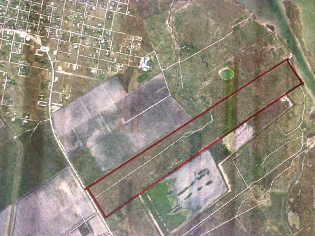

Property Detail
Highway 185
Port Lavaca, TX
A0013 JOSE FELIX DE LA FUENTES, TRACT 3 BINDEWALD EST PRTN, ACRES 200.62
30149
CALHOUN
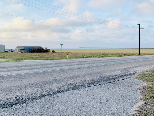
Agriculturalland
Texas
VE and V1-30 Coastal areas with a 1% or greater chance of flooding and an additional hazard associated with storm waves. These areas have a 26% chance of flooding over the life of a 30-year mortgage.
200.62 AC
2025
Texas South Area
2025
Other Market Areas
000502
NEARBY LISTINGS FOR SALE OR LEASE
-
-
View all Seadrift listings for sale on LoopNet.com
DEMOGRAPHICS near Highway 185
1 mile
3 mile
5 mile
2025 Total Population
75
794
945
2030 Population
69
719
859
Pop Growth 2025-2030
(8.00%)
(9.45%)
(9.10%)
Average Age
45
45
45
2025 Total Households
30
312
376
HH Growth 2025-2030
(6.67%)
(9.62%)
(8.78%)
Median Household Inc
$97,499
$95,731
$95,990
Avg Household Size
2.40
2.50
2.50
2025 Avg HH Vehicles
2.00
2.00
2.00
Median Home Value
$168,181
$163,178
$171,830
Median Year Built
1997
1990
1994
Nearby Places
Map Layers
Map Styles
 Street
 Aerial
Transit
 Traffic
 Biking
Places
Listings with unknown addresses are not visible on the map
- Restaurants
- Banks
- Shops
- Fitness
- Groceries
SALE & LEASE HISTORY
LISTING DATE
SALE/LEASE

Sep 24, 2016
For Sale
Mar 12, 2021
For Sale
Nearby Properties
Address
Land Use
TOTAL SIZE
Lot Size
Zoning
Address
Land Use
TOTAL SIZE
Lot Size
Zoning
144 SF
10.96 AC
Address
Land Use
TOTAL SIZE
Lot Size
Zoning
56,320 SF
30 AC
Address
Land Use
TOTAL SIZE
Lot Size
Zoning
12,112 SF
29.54 AC
Address
Land Use
TOTAL SIZE
Lot Size
Zoning
9,434 SF
42 AC
Address
Land Use
TOTAL SIZE
Lot Size
Zoning
10,200 SF
1.98 AC
Address
Land Use
TOTAL SIZE
Lot Size
Zoning
6,100 SF
1.13 AC
Address
Land Use
TOTAL SIZE
Lot Size
Zoning
9,100 SF
0.98 AC
Address
Land Use
TOTAL SIZE
Lot Size
Zoning
7,164 SF
0.98 AC
Address
Land Use
TOTAL SIZE
Lot Size
Zoning
8,320 SF
0.90 AC
Address
Land Use
TOTAL SIZE
Lot Size
Zoning
151 SF
221.81 AC
Address
Land Use
TOTAL SIZE
Lot Size
Zoning
18,302 SF
7.48 AC
Address
Land Use
TOTAL SIZE
Lot Size
Zoning
263.19 AC
Address
Land Use
TOTAL SIZE
Lot Size
Zoning
7,434 SF
0.44 AC
Address
Land Use
TOTAL SIZE
Lot Size
Zoning
7,200 SF
0.33 AC
Address
Land Use
TOTAL SIZE
Lot Size
Zoning
6,700 SF
0.31 AC
Address
Land Use
TOTAL SIZE
Lot Size
Zoning
2,400 SF
130.03 AC
Address
Land Use
TOTAL SIZE
Lot Size
Zoning
1,460 SF
182.41 AC
Address
Land Use
TOTAL SIZE
Lot Size
Zoning
165.73 AC
Address
Land Use
TOTAL SIZE
Lot Size
Zoning
209.14 AC
Address
Land Use
TOTAL SIZE
Lot Size
Zoning
2,639 SF
1.76 AC
Address
Land Use
TOTAL SIZE
Lot Size
Zoning
1,878 SF
1.75 AC
Address
Land Use
TOTAL SIZE
Lot Size
Zoning
199.40 AC
Address
Land Use
TOTAL SIZE
Lot Size
Zoning
194.58 AC
Address
Land Use
TOTAL SIZE
Lot Size
Zoning
8,128 SF
0.98 AC
Address
Land Use
TOTAL SIZE
Lot Size
Zoning
3,680 SF
0.80 AC
Address
Land Use
TOTAL SIZE
Lot Size
Zoning
2,806 SF
4.10 AC
Address
Land Use
TOTAL SIZE
Lot Size
Zoning
4,000 SF
161.60 AC
Address
Land Use
TOTAL SIZE
Lot Size
Zoning
25,944 SF
1.96 AC
The World's #1 Commercial Real Estate Marketplace
Connect with us
© 2026 CoStar Group
The information above has been obtained from sources believed reliable. While we do not doubt its accuracy we have not verified it and make no guarantee, warranty or representation about it. It is your responsibility to independently confirm its accuracy and completeness. Any projections, opinions, assumptions, or estimates used are for example only and do not represent the current or future performance of the property. The value of this transaction to you depends on tax and other factors which should be evaluated by your tax, financial, and legal advisors. You and your advisors should conduct a careful, independent investigation of the property to determine to your satisfaction the suitability of the property for your needs.