Property Record
3115 Whitehall Rd, Anderson, SC 29626
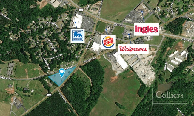

Property Detail
3115 Whitehall Rd
Greenville-Anderson-Greer, SC
CP 076/794 F000 D000 HWY 187 3.11 AC
069-00-01-002
ANDERSON
Agriculturalland
South Carolina
B and X Area of moderate flood hazard, usually the area between the limits of the 100-year and 500-year floods.
3.10 AC
2025
Anderson County
2025
Greenville/Spartanburg
011001
NEARBY LISTINGS FOR SALE OR LEASE
DEMOGRAPHICS near 3115 Whitehall Rd
1 mile
3 mile
5 mile
2025 Total Population
1,928
10,809
29,055
2030 Population
2,030
11,355
30,659
Pop Growth 2025-2030
+ 5.29%
+ 5.05%
+ 5.52%
Average Age
42
43
43
2025 Total Households
769
4,387
12,038
HH Growth 2025-2030
+ 5.59%
+ 5.36%
+ 5.77%
Median Household Inc
$68,989
$73,121
$66,669
Avg Household Size
2.50
2.40
2.40
2025 Avg HH Vehicles
2.00
2.00
2.00
Median Home Value
$254,999
$260,225
$250,638
Median Year Built
1994
1992
1991
Nearby Places
Map Layers
Map Styles
 Street
 Aerial
Transit
 Traffic
 Biking
Places
Listings with unknown addresses are not visible on the map
- Restaurants
- Banks
- Shops
- Fitness
- Groceries
SALE & LEASE HISTORY
LISTING DATE
SALE/LEASE

Dec 21, 2018
For Sale
Aug 20, 2021
For Sale
Nearby Properties
Address
Land Use
TOTAL SIZE
Lot Size
Zoning
Address
Land Use
TOTAL SIZE
Lot Size
Zoning
58,862 SF
6.89 AC
Address
Land Use
TOTAL SIZE
Lot Size
Zoning
62,610 SF
10.50 AC
Address
Land Use
TOTAL SIZE
Lot Size
Zoning
13,590 SF
1.88 AC
Address
Land Use
TOTAL SIZE
Lot Size
Zoning
5,988 SF
21.99 AC
Address
Land Use
TOTAL SIZE
Lot Size
Zoning
43,241 SF
7.21 AC
Address
Land Use
TOTAL SIZE
Lot Size
Zoning
10.75 AC
Address
Land Use
TOTAL SIZE
Lot Size
Zoning
0.83 AC
Address
Land Use
TOTAL SIZE
Lot Size
Zoning
360 SF
9.68 AC
Address
Land Use
TOTAL SIZE
Lot Size
Zoning
50,724 SF
17.79 AC
Address
Land Use
TOTAL SIZE
Lot Size
Zoning
2,366 SF
1.09 AC
Address
Land Use
TOTAL SIZE
Lot Size
Zoning
1.25 AC
Address
Land Use
TOTAL SIZE
Lot Size
Zoning
4,000 SF
2.02 AC
Address
Land Use
TOTAL SIZE
Lot Size
Zoning
5,965 SF
1.13 AC
Address
Land Use
TOTAL SIZE
Lot Size
Zoning
1.22 AC
Address
Land Use
TOTAL SIZE
Lot Size
Zoning
1,155 SF
2.81 AC
Address
Land Use
TOTAL SIZE
Lot Size
Zoning
19,780 SF
2.88 AC
Address
Land Use
TOTAL SIZE
Lot Size
Zoning
17,174 SF
1.64 AC
Address
Land Use
TOTAL SIZE
Lot Size
Zoning
7,500 SF
4.10 AC
Address
Land Use
TOTAL SIZE
Lot Size
Zoning
4,574 SF
6.39 AC
Address
Land Use
TOTAL SIZE
Lot Size
Zoning
14.19 AC
Address
Land Use
TOTAL SIZE
Lot Size
Zoning
1,233 SF
1.65 AC
Address
Land Use
TOTAL SIZE
Lot Size
Zoning
9,058 SF
2.30 AC
Address
Land Use
TOTAL SIZE
Lot Size
Zoning
8,474 SF
1.57 AC
Address
Land Use
TOTAL SIZE
Lot Size
Zoning
10,400 SF
19.19 AC
Address
Land Use
TOTAL SIZE
Lot Size
Zoning
9,145 SF
0.68 AC
Address
Land Use
TOTAL SIZE
Lot Size
Zoning
3,426 SF
1.50 AC
Address
Land Use
TOTAL SIZE
Lot Size
Zoning
3,463 SF
1.16 AC
Address
Land Use
TOTAL SIZE
Lot Size
Zoning
24.25 AC
Address
Land Use
TOTAL SIZE
Lot Size
Zoning
12,185 SF
3 AC
Address
Land Use
TOTAL SIZE
Lot Size
Zoning
25,000 SF
50 AC
The World's #1 Commercial Real Estate Marketplace
Connect with us
© 2026 CoStar Group
The information above has been obtained from sources believed reliable. While we do not doubt its accuracy we have not verified it and make no guarantee, warranty or representation about it. It is your responsibility to independently confirm its accuracy and completeness. Any projections, opinions, assumptions, or estimates used are for example only and do not represent the current or future performance of the property. The value of this transaction to you depends on tax and other factors which should be evaluated by your tax, financial, and legal advisors. You and your advisors should conduct a careful, independent investigation of the property to determine to your satisfaction the suitability of the property for your needs.