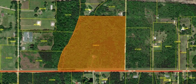
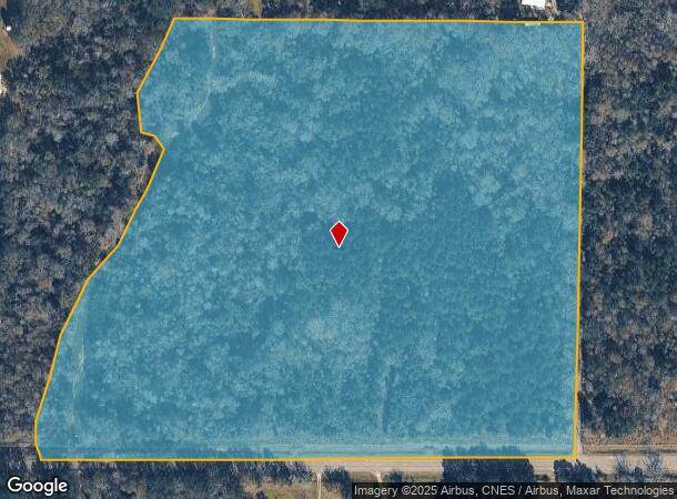
Property Record
Highway 190 E, , LA
NEARBY LISTINGS FOR SALE OR LEASE
-
-
View all listings for sale on LoopNet.com
Property Detail
Highway 190 E
Hammond, LA
Riverdale Heights
02348918
39.19 LOT 16 RIVERDALE HEIGHTS OF SEC 21 T6SR9E B169 P446 B177 P603 LESS 0.808A HWY B604 P551 B1489 P728
Sfr
Tangipahoa
AE
Louisiana
22105C0370F
16
2024
39.19 AC
2024
Louisiana South Area
953700
Other Market Areas
1,800 SF
DEMOGRAPHICS near Highway 190 E
1 mile
3 mile
5 mile
2024 Total Population
403
3,400
12,290
2029 Population
449
3,802
13,596
Pop Growth 2024-2029
+ 11.41%
+ 11.82%
+ 10.63%
Average Age
38
38
37
2024 Total Households
149
1,255
4,529
HH Growth 2024-2029
+ 11.41%
+ 11.79%
+ 10.64%
Median Household Inc
$70,178
$62,437
$68,189
Avg Household Size
2.60
2.60
2.60
2024 Avg HH Vehicles
2.00
2.00
2.00
Median Home Value
$190,243
$184,532
$208,341
Median Year Built
2010
2010
2009
Nearby Places
Map Layers
Map Styles
 Street
 Aerial
Transit
 Traffic
 Biking
Places
Listings with unknown addresses are not visible on the map
- Restaurants
- Banks
- Shops
- Fitness
- Groceries
PUBLIC TRANSPORTATION
COMMUTER RAIL
Hammond Amtrak Station (City of New Orleans - Amtrak)
Drive
Walk
Distance
Hammond Amtrak Station (City of New Orleans - Amtrak)
14 min
9.7 mi
Freight Ports
Port of New Orleans
Drive
Walk
Distance
Port of New Orleans
76 min
54.5 mi
SALE & LEASE HISTORY
LISTING DATE
SALE/LEASE

Nov 19, 2021
For Sale
Nearby Properties
Address
Land Use
TOTAL SIZE
Lot Size
Zoning
Address
Land Use
TOTAL SIZE
Lot Size
Zoning
875,000 SF
117.84 AC
Address
Land Use
TOTAL SIZE
Lot Size
Zoning
124,000 SF
23.77 AC
Address
Land Use
TOTAL SIZE
Lot Size
Zoning
42,000 SF
7.46 AC
Address
Land Use
TOTAL SIZE
Lot Size
Zoning
14.03 AC
Address
Land Use
TOTAL SIZE
Lot Size
Zoning
6,043 SF
1.74 AC
Address
Land Use
TOTAL SIZE
Lot Size
Zoning
7,700 SF
3.51 AC
Address
Land Use
TOTAL SIZE
Lot Size
Zoning
6,680 SF
55.61 AC
Address
Land Use
TOTAL SIZE
Lot Size
Zoning
5,251 SF
28.06 AC
Address
Land Use
TOTAL SIZE
Lot Size
Zoning
7,150 SF
10.02 AC
Address
Land Use
TOTAL SIZE
Lot Size
Zoning
10,640 SF
1.38 AC
Address
Land Use
TOTAL SIZE
Lot Size
Zoning
17,260 SF
3 AC
Address
Land Use
TOTAL SIZE
Lot Size
Zoning
Address
Land Use
TOTAL SIZE
Lot Size
Zoning
4,689 SF
1.50 AC
Address
Land Use
TOTAL SIZE
Lot Size
Zoning
11,592 SF
24.66 AC
Address
Land Use
TOTAL SIZE
Lot Size
Zoning
5,623 SF
1.89 AC
Address
Land Use
TOTAL SIZE
Lot Size
Zoning
8,125 SF
0.81 AC
Address
Land Use
TOTAL SIZE
Lot Size
Zoning
4,800 SF
1.10 AC
Address
Land Use
TOTAL SIZE
Lot Size
Zoning
6,450 SF
2.73 AC
Address
Land Use
TOTAL SIZE
Lot Size
Zoning
3,784 SF
6.24 AC
Address
Land Use
TOTAL SIZE
Lot Size
Zoning
6,000 SF
0.93 AC
Address
Land Use
TOTAL SIZE
Lot Size
Zoning
7,870 SF
59.42 AC
Address
Land Use
TOTAL SIZE
Lot Size
Zoning
Address
Land Use
TOTAL SIZE
Lot Size
Zoning
3,681 SF
0.41 AC
Address
Land Use
TOTAL SIZE
Lot Size
Zoning
3,839 SF
0.43 AC
Address
Land Use
TOTAL SIZE
Lot Size
Zoning
3,600 SF
2.57 AC
Address
Land Use
TOTAL SIZE
Lot Size
Zoning
Address
Land Use
TOTAL SIZE
Lot Size
Zoning
Address
Land Use
TOTAL SIZE
Lot Size
Zoning
7,500 SF
4.12 AC
Address
Land Use
TOTAL SIZE
Lot Size
Zoning
Address
Land Use
TOTAL SIZE
Lot Size
Zoning
3,680 SF
0.35 AC
The World's #1 Commercial Real Estate Marketplace
Connect with us
© 2026 CoStar Group
The information above has been obtained from sources believed reliable. While we do not doubt its accuracy we have not verified it and make no guarantee, warranty or representation about it. It is your responsibility to independently confirm its accuracy and completeness. Any projections, opinions, assumptions, or estimates used are for example only and do not represent the current or future performance of the property. The value of this transaction to you depends on tax and other factors which should be evaluated by your tax, financial, and legal advisors. You and your advisors should conduct a careful, independent investigation of the property to determine to your satisfaction the suitability of the property for your needs.