Property Record
Highway 195, Georgetown, TX 78633

Property Detail
Highway 195
Austin-Round Rock-San Marcos, TX
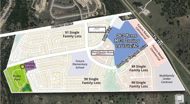
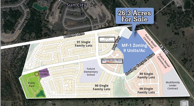
AW0216 AW0216 - EAVES, B. SUR., ACRES 35.071
R517969
WILLIAMSON
Vacantlandnec
Texas
B and X Area of moderate flood hazard, usually the area between the limits of the 100-year and 500-year floods.
35.07 AC
2024
Georgetown
2025
Austin
020119
NEARBY LISTINGS FOR SALE OR LEASE
DEMOGRAPHICS near Highway 195
1 mile
3 mile
5 mile
2025 Total Population
1,988
18,545
52,413
2030 Population
2,283
21,024
60,041
Pop Growth 2025-2030
+ 14.84%
+ 13.37%
+ 14.55%
Average Age
63
57
52
2025 Total Households
1,008
8,837
23,751
HH Growth 2025-2030
+ 14.78%
+ 13.69%
+ 14.90%
Median Household Inc
$103,660
$101,742
$98,887
Avg Household Size
2.00
2.10
2.20
2025 Avg HH Vehicles
2.00
2.00
2.00
Median Home Value
$502,123
$475,763
$476,384
Median Year Built
2010
2004
2006
Nearby Places
Map Layers
Map Styles
 Street
 Aerial
Transit
 Traffic
 Biking
Places
Listings with unknown addresses are not visible on the map
- Restaurants
- Banks
- Shops
- Fitness
- Groceries
PUBLIC TRANSPORTATION
AIRPORT
Killeen Municipal
Drive
Walk
Distance
Killeen Municipal
45 min
34.2 mi
Robert Gray AAF
Drive
Walk
Distance
Robert Gray AAF
49 min
35.0 mi
Freight Ports
Calhoun Port
Drive
Walk
Distance
Calhoun Port
217 min
190.8 mi
SALE & LEASE HISTORY
LISTING DATE
SALE/LEASE

Aug 31, 2021
For Sale
Nearby Properties
Address
Land Use
TOTAL SIZE
Lot Size
Zoning
Address
Land Use
TOTAL SIZE
Lot Size
Zoning
200,200 SF
34.02 AC
Address
Land Use
TOTAL SIZE
Lot Size
Zoning
495,945 SF
56.14 AC
Address
Land Use
TOTAL SIZE
Lot Size
Zoning
120,653 SF
12.83 AC
Address
Land Use
TOTAL SIZE
Lot Size
Zoning
192.21 AC
Address
Land Use
TOTAL SIZE
Lot Size
Zoning
219,839 SF
24.74 AC
Address
Land Use
TOTAL SIZE
Lot Size
Zoning
22,936 SF
111.18 AC
Address
Land Use
TOTAL SIZE
Lot Size
Zoning
14.60 AC
Address
Land Use
TOTAL SIZE
Lot Size
Zoning
Address
Land Use
TOTAL SIZE
Lot Size
Zoning
57,600 SF
4.12 AC
Address
Land Use
TOTAL SIZE
Lot Size
Zoning
30,112 SF
4.58 AC
Address
Land Use
TOTAL SIZE
Lot Size
Zoning
Address
Land Use
TOTAL SIZE
Lot Size
Zoning
57,600 SF
7.20 AC
Address
Land Use
TOTAL SIZE
Lot Size
Zoning
84,960 SF
5.12 AC
Address
Land Use
TOTAL SIZE
Lot Size
Zoning
26,306 SF
10.03 AC
Address
Land Use
TOTAL SIZE
Lot Size
Zoning
31,480 SF
19.73 AC
Address
Land Use
TOTAL SIZE
Lot Size
Zoning
43,000 SF
4.47 AC
Address
Land Use
TOTAL SIZE
Lot Size
Zoning
155,448 SF
281.82 AC
Address
Land Use
TOTAL SIZE
Lot Size
Zoning
31,314 SF
34.41 AC
Address
Land Use
TOTAL SIZE
Lot Size
Zoning
25,764 SF
5.34 AC
Address
Land Use
TOTAL SIZE
Lot Size
Zoning
11,200 SF
63.89 AC
Address
Land Use
TOTAL SIZE
Lot Size
Zoning
25.92 AC
Address
Land Use
TOTAL SIZE
Lot Size
Zoning
45,764 SF
11.23 AC
Address
Land Use
TOTAL SIZE
Lot Size
Zoning
1,453 SF
360.07 AC
Address
Land Use
TOTAL SIZE
Lot Size
Zoning
39,292 SF
200 AC
Address
Land Use
TOTAL SIZE
Lot Size
Zoning
35,534 SF
132.39 AC
1-RS
Address
Land Use
TOTAL SIZE
Lot Size
Zoning
56,950 SF
10 AC
Address
Land Use
TOTAL SIZE
Lot Size
Zoning
14,652 SF
18.54 AC
Address
Land Use
TOTAL SIZE
Lot Size
Zoning
35.03 AC
Address
Land Use
TOTAL SIZE
Lot Size
Zoning
32,935 SF
10 AC
Address
Land Use
TOTAL SIZE
Lot Size
Zoning
121.02 AC
The World's #1 Commercial Real Estate Marketplace
Connect with us
© 2026 CoStar Group
The information above has been obtained from sources believed reliable. While we do not doubt its accuracy we have not verified it and make no guarantee, warranty or representation about it. It is your responsibility to independently confirm its accuracy and completeness. Any projections, opinions, assumptions, or estimates used are for example only and do not represent the current or future performance of the property. The value of this transaction to you depends on tax and other factors which should be evaluated by your tax, financial, and legal advisors. You and your advisors should conduct a careful, independent investigation of the property to determine to your satisfaction the suitability of the property for your needs.