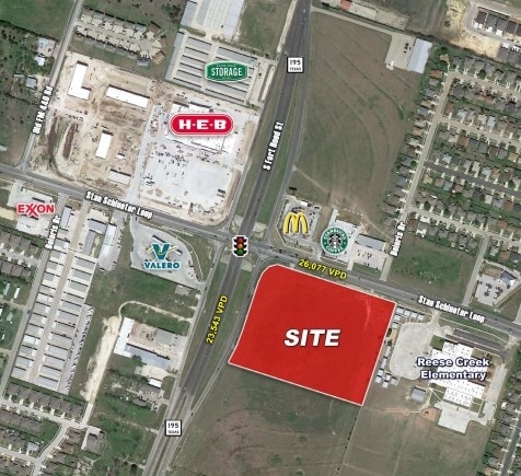
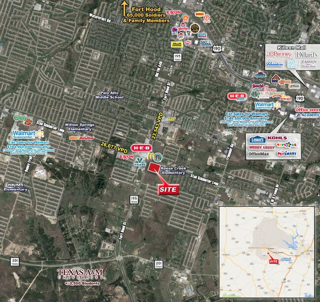
Property Record
2901 S Fort Hood St, Killeen, TX 76542


Current Lease Availabilities
Property Detail
2901 S Fort Hood St
Killeen-Temple, TX
A0857BC A WEBB, 20, ACRES 10.000
470388
BELL
Agriculturalland
Texas
B and X Area of moderate flood hazard, usually the area between the limits of the 100-year and 500-year floods.
10 AC
2025
Greater Killeen
2025
Killeen/Temple/Fort Hood
022504
NEARBY LISTINGS FOR SALE OR LEASE
DEMOGRAPHICS near 2901 S Fort Hood St
1 mile
3 mile
5 mile
2025 Total Population
11,072
90,172
169,898
2030 Population
11,766
95,302
179,605
Pop Growth 2025-2030
+ 6.27%
+ 5.69%
+ 5.71%
Average Age
32
33
32
2025 Total Households
3,770
32,594
59,112
HH Growth 2025-2030
+ 6.37%
+ 5.75%
+ 6.05%
Median Household Inc
$64,557
$62,136
$61,897
Avg Household Size
2.90
2.70
2.70
2025 Avg HH Vehicles
2.00
2.00
2.00
Median Home Value
$237,942
$220,815
$229,257
Median Year Built
2005
1998
1996
Nearby Places
Map Layers
Map Styles
 Street
 Aerial
Transit
 Traffic
 Biking
Places
Listings with unknown addresses are not visible on the map
- Restaurants
- Banks
- Shops
- Fitness
- Groceries
PUBLIC TRANSPORTATION
AIRPORT
Killeen Municipal
Drive
Walk
Distance
Killeen Municipal
11 min
5.4 mi
Robert Gray AAF
Drive
Walk
Distance
Robert Gray AAF
17 min
7.9 mi
Freight Ports
Port of Houston
Drive
Walk
Distance
Port of Houston
251 min
216.2 mi
Nearby Properties
Address
Land Use
TOTAL SIZE
Lot Size
Zoning
Address
Land Use
TOTAL SIZE
Lot Size
Zoning
1 SF
13.88 AC
Address
Land Use
TOTAL SIZE
Lot Size
Zoning
1 SF
27.58 AC
Address
Land Use
TOTAL SIZE
Lot Size
Zoning
2 SF
73.79 AC
Address
Land Use
TOTAL SIZE
Lot Size
Zoning
211,272 SF
18.64 AC
Address
Land Use
TOTAL SIZE
Lot Size
Zoning
234,548 SF
39.92 AC
Address
Land Use
TOTAL SIZE
Lot Size
Zoning
136,782 SF
6.64 AC
Address
Land Use
TOTAL SIZE
Lot Size
Zoning
1 SF
19.23 AC
Address
Land Use
TOTAL SIZE
Lot Size
Zoning
464,093 SF
71.50 AC
Address
Land Use
TOTAL SIZE
Lot Size
Zoning
133,210 SF
8.52 AC
R-3
Address
Land Use
TOTAL SIZE
Lot Size
Zoning
173,508 SF
8.90 AC
R-3
Address
Land Use
TOTAL SIZE
Lot Size
Zoning
160,143 SF
13.30 AC
Address
Land Use
TOTAL SIZE
Lot Size
Zoning
1 SF
40.54 AC
Address
Land Use
TOTAL SIZE
Lot Size
Zoning
187,440 SF
54.81 AC
Address
Land Use
TOTAL SIZE
Lot Size
Zoning
46,892 SF
2.48 AC
Address
Land Use
TOTAL SIZE
Lot Size
Zoning
154,910 SF
9.38 AC
Address
Land Use
TOTAL SIZE
Lot Size
Zoning
157,552 SF
9.61 AC
Address
Land Use
TOTAL SIZE
Lot Size
Zoning
1 SF
10.44 AC
Address
Land Use
TOTAL SIZE
Lot Size
Zoning
192,820 SF
14.26 AC
Address
Land Use
TOTAL SIZE
Lot Size
Zoning
386,344 SF
171.40 AC
B-5
Address
Land Use
TOTAL SIZE
Lot Size
Zoning
133,648 SF
6.52 AC
Address
Land Use
TOTAL SIZE
Lot Size
Zoning
108,964 SF
4.50 AC
Address
Land Use
TOTAL SIZE
Lot Size
Zoning
201,823 SF
20.78 AC
Address
Land Use
TOTAL SIZE
Lot Size
Zoning
228,165 SF
22.43 AC
Address
Land Use
TOTAL SIZE
Lot Size
Zoning
1 SF
31.31 AC
Address
Land Use
TOTAL SIZE
Lot Size
Zoning
176,443 SF
10 AC
R-3
Address
Land Use
TOTAL SIZE
Lot Size
Zoning
1 SF
27.42 AC
Address
Land Use
TOTAL SIZE
Lot Size
Zoning
126,152 SF
8 AC
B-5
Address
Land Use
TOTAL SIZE
Lot Size
Zoning
185,646 SF
10.65 AC
Address
Land Use
TOTAL SIZE
Lot Size
Zoning
50,493 SF
24.40 AC
Address
Land Use
TOTAL SIZE
Lot Size
Zoning
1 SF
18.98 AC
The World's #1 Commercial Real Estate Marketplace
Connect with us
© 2026 CoStar Group
The information above has been obtained from sources believed reliable. While we do not doubt its accuracy we have not verified it and make no guarantee, warranty or representation about it. It is your responsibility to independently confirm its accuracy and completeness. Any projections, opinions, assumptions, or estimates used are for example only and do not represent the current or future performance of the property. The value of this transaction to you depends on tax and other factors which should be evaluated by your tax, financial, and legal advisors. You and your advisors should conduct a careful, independent investigation of the property to determine to your satisfaction the suitability of the property for your needs.