Property Record
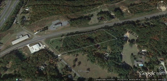
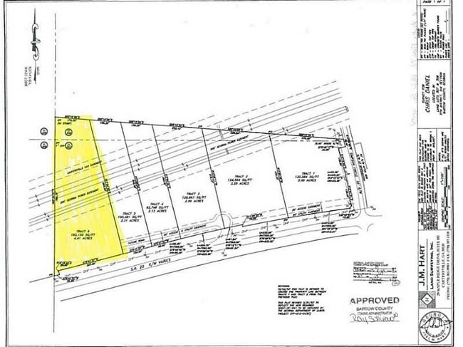
Highway 20, Cartersville, GA 30121

Property Detail
Highway 20
0091-0306-029
LL 306 LD 5
Commercialacreage
BARTOW
A1
Georgia
B and X Area of moderate flood hazard, usually the area between the limits of the 100-year and 500-year floods.
5.56 AC
2025
Bartow County
2025
Atlanta
960403
Atlanta-Sandy Springs-Roswell, GA
NEARBY LISTINGS FOR SALE OR LEASE
DEMOGRAPHICS near Highway 20
1 mile
3 mile
5 mile
2025 Total Population
2,602
27,279
51,396
2030 Population
2,854
29,201
54,945
Pop Growth 2025-2030
+ 9.68%
+ 7.05%
+ 6.91%
Average Age
41
39
40
2025 Total Households
943
10,580
19,516
HH Growth 2025-2030
+ 10.07%
+ 7.13%
+ 6.96%
Median Household Inc
$71,550
$76,569
$78,375
Avg Household Size
2.50
2.50
2.50
2025 Avg HH Vehicles
2.00
2.00
2.00
Median Home Value
$299,156
$284,520
$312,352
Median Year Built
2002
1993
1994
Nearby Places
Map Layers
Map Styles
 Street
 Aerial
Transit
 Traffic
 Biking
Places
Listings with unknown addresses are not visible on the map
- Restaurants
- Banks
- Shops
- Fitness
- Groceries
SALE & LEASE HISTORY
LISTING DATE
SALE/LEASE

Sep 24, 2016
For Sale
Nearby Properties
Address
Land Use
TOTAL SIZE
Lot Size
Zoning
Address
Land Use
TOTAL SIZE
Lot Size
Zoning
141,651 SF
181.89 AC
I1
Address
Land Use
TOTAL SIZE
Lot Size
Zoning
107,992 SF
46 AC
IN
Address
Land Use
TOTAL SIZE
Lot Size
Zoning
67,428 SF
36.96 AC
Address
Land Use
TOTAL SIZE
Lot Size
Zoning
7,488 SF
38.49 AC
IN
Address
Land Use
TOTAL SIZE
Lot Size
Zoning
90,497 SF
24.36 AC
Address
Land Use
TOTAL SIZE
Lot Size
Zoning
250,701 SF
15.17 AC
C1
Address
Land Use
TOTAL SIZE
Lot Size
Zoning
342,088 SF
49.67 AC
Address
Land Use
TOTAL SIZE
Lot Size
Zoning
33,096 SF
15.80 AC
Address
Land Use
TOTAL SIZE
Lot Size
Zoning
683.23 AC
Address
Land Use
TOTAL SIZE
Lot Size
Zoning
51,681 SF
16 AC
Address
Land Use
TOTAL SIZE
Lot Size
Zoning
122,352 SF
26.48 AC
IN
Address
Land Use
TOTAL SIZE
Lot Size
Zoning
615.33 AC
Address
Land Use
TOTAL SIZE
Lot Size
Zoning
151,571 SF
25.82 AC
Address
Land Use
TOTAL SIZE
Lot Size
Zoning
24,256 SF
11.87 AC
R3WC
Address
Land Use
TOTAL SIZE
Lot Size
Zoning
1,081.62 AC
Address
Land Use
TOTAL SIZE
Lot Size
Zoning
211,821 SF
20.32 AC
Address
Land Use
TOTAL SIZE
Lot Size
Zoning
8,064 SF
36.63 AC
IN
Address
Land Use
TOTAL SIZE
Lot Size
Zoning
60,361 SF
13.66 AC
A1
Address
Land Use
TOTAL SIZE
Lot Size
Zoning
20.79 AC
RESIDENTIA
Address
Land Use
TOTAL SIZE
Lot Size
Zoning
196,426 SF
37.60 AC
IN
Address
Land Use
TOTAL SIZE
Lot Size
Zoning
28,736 SF
8.53 AC
C1
Address
Land Use
TOTAL SIZE
Lot Size
Zoning
12,769 SF
4.44 AC
C1
Address
Land Use
TOTAL SIZE
Lot Size
Zoning
64,691 SF
6.95 AC
Address
Land Use
TOTAL SIZE
Lot Size
Zoning
59,880 SF
12.83 AC
C1
Address
Land Use
TOTAL SIZE
Lot Size
Zoning
43,842 SF
8.91 AC
A1
Address
Land Use
TOTAL SIZE
Lot Size
Zoning
103,600 SF
30.12 AC
Address
Land Use
TOTAL SIZE
Lot Size
Zoning
115,902 SF
10.88 AC
Address
Land Use
TOTAL SIZE
Lot Size
Zoning
32,952 SF
6.57 AC
Address
Land Use
TOTAL SIZE
Lot Size
Zoning
131,990 SF
18.59 AC
Address
Land Use
TOTAL SIZE
Lot Size
Zoning
73,808 SF
2.53 AC
The World's #1 Commercial Real Estate Marketplace
Connect with us
© 2026 CoStar Group
The information above has been obtained from sources believed reliable. While we do not doubt its accuracy we have not verified it and make no guarantee, warranty or representation about it. It is your responsibility to independently confirm its accuracy and completeness. Any projections, opinions, assumptions, or estimates used are for example only and do not represent the current or future performance of the property. The value of this transaction to you depends on tax and other factors which should be evaluated by your tax, financial, and legal advisors. You and your advisors should conduct a careful, independent investigation of the property to determine to your satisfaction the suitability of the property for your needs.