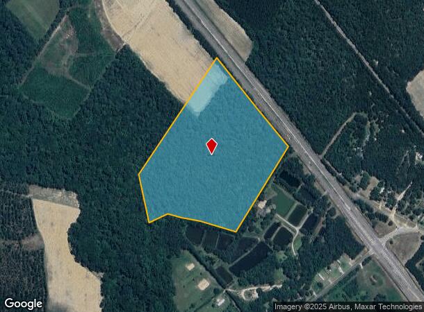
Property Record
N Highway 21, Springfield, GA 31329
NEARBY LISTINGS FOR SALE OR LEASE
Property Detail
N Highway 21
03660-00000-004-000
28.852 AC PAR 3 2025 CUVA
Privatepreserveopenspacevacantlandforestlandconservation
Effingham
AE
Georgia
13103C0164E
28.85 AC
2025
Effingham County
2025
Savannah
030206
Savannah, GA
DEMOGRAPHICS near N Highway 21
1 Mile
3 Mile
5 Mile
2024 Total Population
536
5,909
12,710
2029 Population
616
6,851
14,823
Pop Growth 2024-2029
+ 14.93%
+ 15.94%
+ 16.62%
Average Age
36
38
37
2024 Total Households
183
2,018
4,373
HH Growth 2024-2029
+ 14.75%
+ 15.96%
+ 16.60%
Median Household Inc
$51,739
$62,491
$66,776
Avg Household Size
2.90
2.80
2.80
2024 Avg HH Vehicles
2.00
2.00
2.00
Median Home Value
$210,526
$224,517
$219,754
Median Year Built
1999
1995
2000
Nearby Places
Map Layers
Map Styles
 Street
 Aerial
- Restaurants
- Banks
- Shops
- Fitness
- Groceries
PUBLIC TRANSPORTATION
AIRPORT
Savannah/Hilton Head International
DRIVE
WALK
Distance
Savannah/Hilton Head International
35 min
25.3 mi
Freight Ports
Georgia Ports - Savannah
DRIVE
WALK
Distance
Georgia Ports - Savannah
31 min
23.7 mi
SALE & LEASE HISTORY
LISTING DATE
SALE/LEASE

Mar 30, 2021
For Sale
Nearby Properties
Address
Land Use
TOTAL SIZE
Lot Size
Zoning
Address
Land Use
TOTAL SIZE
Lot Size
Zoning
6,914 SF
11.15 AC
B-1
Address
Land Use
TOTAL SIZE
Lot Size
Zoning
52,779 SF
0.82 AC
B-2
Address
Land Use
TOTAL SIZE
Lot Size
Zoning
10,118 SF
16.75 AC
R-3
Address
Land Use
TOTAL SIZE
Lot Size
Zoning
42,403 SF
30 AC
AR-1
Address
Land Use
TOTAL SIZE
Lot Size
Zoning
21,445 SF
1.60 AC
B-2
Address
Land Use
TOTAL SIZE
Lot Size
Zoning
14,472 SF
2.27 AC
B-1
Address
Land Use
TOTAL SIZE
Lot Size
Zoning
30,000 SF
18.19 AC
I-1
Address
Land Use
TOTAL SIZE
Lot Size
Zoning
5,066 SF
2.67 AC
B-1
Address
Land Use
TOTAL SIZE
Lot Size
Zoning
137.58 AC
R-6
Address
Land Use
TOTAL SIZE
Lot Size
Zoning
10,857 SF
1.45 AC
B-1
Address
Land Use
TOTAL SIZE
Lot Size
Zoning
13,902 SF
3.85 AC
I-1
Address
Land Use
TOTAL SIZE
Lot Size
Zoning
20,776 SF
0.92 AC
R-1
Address
Land Use
TOTAL SIZE
Lot Size
Zoning
11,036 SF
6.15 AC
R-1
Address
Land Use
TOTAL SIZE
Lot Size
Zoning
17,855 SF
1.16 AC
B-2
Address
Land Use
TOTAL SIZE
Lot Size
Zoning
14.57 AC
B-1
Address
Land Use
TOTAL SIZE
Lot Size
Zoning
13,036 SF
3.33 AC
B-1
Address
Land Use
TOTAL SIZE
Lot Size
Zoning
5,949 SF
3.26 AC
AR-1
Address
Land Use
TOTAL SIZE
Lot Size
Zoning
10,000 SF
0.57 AC
B-2
Address
Land Use
TOTAL SIZE
Lot Size
Zoning
10,155 SF
1.39 AC
B-1
Address
Land Use
TOTAL SIZE
Lot Size
Zoning
22,516 SF
0.61 AC
B-2
Address
Land Use
TOTAL SIZE
Lot Size
Zoning
1,108.52 AC
AR-1
Address
Land Use
TOTAL SIZE
Lot Size
Zoning
6,916 SF
0.92 AC
B-2
Address
Land Use
TOTAL SIZE
Lot Size
Zoning
2,108 SF
2.29 AC
B-1
Address
Land Use
TOTAL SIZE
Lot Size
Zoning
5,040 SF
9.06 AC
AR-1
Address
Land Use
TOTAL SIZE
Lot Size
Zoning
7,800 SF
2.84 AC
B-2
Address
Land Use
TOTAL SIZE
Lot Size
Zoning
1,886 SF
6 AC
B-2
Address
Land Use
TOTAL SIZE
Lot Size
Zoning
5.60 AC
AR-1
Address
Land Use
TOTAL SIZE
Lot Size
Zoning
4,696 SF
0.79 AC
B-1
Address
Land Use
TOTAL SIZE
Lot Size
Zoning
7,920 SF
0.23 AC
B-2
Address
Land Use
TOTAL SIZE
Lot Size
Zoning
9,754 SF
0.41 AC
B-2
The World's #1 Commercial Real Estate Marketplace
Connect with us
© 2025 CoStar Group
The information above has been obtained from sources believed reliable. While we do not doubt its accuracy we have not verified it and make no guarantee, warranty or representation about it. It is your responsibility to independently confirm its accuracy and completeness. Any projections, opinions, assumptions, or estimates used are for example only and do not represent the current or future performance of the property. The value of this transaction to you depends on tax and other factors which should be evaluated by your tax, financial, and legal advisors. You and your advisors should conduct a careful, independent investigation of the property to determine to your satisfaction the suitability of the property for your needs.