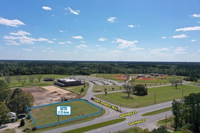
Property Record
Highway 21, Springfield, GA 31329


Property Detail
Highway 21
Savannah, GA
1.33 AC LOT A (OUT S131-9) PLT 28/912 LANDDIST: 11
S1310009A00
EFFINGHAM
Commercialacreage
Georgia
B-1
a
B and X Area of moderate flood hazard, usually the area between the limits of the 100-year and 500-year floods.
1.33 AC
2025
Effingham County
2025
Savannah
030206
NEARBY LISTINGS FOR SALE OR LEASE
DEMOGRAPHICS near Highway 21
1 mile
3 mile
5 mile
2025 Total Population
630
8,648
20,963
2030 Population
704
9,662
23,426
Pop Growth 2025-2030
+ 11.75%
+ 11.73%
+ 11.75%
Average Age
35
37
37
2025 Total Households
217
2,989
7,284
HH Growth 2025-2030
+ 11.52%
+ 11.88%
+ 11.86%
Median Household Inc
$86,440
$80,467
$82,778
Avg Household Size
2.90
2.80
2.80
2025 Avg HH Vehicles
2.00
2.00
2.00
Median Home Value
$291,227
$274,489
$274,778
Median Year Built
2006
2002
2002
Nearby Places
Map Layers
Map Styles
 Street
 Aerial
Layers
 Traffic
 Biking
Places
Listings with unknown addresses are not visible on the map
- Restaurants
- Banks
- Shops
- Fitness
- Groceries
PUBLIC TRANSPORTATION
AIRPORT
Savannah/Hilton Head International
Drive
Walk
Distance
Savannah/Hilton Head International
31 min
21.1 mi
SALE & LEASE HISTORY
LISTING DATE
SALE/LEASE

Apr 20, 2022
For Sale
Nearby Properties
Address
Land Use
TOTAL SIZE
Lot Size
Zoning
Address
Land Use
TOTAL SIZE
Lot Size
Zoning
258,754 SF
43.46 AC
I-1
Address
Land Use
TOTAL SIZE
Lot Size
Zoning
6,914 SF
11.15 AC
B-1
Address
Land Use
TOTAL SIZE
Lot Size
Zoning
52,779 SF
0.82 AC
B-2
Address
Land Use
TOTAL SIZE
Lot Size
Zoning
241,200 SF
30.97 AC
I-1
Address
Land Use
TOTAL SIZE
Lot Size
Zoning
61,475 SF
60.87 AC
I-1
Address
Land Use
TOTAL SIZE
Lot Size
Zoning
162,400 SF
8.41 AC
I-1
Address
Land Use
TOTAL SIZE
Lot Size
Zoning
10,118 SF
16.75 AC
R-3
Address
Land Use
TOTAL SIZE
Lot Size
Zoning
6,720 SF
87.16 AC
I-1
Address
Land Use
TOTAL SIZE
Lot Size
Zoning
21,445 SF
1.60 AC
B-2
Address
Land Use
TOTAL SIZE
Lot Size
Zoning
10,200 SF
6.92 AC
B-1
Address
Land Use
TOTAL SIZE
Lot Size
Zoning
15,088 SF
11.31 AC
B-3
Address
Land Use
TOTAL SIZE
Lot Size
Zoning
102,010 SF
5.94 AC
I-1
Address
Land Use
TOTAL SIZE
Lot Size
Zoning
97,800 SF
6.72 AC
I-1
Address
Land Use
TOTAL SIZE
Lot Size
Zoning
38.23 AC
PD
Address
Land Use
TOTAL SIZE
Lot Size
Zoning
14,472 SF
2.27 AC
B-1
Address
Land Use
TOTAL SIZE
Lot Size
Zoning
30,400 SF
3.17 AC
I-1
Address
Land Use
TOTAL SIZE
Lot Size
Zoning
5,400 SF
11.29 AC
I-1
Address
Land Use
TOTAL SIZE
Lot Size
Zoning
25,920 SF
77.47 AC
I-1
Address
Land Use
TOTAL SIZE
Lot Size
Zoning
55,200 SF
9.04 AC
I-1
Address
Land Use
TOTAL SIZE
Lot Size
Zoning
64.76 AC
L-1
Address
Land Use
TOTAL SIZE
Lot Size
Zoning
51,356 SF
4.73 AC
I-1
Address
Land Use
TOTAL SIZE
Lot Size
Zoning
27,762 SF
1.45 AC
R-1
Address
Land Use
TOTAL SIZE
Lot Size
Zoning
10,872 SF
5 AC
I-1
Address
Land Use
TOTAL SIZE
Lot Size
Zoning
53,184 SF
5 AC
I-1
Address
Land Use
TOTAL SIZE
Lot Size
Zoning
45,627 SF
5 AC
I-1
Address
Land Use
TOTAL SIZE
Lot Size
Zoning
5,066 SF
2.67 AC
B-1
Address
Land Use
TOTAL SIZE
Lot Size
Zoning
10,857 SF
1.45 AC
B-1
Address
Land Use
TOTAL SIZE
Lot Size
Zoning
20,776 SF
0.92 AC
R-1
Address
Land Use
TOTAL SIZE
Lot Size
Zoning
11,036 SF
6.15 AC
R-1
Address
Land Use
TOTAL SIZE
Lot Size
Zoning
17,855 SF
1.16 AC
B-2
The World's #1 Commercial Real Estate Marketplace
Connect with us
© 2026 CoStar Group
The information above has been obtained from sources believed reliable. While we do not doubt its accuracy we have not verified it and make no guarantee, warranty or representation about it. It is your responsibility to independently confirm its accuracy and completeness. Any projections, opinions, assumptions, or estimates used are for example only and do not represent the current or future performance of the property. The value of this transaction to you depends on tax and other factors which should be evaluated by your tax, financial, and legal advisors. You and your advisors should conduct a careful, independent investigation of the property to determine to your satisfaction the suitability of the property for your needs.