Property Record
Highway 211 Nw, Winder, GA 30680
NEARBY LISTINGS FOR SALE OR LEASE
-
-
View all Winder listings for sale on LoopNet.com
Property Detail
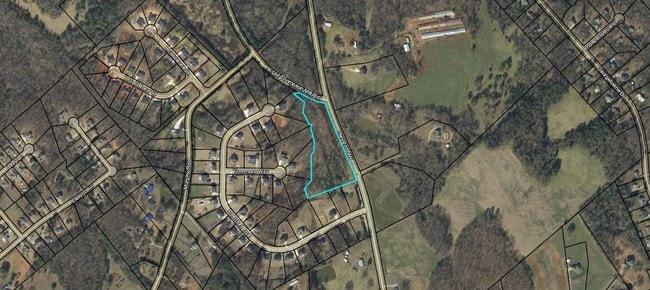
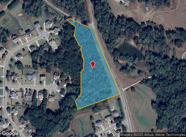
Highway 211 Nw
Atlanta-Sandy Springs-Roswell, GA
Cedar Ridge
XX048H-049
HIGHWAY 211 NW
Commercialacreage
Barrow
X
Georgia
13013C0045D
0
2024
5 AC
2024
Barrow County
180203
Atlanta
DEMOGRAPHICS near Highway 211 Nw
1 Mile
3 Mile
5 Mile
2024 Total Population
1,879
13,357
49,808
2029 Population
2,207
15,784
58,647
Pop Growth 2024-2029
+ 17.46%
+ 18.17%
+ 17.75%
Average Age
39
39
38
2024 Total Households
611
4,478
16,828
HH Growth 2024-2029
+ 17.68%
+ 18.29%
+ 17.82%
Median Household Inc
$95,061
$85,538
$82,959
Avg Household Size
3.00
2.90
2.90
2024 Avg HH Vehicles
3.00
2.00
2.00
Median Home Value
$272,435
$251,257
$269,652
Median Year Built
2001
1998
1998
Nearby Places
Map Layers
Map Styles
 Street
 Aerial
- Restaurants
- Banks
- Shops
- Fitness
- Groceries
SALE & LEASE HISTORY
LISTING DATE
SALE/LEASE

Feb 27, 2018
For Sale
Nearby Properties
Address
Land Use
TOTAL SIZE
Lot Size
Zoning
Address
Land Use
TOTAL SIZE
Lot Size
Zoning
572.63 AC
004
Address
Land Use
TOTAL SIZE
Lot Size
Zoning
76,768 SF
25 AC
R-1
Address
Land Use
TOTAL SIZE
Lot Size
Zoning
173.05 AC
004
Address
Land Use
TOTAL SIZE
Lot Size
Zoning
325 AC
R-3
Address
Land Use
TOTAL SIZE
Lot Size
Zoning
60,307 SF
33.40 AC
AG
Address
Land Use
TOTAL SIZE
Lot Size
Zoning
387.40 AC
AG
Address
Land Use
TOTAL SIZE
Lot Size
Zoning
9.80 AC
004
Address
Land Use
TOTAL SIZE
Lot Size
Zoning
1,680 SF
312.10 AC
AG
Address
Land Use
TOTAL SIZE
Lot Size
Zoning
74.20 AC
R1 C1
Address
Land Use
TOTAL SIZE
Lot Size
Zoning
5,433 SF
11.80 AC
AG
Address
Land Use
TOTAL SIZE
Lot Size
Zoning
178.60 AC
AG
Address
Land Use
TOTAL SIZE
Lot Size
Zoning
139.50 AC
M-2
Address
Land Use
TOTAL SIZE
Lot Size
Zoning
124 AC
M-2
Address
Land Use
TOTAL SIZE
Lot Size
Zoning
100.92 AC
004
Address
Land Use
TOTAL SIZE
Lot Size
Zoning
2,880 SF
33 AC
MH
Address
Land Use
TOTAL SIZE
Lot Size
Zoning
8,988 SF
1.70 AC
C-2
Address
Land Use
TOTAL SIZE
Lot Size
Zoning
126.40 AC
AG
Address
Land Use
TOTAL SIZE
Lot Size
Zoning
157.20 AC
AG
Address
Land Use
TOTAL SIZE
Lot Size
Zoning
50.60 AC
R-3
Address
Land Use
TOTAL SIZE
Lot Size
Zoning
40,164 SF
7.10 AC
AR
Address
Land Use
TOTAL SIZE
Lot Size
Zoning
112.60 AC
AG
Address
Land Use
TOTAL SIZE
Lot Size
Zoning
46.60 AC
R-3
Address
Land Use
TOTAL SIZE
Lot Size
Zoning
10,560 SF
1.10 AC
C-2
Address
Land Use
TOTAL SIZE
Lot Size
Zoning
155.20 AC
R-3
Address
Land Use
TOTAL SIZE
Lot Size
Zoning
78.70 AC
M-1
Address
Land Use
TOTAL SIZE
Lot Size
Zoning
22.54 AC
004
Address
Land Use
TOTAL SIZE
Lot Size
Zoning
6,373 SF
1.06 AC
C-2
Address
Land Use
TOTAL SIZE
Lot Size
Zoning
5,000 SF
2 AC
C-3
Address
Land Use
TOTAL SIZE
Lot Size
Zoning
76.20 AC
M-2
Address
Land Use
TOTAL SIZE
Lot Size
Zoning
123.40 AC
R-1
The World's #1 Commercial Real Estate Marketplace
Connect with us
© 2025 CoStar Group
The information above has been obtained from sources believed reliable. While we do not doubt its accuracy we have not verified it and make no guarantee, warranty or representation about it. It is your responsibility to independently confirm its accuracy and completeness. Any projections, opinions, assumptions, or estimates used are for example only and do not represent the current or future performance of the property. The value of this transaction to you depends on tax and other factors which should be evaluated by your tax, financial, and legal advisors. You and your advisors should conduct a careful, independent investigation of the property to determine to your satisfaction the suitability of the property for your needs.