Property Record
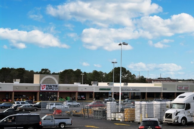
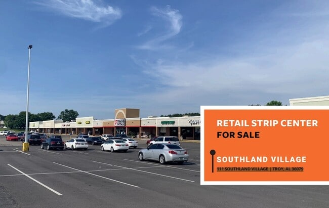
Highway 231, Troy, AL 36079
NEARBY LISTINGS FOR SALE OR LEASE
-
-
View all Troy listings for lease on LoopNet.com
Property Detail
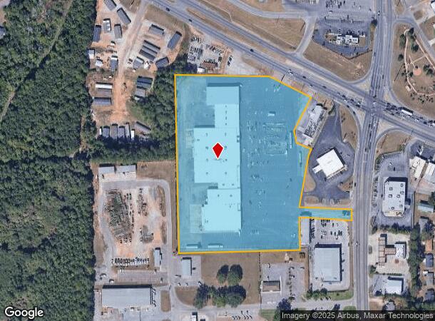
Highway 231
1703-0540110-010000
Section 5 Township 9 North Range 21 East
Retailwithmorethanonenonretailuse
11.06 A/C BEG AT ONTER OF N LINE OF NW/4 OF SE/4 SEC5 T9N R21E & R/W US HWY 231 TH SE205 SW170 S561 SE78.5 SW33.5 S240 E239.8
X
Pike
01109C0215C
Alabama
2025
11.06 AC
2025
Alabama South Area
189003
Other Market Areas
99,332 SF
Troy, AL
DEMOGRAPHICS near Highway 231
1 Mile
3 Mile
5 Mile
2024 Total Population
3,351
17,205
20,307
2029 Population
3,341
17,184
20,226
Pop Growth 2024-2029
(0.30%)
(0.12%)
(0.40%)
Average Age
34
35
36
2024 Total Households
1,348
7,091
8,412
HH Growth 2024-2029
+ 0.07%
+ 0.10%
(0.20%)
Median Household Inc
$32,243
$36,003
$37,960
Avg Household Size
2.00
2.10
2.10
2024 Avg HH Vehicles
2.00
2.00
2.00
Median Home Value
$169,545
$172,980
$174,820
Median Year Built
1985
1989
1989
Nearby Places
Map Layers
Map Styles
 Street
 Aerial
- Restaurants
- Banks
- Shops
- Fitness
- Groceries
SALE & LEASE HISTORY
LISTING DATE
SALE/LEASE

Sep 25, 2016
For Lease
Sep 07, 2023
For Sale
Nov 30, 2017
For Lease
Jan 16, 2024
For Lease
Feb 14, 2024
For Lease
Nearby Properties
Address
Land Use
TOTAL SIZE
Lot Size
Zoning
Address
Land Use
TOTAL SIZE
Lot Size
Zoning
14,100 SF
6.55 AC
C
Address
Land Use
TOTAL SIZE
Lot Size
Zoning
1,776 SF
9.72 AC
S
Address
Land Use
TOTAL SIZE
Lot Size
Zoning
7,551 SF
21 AC
S
Address
Land Use
TOTAL SIZE
Lot Size
Zoning
3,208 SF
12.97 AC
Address
Land Use
TOTAL SIZE
Lot Size
Zoning
2,960 SF
36.74 AC
C
Address
Land Use
TOTAL SIZE
Lot Size
Zoning
189,273 SF
21.24 AC
Address
Land Use
TOTAL SIZE
Lot Size
Zoning
23,200 SF
23.70 AC
I
Address
Land Use
TOTAL SIZE
Lot Size
Zoning
81,925 SF
5.19 AC
C
Address
Land Use
TOTAL SIZE
Lot Size
Zoning
480 SF
20.50 AC
C
Address
Land Use
TOTAL SIZE
Lot Size
Zoning
14,082 SF
0.36 AC
S
Address
Land Use
TOTAL SIZE
Lot Size
Zoning
111,427 SF
14.90 AC
Address
Land Use
TOTAL SIZE
Lot Size
Zoning
2,932 SF
6.50 AC
M
Address
Land Use
TOTAL SIZE
Lot Size
Zoning
70.29 AC
Address
Land Use
TOTAL SIZE
Lot Size
Zoning
5,363 SF
44.95 AC
Address
Land Use
TOTAL SIZE
Lot Size
Zoning
4.29 AC
N
Address
Land Use
TOTAL SIZE
Lot Size
Zoning
11,139 SF
2.50 AC
S
Address
Land Use
TOTAL SIZE
Lot Size
Zoning
6,000 SF
55 AC
I
Address
Land Use
TOTAL SIZE
Lot Size
Zoning
14,395 SF
2.18 AC
Address
Land Use
TOTAL SIZE
Lot Size
Zoning
20,590 SF
14.80 AC
C
Address
Land Use
TOTAL SIZE
Lot Size
Zoning
10,633 SF
2.79 AC
C
Address
Land Use
TOTAL SIZE
Lot Size
Zoning
13,855 SF
0.50 AC
S
Address
Land Use
TOTAL SIZE
Lot Size
Zoning
15,320 SF
1.88 AC
S
Address
Land Use
TOTAL SIZE
Lot Size
Zoning
6,888 SF
0.98 AC
S
Address
Land Use
TOTAL SIZE
Lot Size
Zoning
66,591 SF
8.78 AC
C
Address
Land Use
TOTAL SIZE
Lot Size
Zoning
12,645 SF
5.40 AC
C
Address
Land Use
TOTAL SIZE
Lot Size
Zoning
17,268 SF
3.96 AC
Address
Land Use
TOTAL SIZE
Lot Size
Zoning
41,250 SF
6 AC
Address
Land Use
TOTAL SIZE
Lot Size
Zoning
23,473 SF
11.01 AC
I
The World's #1 Commercial Real Estate Marketplace
Connect with us
© 2026 CoStar Group
The information above has been obtained from sources believed reliable. While we do not doubt its accuracy we have not verified it and make no guarantee, warranty or representation about it. It is your responsibility to independently confirm its accuracy and completeness. Any projections, opinions, assumptions, or estimates used are for example only and do not represent the current or future performance of the property. The value of this transaction to you depends on tax and other factors which should be evaluated by your tax, financial, and legal advisors. You and your advisors should conduct a careful, independent investigation of the property to determine to your satisfaction the suitability of the property for your needs.