Property Record
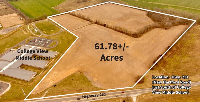
Highway 231, Utica, KY 42376

NEARBY LISTINGS FOR SALE OR LEASE
Property Detail
Highway 231
064-00-00-033-00-000
5061 NEW HARTFORD RD
Taxexempt
Daviess
AE
Kentucky
21059C0285E
49.13 AC
0
Kentucky West Area
2025
Other Market Areas
001703
Owensboro, KY
101,268 SF
DEMOGRAPHICS near Highway 231
1 Mile
3 Mile
5 Mile
2024 Total Population
671
24,482
65,729
2029 Population
672
24,633
66,055
Pop Growth 2024-2029
+ 0.15%
+ 0.62%
+ 0.50%
Average Age
41
40
40
2024 Total Households
246
10,136
26,871
HH Growth 2024-2029
0.00%
+ 0.57%
+ 0.51%
Median Household Inc
$98,511
$63,451
$57,430
Avg Household Size
2.60
2.30
2.30
2024 Avg HH Vehicles
2.00
2.00
2.00
Median Home Value
$245,754
$187,074
$168,531
Median Year Built
1977
1979
1972
Nearby Places
Map Layers
Map Styles
 Street
 Aerial
- Restaurants
- Banks
- Shops
- Fitness
- Groceries
SALE & LEASE HISTORY
LISTING DATE
SALE/LEASE

Mar 20, 2024
For Sale
Nearby Properties
Address
Land Use
TOTAL SIZE
Lot Size
Zoning
Address
Land Use
TOTAL SIZE
Lot Size
Zoning
4,361 SF
17.09 AC
Address
Land Use
TOTAL SIZE
Lot Size
Zoning
270,464 SF
100.67 AC
Address
Land Use
TOTAL SIZE
Lot Size
Zoning
227,450 SF
30.70 AC
Address
Land Use
TOTAL SIZE
Lot Size
Zoning
187,364 SF
18.64 AC
Address
Land Use
TOTAL SIZE
Lot Size
Zoning
165,207 SF
15.76 AC
Address
Land Use
TOTAL SIZE
Lot Size
Zoning
Address
Land Use
TOTAL SIZE
Lot Size
Zoning
67,431 SF
3.53 AC
Address
Land Use
TOTAL SIZE
Lot Size
Zoning
122,450 SF
7.63 AC
Address
Land Use
TOTAL SIZE
Lot Size
Zoning
193,067 SF
19.80 AC
Address
Land Use
TOTAL SIZE
Lot Size
Zoning
207,292 SF
17.74 AC
Address
Land Use
TOTAL SIZE
Lot Size
Zoning
85,349 SF
9.23 AC
Address
Land Use
TOTAL SIZE
Lot Size
Zoning
116,601 SF
15.72 AC
Address
Land Use
TOTAL SIZE
Lot Size
Zoning
17,920 SF
10.60 AC
Address
Land Use
TOTAL SIZE
Lot Size
Zoning
135,855 SF
18.24 AC
Address
Land Use
TOTAL SIZE
Lot Size
Zoning
63,050 SF
6.91 AC
Address
Land Use
TOTAL SIZE
Lot Size
Zoning
91,284 SF
9.99 AC
Address
Land Use
TOTAL SIZE
Lot Size
Zoning
58,573 SF
5.93 AC
Address
Land Use
TOTAL SIZE
Lot Size
Zoning
46,646 SF
3.53 AC
Address
Land Use
TOTAL SIZE
Lot Size
Zoning
11,486 SF
12.34 AC
Address
Land Use
TOTAL SIZE
Lot Size
Zoning
57,072 SF
6.28 AC
Address
Land Use
TOTAL SIZE
Lot Size
Zoning
3,026 SF
7.56 AC
Address
Land Use
TOTAL SIZE
Lot Size
Zoning
93,258 SF
13.42 AC
Address
Land Use
TOTAL SIZE
Lot Size
Zoning
8,232 SF
2.34 AC
Address
Land Use
TOTAL SIZE
Lot Size
Zoning
18,900 SF
3.09 AC
Address
Land Use
TOTAL SIZE
Lot Size
Zoning
89,400 SF
8.70 AC
Address
Land Use
TOTAL SIZE
Lot Size
Zoning
1,986 SF
2.38 AC
Address
Land Use
TOTAL SIZE
Lot Size
Zoning
19,457 SF
0.55 AC
Address
Land Use
TOTAL SIZE
Lot Size
Zoning
8,540 SF
92.72 AC
Address
Land Use
TOTAL SIZE
Lot Size
Zoning
The World's #1 Commercial Real Estate Marketplace
Connect with us
© 2025 CoStar Group
The information above has been obtained from sources believed reliable. While we do not doubt its accuracy we have not verified it and make no guarantee, warranty or representation about it. It is your responsibility to independently confirm its accuracy and completeness. Any projections, opinions, assumptions, or estimates used are for example only and do not represent the current or future performance of the property. The value of this transaction to you depends on tax and other factors which should be evaluated by your tax, financial, and legal advisors. You and your advisors should conduct a careful, independent investigation of the property to determine to your satisfaction the suitability of the property for your needs.