Property Record
Highway 242, Conroe, TX 77306
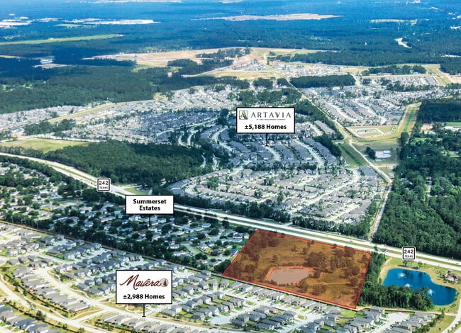

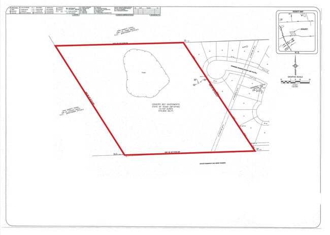
This Property Is For Sale
Property Detail
Highway 242
Houston-Pasadena-The Woodlands, TX
A0838 - PROSSER SS JR, TRACT 2, ACRES 13.1, MF-18746
0838-00-00101
MONTGOMERY
Vacantlandnec
Texas
B and X Area of moderate flood hazard, usually the area between the limits of the 100-year and 500-year floods.
13.10 AC
2024
Outlying Montgomery Cnty
2025
Houston
693002
NEARBY LISTINGS FOR SALE OR LEASE
DEMOGRAPHICS near Highway 242
1 mile
3 mile
5 mile
2025 Total Population
4,107
14,664
42,013
2030 Population
5,099
17,821
50,123
Pop Growth 2025-2030
+ 24.15%
+ 21.53%
+ 19.30%
Average Age
35
36
36
2025 Total Households
1,298
4,594
13,574
HH Growth 2025-2030
+ 24.35%
+ 21.90%
+ 19.80%
Median Household Inc
$90,542
$81,821
$85,422
Avg Household Size
3.10
3.10
3.00
2025 Avg HH Vehicles
2.00
2.00
2.00
Median Home Value
$361,231
$244,754
$268,921
Median Year Built
2010
2009
2010
Nearby Places
Map Layers
Map Styles
 Street
 Aerial
Transit
 Traffic
 Biking
Places
Listings with unknown addresses are not visible on the map
- Restaurants
- Banks
- Shops
- Fitness
- Groceries
PUBLIC TRANSPORTATION
AIRPORT
George Bush Intcntl/Houston
Drive
Walk
Distance
George Bush Intcntl/Houston
39 min
29.5 mi
Freight Ports
Port of Houston
Drive
Walk
Distance
Port of Houston
60 min
44.8 mi
Nearby Properties
Address
Land Use
TOTAL SIZE
Lot Size
Zoning
Address
Land Use
TOTAL SIZE
Lot Size
Zoning
205,948 SF
23.14 AC
Address
Land Use
TOTAL SIZE
Lot Size
Zoning
149,817 SF
2 AC
1
Address
Land Use
TOTAL SIZE
Lot Size
Zoning
98,000 SF
18 AC
Address
Land Use
TOTAL SIZE
Lot Size
Zoning
95,185 SF
10.48 AC
1
Address
Land Use
TOTAL SIZE
Lot Size
Zoning
18,308 SF
2.68 AC
1
Address
Land Use
TOTAL SIZE
Lot Size
Zoning
96,946 SF
12 AC
1
Address
Land Use
TOTAL SIZE
Lot Size
Zoning
86,584 SF
5.58 AC
Address
Land Use
TOTAL SIZE
Lot Size
Zoning
32,009 SF
13.32 AC
1
Address
Land Use
TOTAL SIZE
Lot Size
Zoning
6,286 SF
21.84 AC
Address
Land Use
TOTAL SIZE
Lot Size
Zoning
26,558 SF
12 AC
1
Address
Land Use
TOTAL SIZE
Lot Size
Zoning
29,314 SF
1.34 AC
1
Address
Land Use
TOTAL SIZE
Lot Size
Zoning
20,091 SF
12.04 AC
1
Address
Land Use
TOTAL SIZE
Lot Size
Zoning
9,146 SF
1.64 AC
1
Address
Land Use
TOTAL SIZE
Lot Size
Zoning
8.87 AC
1
Address
Land Use
TOTAL SIZE
Lot Size
Zoning
1,440 SF
12.81 AC
1
Address
Land Use
TOTAL SIZE
Lot Size
Zoning
12,880 SF
5.86 AC
1
Address
Land Use
TOTAL SIZE
Lot Size
Zoning
20,808 SF
14.80 AC
1
Address
Land Use
TOTAL SIZE
Lot Size
Zoning
25,364 SF
6.11 AC
1
Address
Land Use
TOTAL SIZE
Lot Size
Zoning
1,510 SF
6.49 AC
1
Address
Land Use
TOTAL SIZE
Lot Size
Zoning
16,701 SF
3.06 AC
1
Address
Land Use
TOTAL SIZE
Lot Size
Zoning
8,432 SF
13.67 AC
Address
Land Use
TOTAL SIZE
Lot Size
Zoning
10,440 SF
7.01 AC
1
Address
Land Use
TOTAL SIZE
Lot Size
Zoning
1,276 SF
1.35 AC
1
Address
Land Use
TOTAL SIZE
Lot Size
Zoning
9,000 SF
35.22 AC
1
Address
Land Use
TOTAL SIZE
Lot Size
Zoning
10,800 SF
5 AC
Address
Land Use
TOTAL SIZE
Lot Size
Zoning
14,993 SF
2.38 AC
1
Address
Land Use
TOTAL SIZE
Lot Size
Zoning
2,448 SF
20 AC
Address
Land Use
TOTAL SIZE
Lot Size
Zoning
15,004 SF
4.69 AC
1
Address
Land Use
TOTAL SIZE
Lot Size
Zoning
7,128 SF
2.20 AC
1
The World's #1 Commercial Real Estate Marketplace
Connect with us
© 2026 CoStar Group
The information above has been obtained from sources believed reliable. While we do not doubt its accuracy we have not verified it and make no guarantee, warranty or representation about it. It is your responsibility to independently confirm its accuracy and completeness. Any projections, opinions, assumptions, or estimates used are for example only and do not represent the current or future performance of the property. The value of this transaction to you depends on tax and other factors which should be evaluated by your tax, financial, and legal advisors. You and your advisors should conduct a careful, independent investigation of the property to determine to your satisfaction the suitability of the property for your needs.