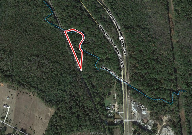
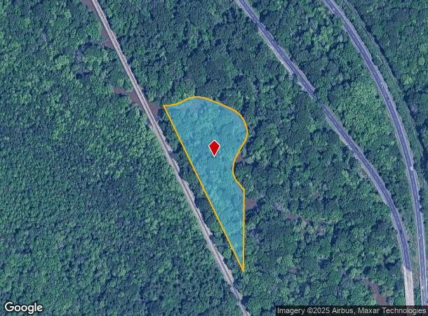
Property Record
Highway 247, Warner Robins, GA 31093
NEARBY LISTINGS FOR SALE OR LEASE
Property Detail
Highway 247
Warner Robins, GA
County Comm 1
000950038000
2.00 ACRES LL 186 5TH LD
Industrialacreage
Houston
AE
Georgia
13021C0265G
2 AC
2024
Perry/Warner Robins
2024
Other Market Areas
020111
DEMOGRAPHICS near Highway 247
1 Mile
3 Mile
5 Mile
2024 Total Population
411
20,203
54,296
2029 Population
450
22,173
59,419
Pop Growth 2024-2029
+ 9.49%
+ 9.75%
+ 9.44%
Average Age
40
38
38
2024 Total Households
182
8,053
21,462
HH Growth 2024-2029
+ 9.34%
+ 9.59%
+ 9.25%
Median Household Inc
$45,536
$45,424
$51,997
Avg Household Size
2.30
2.40
2.50
2024 Avg HH Vehicles
2.00
2.00
2.00
Median Home Value
$74,999
$96,526
$119,784
Median Year Built
1982
1975
1975
Nearby Places
Map Layers
Map Styles
 Street
 Aerial
- Restaurants
- Banks
- Shops
- Fitness
- Groceries
SALE & LEASE HISTORY
LISTING DATE
SALE/LEASE

Sep 24, 2016
For Sale
Nearby Properties
Address
Land Use
TOTAL SIZE
Lot Size
Zoning
Address
Land Use
TOTAL SIZE
Lot Size
Zoning
17,952 SF
1,075.78 AC
M-1
Address
Land Use
TOTAL SIZE
Lot Size
Zoning
780,000 SF
70.50 AC
M-2
Address
Land Use
TOTAL SIZE
Lot Size
Zoning
560,025 SF
79.35 AC
M-1
Address
Land Use
TOTAL SIZE
Lot Size
Zoning
11,658 SF
30.23 AC
R2
Address
Land Use
TOTAL SIZE
Lot Size
Zoning
11,200 SF
7.60 AC
R4
Address
Land Use
TOTAL SIZE
Lot Size
Zoning
6,336 SF
27.16 AC
R4
Address
Land Use
TOTAL SIZE
Lot Size
Zoning
194,390 SF
242 AC
A
Address
Land Use
TOTAL SIZE
Lot Size
Zoning
128,540 SF
32.26 AC
R2
Address
Land Use
TOTAL SIZE
Lot Size
Zoning
20,252 SF
22.87 AC
A
Address
Land Use
TOTAL SIZE
Lot Size
Zoning
90,000 SF
12 AC
R1
Address
Land Use
TOTAL SIZE
Lot Size
Zoning
61,628 SF
45 AC
C2
Address
Land Use
TOTAL SIZE
Lot Size
Zoning
121,500 SF
10 AC
R2
Address
Land Use
TOTAL SIZE
Lot Size
Zoning
4,720 SF
12.53 AC
C2
Address
Land Use
TOTAL SIZE
Lot Size
Zoning
4,720 SF
8.66 AC
C2
Address
Land Use
TOTAL SIZE
Lot Size
Zoning
2,880 SF
16.49 AC
PUD
Address
Land Use
TOTAL SIZE
Lot Size
Zoning
3,200 SF
17.67 AC
R2
Address
Land Use
TOTAL SIZE
Lot Size
Zoning
3,264 SF
18.35 AC
R4
Address
Land Use
TOTAL SIZE
Lot Size
Zoning
3,139 SF
10.85 AC
R4
Address
Land Use
TOTAL SIZE
Lot Size
Zoning
4,000 SF
13.72 AC
R4
Address
Land Use
TOTAL SIZE
Lot Size
Zoning
2,583 SF
15.25 AC
R4
Address
Land Use
TOTAL SIZE
Lot Size
Zoning
49,520 SF
10.32 AC
R2
Address
Land Use
TOTAL SIZE
Lot Size
Zoning
4,234 SF
8.30 AC
R4
Address
Land Use
TOTAL SIZE
Lot Size
Zoning
7,896 SF
7.71 AC
R4
Address
Land Use
TOTAL SIZE
Lot Size
Zoning
9,380 SF
4.06 AC
R2
Address
Land Use
TOTAL SIZE
Lot Size
Zoning
43,247 SF
5.24 AC
C2
Address
Land Use
TOTAL SIZE
Lot Size
Zoning
14,300 SF
7 AC
R2
Address
Land Use
TOTAL SIZE
Lot Size
Zoning
2,418 SF
8.45 AC
C2
Address
Land Use
TOTAL SIZE
Lot Size
Zoning
24,449 SF
10.01 AC
C2
Address
Land Use
TOTAL SIZE
Lot Size
Zoning
60,000 SF
6.12 AC
M1
Address
Land Use
TOTAL SIZE
Lot Size
Zoning
12,700 SF
3.09 AC
C2
The World's #1 Commercial Real Estate Marketplace
Connect with us
© 2025 CoStar Group
The information above has been obtained from sources believed reliable. While we do not doubt its accuracy we have not verified it and make no guarantee, warranty or representation about it. It is your responsibility to independently confirm its accuracy and completeness. Any projections, opinions, assumptions, or estimates used are for example only and do not represent the current or future performance of the property. The value of this transaction to you depends on tax and other factors which should be evaluated by your tax, financial, and legal advisors. You and your advisors should conduct a careful, independent investigation of the property to determine to your satisfaction the suitability of the property for your needs.