Property Record
Highway 25 N, Millen, GA 30442

Property Detail
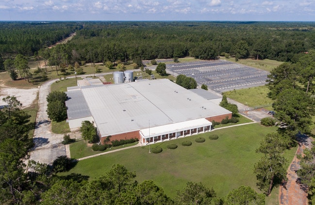
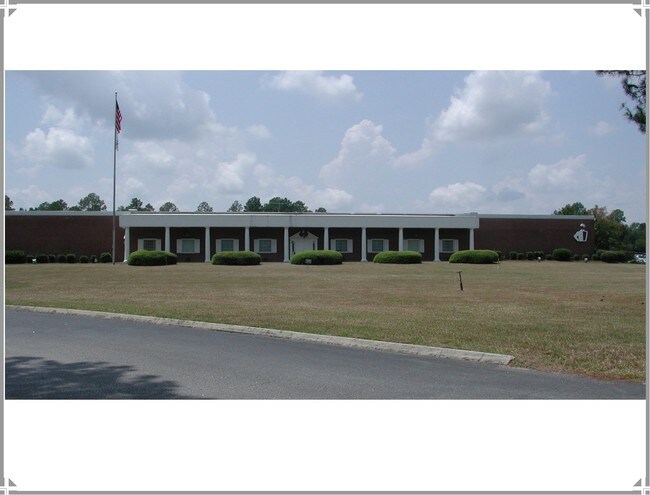
Highway 25 N
Manufacturinglight
46.06 AC W SIDE #25 N (JOCKEY PLANT BUILDING)
INDUSTRIAL
JENKINS
AE The base floodplain where base flood elevations are provided. AE Zones are now used on new format FIRMs instead of A1-A30 Zones.
Georgia
0
46.06 AC
2025
Georgia South Area
960100
Other Market Areas
94,461 SF
M18-042
NEARBY LISTINGS FOR SALE OR LEASE
-
-
View all Millen listings for lease on LoopNet.com
DEMOGRAPHICS near Highway 25 N
1 mile
3 mile
5 mile
2025 Total Population
746
4,503
5,343
2030 Population
739
4,504
5,355
Pop Growth 2025-2030
(0.94%)
+ 0.02%
+ 0.22%
Average Age
43
42
42
2025 Total Households
322
1,529
1,810
HH Growth 2025-2030
(0.62%)
(0.33%)
(0.11%)
Median Household Inc
$39,736
$36,317
$36,450
Avg Household Size
2.20
2.30
2.30
2025 Avg HH Vehicles
2.00
2.00
2.00
Median Home Value
$74,999
$81,693
$83,435
Median Year Built
1976
1976
1976
Nearby Places
Map Layers
Map Styles
 Street
 Aerial
Layers
 Traffic
 Biking
Places
Listings with unknown addresses are not visible on the map
- Restaurants
- Banks
- Shops
- Fitness
- Groceries
SALE & LEASE HISTORY
LISTING DATE
SALE/LEASE

Oct 26, 2016
For Sale
Jul 30, 2018
For Lease
Jul 30, 2018
For Sale
Jul 30, 2018
For Sale
Nearby Properties
Address
Land Use
TOTAL SIZE
Lot Size
Zoning
Address
Land Use
TOTAL SIZE
Lot Size
Zoning
54,135 SF
100.53 AC
RURAL
Address
Land Use
TOTAL SIZE
Lot Size
Zoning
226,804 SF
29.52 AC
UNZONED UR
Address
Land Use
TOTAL SIZE
Lot Size
Zoning
110,954 SF
18.40 AC
UNZONED SM
Address
Land Use
TOTAL SIZE
Lot Size
Zoning
31,714 SF
4.80 AC
UNZONED UR
Address
Land Use
TOTAL SIZE
Lot Size
Zoning
21,180 SF
0.91 AC
COMMERCIAL
Address
Land Use
TOTAL SIZE
Lot Size
Zoning
33,751 SF
5.60 AC
UNZONED UR
Address
Land Use
TOTAL SIZE
Lot Size
Zoning
33,600 SF
18.95 AC
INDUSTRIAL
Address
Land Use
TOTAL SIZE
Lot Size
Zoning
13,188 SF
2.04 AC
RESIDENTIA
Address
Land Use
TOTAL SIZE
Lot Size
Zoning
6,500 SF
9.73 AC
INDUSTRIAL
Address
Land Use
TOTAL SIZE
Lot Size
Zoning
16,040 SF
0.54 AC
UNZONED UR
Address
Land Use
TOTAL SIZE
Lot Size
Zoning
13,644 SF
5.74 AC
INDUSTRIAL
Address
Land Use
TOTAL SIZE
Lot Size
Zoning
60,000 SF
4.28 AC
Address
Land Use
TOTAL SIZE
Lot Size
Zoning
1,896 SF
5.31 AC
UNZONED UR
Address
Land Use
TOTAL SIZE
Lot Size
Zoning
13,530 SF
2.79 AC
RURAL
Address
Land Use
TOTAL SIZE
Lot Size
Zoning
832 SF
20 AC
RESIDENTIA
Address
Land Use
TOTAL SIZE
Lot Size
Zoning
7,649 SF
1.50 AC
COMMERCIAL
Address
Land Use
TOTAL SIZE
Lot Size
Zoning
4,878 SF
1.95 AC
UNZONED UR
Address
Land Use
TOTAL SIZE
Lot Size
Zoning
6,536 SF
1.46 AC
COMMERCIAL
Address
Land Use
TOTAL SIZE
Lot Size
Zoning
6,788 SF
0.50 AC
RESIDENTIA
Address
Land Use
TOTAL SIZE
Lot Size
Zoning
4,004 SF
1.62 AC
UNZONED UR
Address
Land Use
TOTAL SIZE
Lot Size
Zoning
1,827 SF
4.91 AC
COMMERCIAL
Address
Land Use
TOTAL SIZE
Lot Size
Zoning
1,248 SF
380.44 AC
RURAL
Address
Land Use
TOTAL SIZE
Lot Size
Zoning
3,572 SF
1.59 AC
COMMERCIAL
Address
Land Use
TOTAL SIZE
Lot Size
Zoning
407.07 AC
RURAL
Address
Land Use
TOTAL SIZE
Lot Size
Zoning
6,164 SF
0.53 AC
UNZONED UR
Address
Land Use
TOTAL SIZE
Lot Size
Zoning
7,308 SF
11.70 AC
COMMERCIAL
Address
Land Use
TOTAL SIZE
Lot Size
Zoning
22,392 SF
2.08 AC
UNZONED UR
Address
Land Use
TOTAL SIZE
Lot Size
Zoning
7,103 SF
1.02 AC
UNZONED UR
The World's #1 Commercial Real Estate Marketplace
Connect with us
© 2026 CoStar Group
The information above has been obtained from sources believed reliable. While we do not doubt its accuracy we have not verified it and make no guarantee, warranty or representation about it. It is your responsibility to independently confirm its accuracy and completeness. Any projections, opinions, assumptions, or estimates used are for example only and do not represent the current or future performance of the property. The value of this transaction to you depends on tax and other factors which should be evaluated by your tax, financial, and legal advisors. You and your advisors should conduct a careful, independent investigation of the property to determine to your satisfaction the suitability of the property for your needs.