Property Record
Highway 27, Davenport, FL 33896
NEARBY LISTINGS FOR SALE OR LEASE
Property Detail
Highway 27
Lakeland-Winter Haven, FL
Dunson 27 Commercial Park
27-26-07-701257-000010
DUNSON 27 COMMERCIAL PARK PB 123 PGS 22 & 23 LOT 1
Commercialacreage
Polk
X
Florida
12105C0225G
1
2024
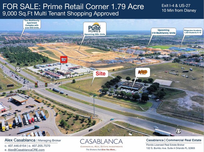
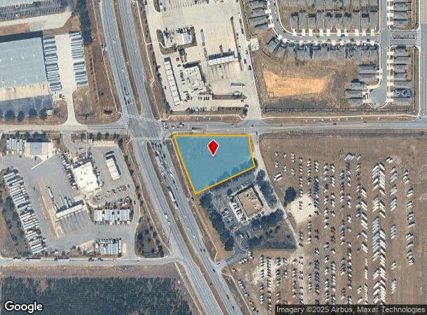
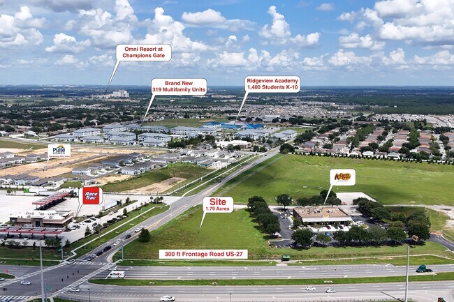
1.79 AC
2025
Polk County
012506
Tampa/St Petersburg
DEMOGRAPHICS near Highway 27
1 Mile
3 Mile
5 Mile
2024 Total Population
3,840
37,674
80,711
2029 Population
4,868
47,275
101,112
Pop Growth 2024-2029
+ 26.77%
+ 25.48%
+ 25.28%
Average Age
40
40
39
2024 Total Households
1,433
14,052
29,394
HH Growth 2024-2029
+ 26.87%
+ 25.60%
+ 25.37%
Median Household Inc
$72,599
$71,998
$67,339
Avg Household Size
2.60
2.60
2.70
2024 Avg HH Vehicles
2.00
2.00
2.00
Median Home Value
$265,203
$260,079
$260,918
Median Year Built
2009
2008
2007
Nearby Places
Map Layers
Map Styles
 Street
 Aerial
- Restaurants
- Banks
- Shops
- Fitness
- Groceries
PUBLIC TRANSPORTATION
AIRPORT
Orlando International
DRIVE
WALK
Distance
Orlando International
34 min
30.4 mi
Freight Ports
Port of Tampa Bay
DRIVE
WALK
Distance
Port of Tampa Bay
1 min
52.4 mi
SALE & LEASE HISTORY
LISTING DATE
SALE/LEASE

Jan 16, 2023
For Sale
Dec 06, 2023
For Lease
Nearby Properties
Address
Land Use
TOTAL SIZE
Lot Size
Zoning
Address
Land Use
TOTAL SIZE
Lot Size
Zoning
736,399 SF
23.59 AC
OPD
Address
Land Use
TOTAL SIZE
Lot Size
Zoning
1,125,150 SF
51.12 AC
RC
Address
Land Use
TOTAL SIZE
Lot Size
Zoning
969,150 SF
91.98 AC
RC
Address
Land Use
TOTAL SIZE
Lot Size
Zoning
295,034 SF
14.25 AC
Address
Land Use
TOTAL SIZE
Lot Size
Zoning
422,457 SF
17.46 AC
Address
Land Use
TOTAL SIZE
Lot Size
Zoning
336,380 SF
19.05 AC
Address
Land Use
TOTAL SIZE
Lot Size
Zoning
380,530 SF
18.92 AC
RC
Address
Land Use
TOTAL SIZE
Lot Size
Zoning
480,104 SF
12.37 AC
Address
Land Use
TOTAL SIZE
Lot Size
Zoning
403,448 SF
14.96 AC
Address
Land Use
TOTAL SIZE
Lot Size
Zoning
322,095 SF
16.88 AC
Address
Land Use
TOTAL SIZE
Lot Size
Zoning
301,623 SF
20.06 AC
Address
Land Use
TOTAL SIZE
Lot Size
Zoning
412,886 SF
10.72 AC
Address
Land Use
TOTAL SIZE
Lot Size
Zoning
372,655 SF
17.06 AC
C5
Address
Land Use
TOTAL SIZE
Lot Size
Zoning
354,600 SF
14.93 AC
Address
Land Use
TOTAL SIZE
Lot Size
Zoning
308,973 SF
18.38 AC
Address
Land Use
TOTAL SIZE
Lot Size
Zoning
479,776 SF
20.90 AC
Address
Land Use
TOTAL SIZE
Lot Size
Zoning
360,270 SF
16.97 AC
OPD
Address
Land Use
TOTAL SIZE
Lot Size
Zoning
328,817 SF
12.62 AC
Address
Land Use
TOTAL SIZE
Lot Size
Zoning
491,027 SF
18.81 AC
RC
Address
Land Use
TOTAL SIZE
Lot Size
Zoning
601,750 SF
32.69 AC
Address
Land Use
TOTAL SIZE
Lot Size
Zoning
256,589 SF
15.37 AC
OPD
Address
Land Use
TOTAL SIZE
Lot Size
Zoning
450,000 SF
34.23 AC
Address
Land Use
TOTAL SIZE
Lot Size
Zoning
236,745 SF
26.56 AC
Address
Land Use
TOTAL SIZE
Lot Size
Zoning
406,208 SF
59.48 AC
Address
Land Use
TOTAL SIZE
Lot Size
Zoning
404,725 SF
26.87 AC
Address
Land Use
TOTAL SIZE
Lot Size
Zoning
192,257 SF
5.79 AC
Address
Land Use
TOTAL SIZE
Lot Size
Zoning
319,770 SF
40.72 AC
XX
Address
Land Use
TOTAL SIZE
Lot Size
Zoning
447,000 SF
23.26 AC
Address
Land Use
TOTAL SIZE
Lot Size
Zoning
398,850 SF
21.96 AC
Address
Land Use
TOTAL SIZE
Lot Size
Zoning
394,505 SF
25.69 AC
The World's #1 Commercial Real Estate Marketplace
Connect with us
© 2025 CoStar Group
The information above has been obtained from sources believed reliable. While we do not doubt its accuracy we have not verified it and make no guarantee, warranty or representation about it. It is your responsibility to independently confirm its accuracy and completeness. Any projections, opinions, assumptions, or estimates used are for example only and do not represent the current or future performance of the property. The value of this transaction to you depends on tax and other factors which should be evaluated by your tax, financial, and legal advisors. You and your advisors should conduct a careful, independent investigation of the property to determine to your satisfaction the suitability of the property for your needs.