Property Record
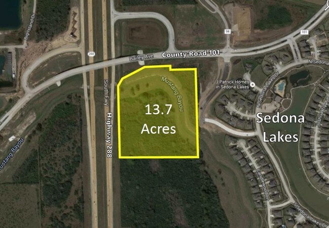
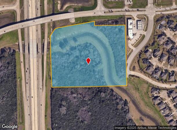
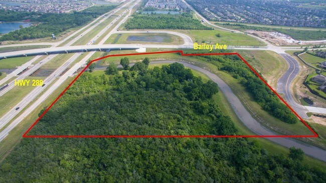
Highway 288 Cr 101, Manvel, TX 77578
NEARBY LISTINGS FOR SALE OR LEASE
Property Detail
Highway 288 Cr 101
Houston-The Woodlands-Sugar Land, TX
A C H & B
0417-0030-000
A0417 A C H & B TRACT 51A-52 (PT) (UND/2) ACRES 6.8479
Agriculturalland
Brazoria
AE
Texas
48039C0020K
6.85 AC
2024
South
2025
Houston
660708
DEMOGRAPHICS near Highway 288 Cr 101
1 Mile
3 Mile
5 Mile
2024 Total Population
8,787
62,932
137,141
2029 Population
9,785
70,145
154,575
Pop Growth 2024-2029
+ 11.36%
+ 11.46%
+ 12.71%
Average Age
35
35
36
2024 Total Households
3,005
20,316
45,297
HH Growth 2024-2029
+ 11.48%
+ 11.51%
+ 12.75%
Median Household Inc
$134,055
$119,535
$107,740
Avg Household Size
2.90
3.00
3.00
2024 Avg HH Vehicles
2.00
2.00
2.00
Median Home Value
$350,328
$340,419
$316,981
Median Year Built
2008
2007
2007
Nearby Places
Map Layers
Map Styles
 Street
 Aerial
- Restaurants
- Banks
- Shops
- Fitness
- Groceries
PUBLIC TRANSPORTATION
AIRPORT
William P Hobby
DRIVE
WALK
Distance
William P Hobby
27 min
14.7 mi
Freight Ports
Port of Houston
DRIVE
WALK
Distance
Port of Houston
32 min
21.4 mi
SALE & LEASE HISTORY
LISTING DATE
SALE/LEASE

Apr 12, 2019
For Sale
Apr 11, 2017
For Sale
Nearby Properties
Address
Land Use
TOTAL SIZE
Lot Size
Zoning
Address
Land Use
TOTAL SIZE
Lot Size
Zoning
241,351 SF
60.11 AC
Address
Land Use
TOTAL SIZE
Lot Size
Zoning
367,766 SF
43.71 AC
Address
Land Use
TOTAL SIZE
Lot Size
Zoning
42,360 SF
13.01 AC
Address
Land Use
TOTAL SIZE
Lot Size
Zoning
369,539 SF
30.71 AC
Address
Land Use
TOTAL SIZE
Lot Size
Zoning
372,209 SF
17.91 AC
Address
Land Use
TOTAL SIZE
Lot Size
Zoning
373,654 SF
16.35 AC
Address
Land Use
TOTAL SIZE
Lot Size
Zoning
372,280 SF
14.70 AC
0021
Address
Land Use
TOTAL SIZE
Lot Size
Zoning
412,375 SF
22.57 AC
Address
Land Use
TOTAL SIZE
Lot Size
Zoning
319,173 SF
7.67 AC
Address
Land Use
TOTAL SIZE
Lot Size
Zoning
321,409 SF
13.90 AC
Address
Land Use
TOTAL SIZE
Lot Size
Zoning
334,628 SF
13.87 AC
Address
Land Use
TOTAL SIZE
Lot Size
Zoning
323,168 SF
12.80 AC
Address
Land Use
TOTAL SIZE
Lot Size
Zoning
379,493 SF
14.27 AC
Address
Land Use
TOTAL SIZE
Lot Size
Zoning
225,854 SF
10.44 AC
Address
Land Use
TOTAL SIZE
Lot Size
Zoning
240,616 SF
10.01 AC
Address
Land Use
TOTAL SIZE
Lot Size
Zoning
66,998 SF
11.34 AC
Address
Land Use
TOTAL SIZE
Lot Size
Zoning
115,423 SF
12.13 AC
Address
Land Use
TOTAL SIZE
Lot Size
Zoning
241,488 SF
9.81 AC
Address
Land Use
TOTAL SIZE
Lot Size
Zoning
215,063 SF
19.13 AC
Address
Land Use
TOTAL SIZE
Lot Size
Zoning
228,276 SF
9.43 AC
0036
Address
Land Use
TOTAL SIZE
Lot Size
Zoning
106,627 SF
8.40 AC
Address
Land Use
TOTAL SIZE
Lot Size
Zoning
172,256 SF
6.13 AC
Address
Land Use
TOTAL SIZE
Lot Size
Zoning
66,060 SF
12.85 AC
0016
Address
Land Use
TOTAL SIZE
Lot Size
Zoning
81,170 SF
50 AC
Address
Land Use
TOTAL SIZE
Lot Size
Zoning
79,587 SF
5 AC
Address
Land Use
TOTAL SIZE
Lot Size
Zoning
84,604 SF
8.29 AC
0039
Address
Land Use
TOTAL SIZE
Lot Size
Zoning
70,033 SF
17.97 AC
Address
Land Use
TOTAL SIZE
Lot Size
Zoning
107,915 SF
9.29 AC
Address
Land Use
TOTAL SIZE
Lot Size
Zoning
58,985 SF
4.34 AC
Address
Land Use
TOTAL SIZE
Lot Size
Zoning
103,316 SF
The World's #1 Commercial Real Estate Marketplace
Connect with us
© 2025 CoStar Group
The information above has been obtained from sources believed reliable. While we do not doubt its accuracy we have not verified it and make no guarantee, warranty or representation about it. It is your responsibility to independently confirm its accuracy and completeness. Any projections, opinions, assumptions, or estimates used are for example only and do not represent the current or future performance of the property. The value of this transaction to you depends on tax and other factors which should be evaluated by your tax, financial, and legal advisors. You and your advisors should conduct a careful, independent investigation of the property to determine to your satisfaction the suitability of the property for your needs.