Property Record
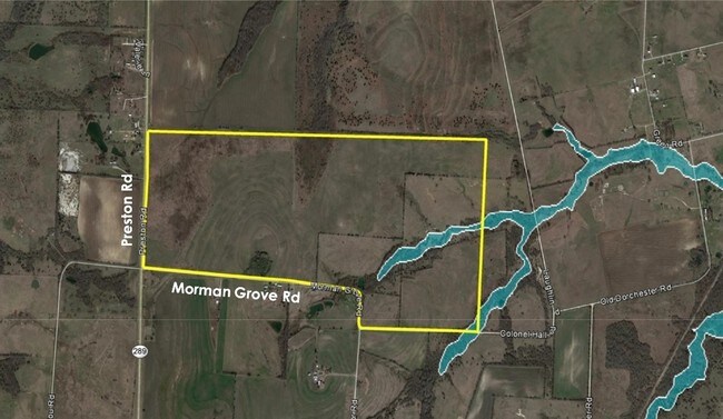
Highway 289 & Mormon Grove, Sherman, TX 75092
NEARBY LISTINGS FOR SALE OR LEASE
Property Detail
Highway 289 & Mormon Grove
Sherman-Denison, TX
Hernandez A A-G0488
127706
G-0488 HERNANDEZ A A-G0488, ACRES 148.629
Agriculturalland
Grayson
X
Texas
48181C0400G
148.63 AC
2024
Texas East Area
2025
Other Market Areas
001101
DEMOGRAPHICS near Highway 289 & Mormon Grove
1 Mile
3 Mile
5 Mile
2024 Total Population
97
1,179
7,987
2029 Population
109
1,323
9,069
Pop Growth 2024-2029
+ 12.37%
+ 12.21%
+ 13.55%
Average Age
40
40
39
2024 Total Households
35
417
3,179
HH Growth 2024-2029
+ 11.43%
+ 12.71%
+ 14.16%
Median Household Inc
$106,250
$84,756
$62,482
Avg Household Size
2.70
2.80
2.50
2024 Avg HH Vehicles
2.00
2.00
2.00
Median Home Value
$212,500
$239,333
$252,142
Median Year Built
2000
1997
1997
Nearby Places
Map Layers
Map Styles
 Street
 Aerial
- Restaurants
- Banks
- Shops
- Fitness
- Groceries
SALE & LEASE HISTORY
LISTING DATE
SALE/LEASE

Jan 27, 2017
For Sale
Nearby Properties
Address
Land Use
TOTAL SIZE
Lot Size
Zoning
Address
Land Use
TOTAL SIZE
Lot Size
Zoning
30,704 SF
38.87 AC
Address
Land Use
TOTAL SIZE
Lot Size
Zoning
6,404 SF
21 AC
Address
Land Use
TOTAL SIZE
Lot Size
Zoning
5,591 SF
70.43 AC
Address
Land Use
TOTAL SIZE
Lot Size
Zoning
3,200 SF
17.32 AC
Address
Land Use
TOTAL SIZE
Lot Size
Zoning
3,084 SF
20 AC
Address
Land Use
TOTAL SIZE
Lot Size
Zoning
3,184 SF
98.36 AC
Address
Land Use
TOTAL SIZE
Lot Size
Zoning
3,693 SF
127.74 AC
Address
Land Use
TOTAL SIZE
Lot Size
Zoning
3,574 SF
30.50 AC
Address
Land Use
TOTAL SIZE
Lot Size
Zoning
15,404 SF
4.93 AC
Address
Land Use
TOTAL SIZE
Lot Size
Zoning
5.54 AC
Address
Land Use
TOTAL SIZE
Lot Size
Zoning
9,872 SF
2.02 AC
Address
Land Use
TOTAL SIZE
Lot Size
Zoning
3,938 SF
145 AC
Address
Land Use
TOTAL SIZE
Lot Size
Zoning
2,510 SF
30.50 AC
Address
Land Use
TOTAL SIZE
Lot Size
Zoning
4,200 SF
0.26 AC
Address
Land Use
TOTAL SIZE
Lot Size
Zoning
1,924 SF
100 AC
Address
Land Use
TOTAL SIZE
Lot Size
Zoning
33.98 AC
Address
Land Use
TOTAL SIZE
Lot Size
Zoning
64 SF
1.50 AC
Address
Land Use
TOTAL SIZE
Lot Size
Zoning
4.12 AC
Address
Land Use
TOTAL SIZE
Lot Size
Zoning
1,920 SF
2 AC
Address
Land Use
TOTAL SIZE
Lot Size
Zoning
2,432 SF
3.90 AC
Address
Land Use
TOTAL SIZE
Lot Size
Zoning
4.60 AC
Address
Land Use
TOTAL SIZE
Lot Size
Zoning
2,230 SF
3.03 AC
Address
Land Use
TOTAL SIZE
Lot Size
Zoning
Address
Land Use
TOTAL SIZE
Lot Size
Zoning
2.98 AC
Address
Land Use
TOTAL SIZE
Lot Size
Zoning
1,204 SF
60 AC
Address
Land Use
TOTAL SIZE
Lot Size
Zoning
1,756 SF
31.07 AC
Address
Land Use
TOTAL SIZE
Lot Size
Zoning
2,000 SF
6.55 AC
Address
Land Use
TOTAL SIZE
Lot Size
Zoning
2.66 AC
Address
Land Use
TOTAL SIZE
Lot Size
Zoning
2.29 AC
Address
Land Use
TOTAL SIZE
Lot Size
Zoning
7,200 SF
18.23 AC
The World's #1 Commercial Real Estate Marketplace
Connect with us
© 2025 CoStar Group
The information above has been obtained from sources believed reliable. While we do not doubt its accuracy we have not verified it and make no guarantee, warranty or representation about it. It is your responsibility to independently confirm its accuracy and completeness. Any projections, opinions, assumptions, or estimates used are for example only and do not represent the current or future performance of the property. The value of this transaction to you depends on tax and other factors which should be evaluated by your tax, financial, and legal advisors. You and your advisors should conduct a careful, independent investigation of the property to determine to your satisfaction the suitability of the property for your needs.