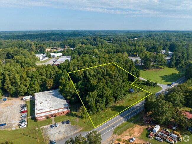
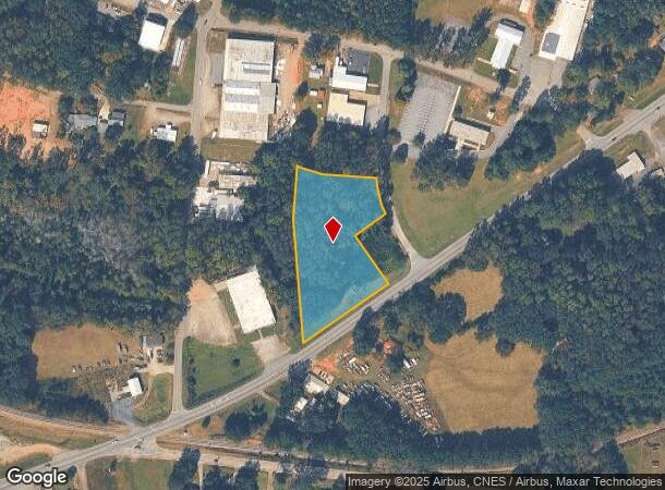
Property Record
Highway 29 Dr, Anderson, SC 29621

NEARBY LISTINGS FOR SALE OR LEASE
Property Detail
Highway 29 Dr
Greenville-Anderson-Mauldin, SC
CP 071/113 F306 D509 LTS 17 + 19 HWY 29 2.00AC
150-11-03-009
Anderson
Commercialacreage
South Carolina
X
17,19
45007C0401E
2 AC
2025
Anderson County
2024
Greenville/Spartanburg
000300
DEMOGRAPHICS near Highway 29 Dr
1 Mile
3 Mile
5 Mile
2024 Total Population
3,626
32,449
65,694
2029 Population
3,876
34,910
70,573
Pop Growth 2024-2029
+ 6.89%
+ 7.58%
+ 7.43%
Average Age
36
39
40
2024 Total Households
1,397
12,703
26,139
HH Growth 2024-2029
+ 6.94%
+ 7.75%
+ 7.54%
Median Household Inc
$33,791
$39,877
$45,436
Avg Household Size
2.50
2.30
2.40
2024 Avg HH Vehicles
2.00
2.00
2.00
Median Home Value
$136,818
$142,968
$151,499
Median Year Built
1973
1975
1978
Nearby Places
Map Layers
Map Styles
 Street
 Aerial
- Restaurants
- Banks
- Shops
- Fitness
- Groceries
SALE & LEASE HISTORY
LISTING DATE
SALE/LEASE

Jun 27, 2022
For Sale
Nearby Properties
Address
Land Use
TOTAL SIZE
Lot Size
Zoning
Address
Land Use
TOTAL SIZE
Lot Size
Zoning
17,286 SF
19.71 AC
Address
Land Use
TOTAL SIZE
Lot Size
Zoning
13,220 SF
13.49 AC
Address
Land Use
TOTAL SIZE
Lot Size
Zoning
15,168 SF
11.99 AC
Address
Land Use
TOTAL SIZE
Lot Size
Zoning
7,568 SF
10.99 AC
Address
Land Use
TOTAL SIZE
Lot Size
Zoning
45,014 SF
0.29 AC
Address
Land Use
TOTAL SIZE
Lot Size
Zoning
3,920 SF
20.13 AC
Address
Land Use
TOTAL SIZE
Lot Size
Zoning
40,071 SF
18.83 AC
Address
Land Use
TOTAL SIZE
Lot Size
Zoning
61,281 SF
0.74 AC
Address
Land Use
TOTAL SIZE
Lot Size
Zoning
91,698 SF
10.04 AC
Address
Land Use
TOTAL SIZE
Lot Size
Zoning
0.74 AC
Address
Land Use
TOTAL SIZE
Lot Size
Zoning
110,140 SF
6 AC
Address
Land Use
TOTAL SIZE
Lot Size
Zoning
80,205 SF
9.58 AC
Address
Land Use
TOTAL SIZE
Lot Size
Zoning
149,148 SF
16.87 AC
Address
Land Use
TOTAL SIZE
Lot Size
Zoning
46,410 SF
4.88 AC
Address
Land Use
TOTAL SIZE
Lot Size
Zoning
24.90 AC
Address
Land Use
TOTAL SIZE
Lot Size
Zoning
9,406 SF
7.92 AC
Address
Land Use
TOTAL SIZE
Lot Size
Zoning
44,568 SF
2.47 AC
Address
Land Use
TOTAL SIZE
Lot Size
Zoning
1,408 SF
20.24 AC
Address
Land Use
TOTAL SIZE
Lot Size
Zoning
2,315 SF
Address
Land Use
TOTAL SIZE
Lot Size
Zoning
14,656 SF
1.93 AC
Address
Land Use
TOTAL SIZE
Lot Size
Zoning
44,358 SF
6.25 AC
Address
Land Use
TOTAL SIZE
Lot Size
Zoning
22,220 SF
5.06 AC
Address
Land Use
TOTAL SIZE
Lot Size
Zoning
14,749 SF
1.58 AC
Address
Land Use
TOTAL SIZE
Lot Size
Zoning
3,080 SF
1.04 AC
Address
Land Use
TOTAL SIZE
Lot Size
Zoning
28.04 AC
Address
Land Use
TOTAL SIZE
Lot Size
Zoning
24,661 SF
41.82 AC
Address
Land Use
TOTAL SIZE
Lot Size
Zoning
361 SF
9.69 AC
Address
Land Use
TOTAL SIZE
Lot Size
Zoning
19,728 SF
2.23 AC
The World's #1 Commercial Real Estate Marketplace
Connect with us
© 2025 CoStar Group
The information above has been obtained from sources believed reliable. While we do not doubt its accuracy we have not verified it and make no guarantee, warranty or representation about it. It is your responsibility to independently confirm its accuracy and completeness. Any projections, opinions, assumptions, or estimates used are for example only and do not represent the current or future performance of the property. The value of this transaction to you depends on tax and other factors which should be evaluated by your tax, financial, and legal advisors. You and your advisors should conduct a careful, independent investigation of the property to determine to your satisfaction the suitability of the property for your needs.