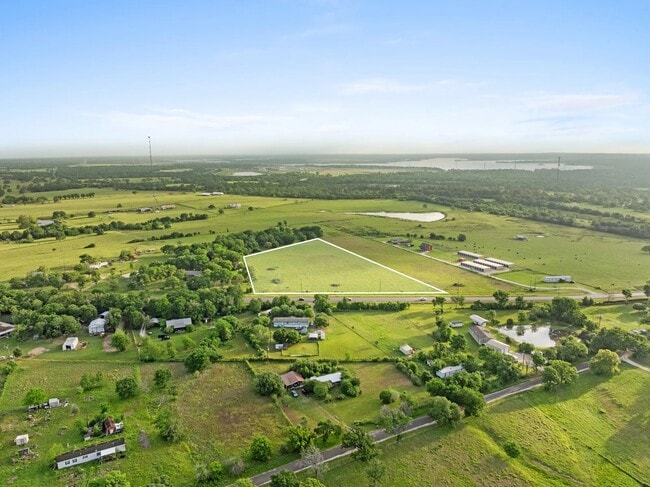
Property Record
Highway 30, Anderson, TX 77830

Property Detail
Highway 30
R46332
A0223 P GOODBREAD, TRACT 27-3, ACRES 5.941
Commercialnec
GRIMES
3
Texas
B and X Area of moderate flood hazard, usually the area between the limits of the 100-year and 500-year floods.
3-27
2024
5.94 AC
2025
Central Texas Area
180304
Other Market Areas
NEARBY LISTINGS FOR SALE OR LEASE
-
-
View all Anderson listings for sale on LoopNet.com
DEMOGRAPHICS near Highway 30
1 mile
3 mile
5 mile
2024 Total Population
230
565
1,714
2029 Population
264
650
1,973
Pop Growth 2024-2029
+ 14.78%
+ 15.04%
+ 15.11%
Average Age
44
44
45
2024 Total Households
92
225
676
HH Growth 2024-2029
+ 15.22%
+ 15.11%
+ 15.53%
Median Household Inc
$109,166
$95,138
$83,578
Avg Household Size
2.50
2.50
2.50
2024 Avg HH Vehicles
2.00
2.00
2.00
Median Home Value
$335,714
$320,000
$307,500
Median Year Built
1996
1997
1998
Nearby Places
Map Layers
Map Styles
 Street
 Aerial
Transit
 Traffic
 Biking
Places
Listings with unknown addresses are not visible on the map
- Restaurants
- Banks
- Shops
- Fitness
- Groceries
PUBLIC TRANSPORTATION
AIRPORT
Easterwood Field
Drive
Walk
Distance
Easterwood Field
38 min
22.6 mi
SALE & LEASE HISTORY
LISTING DATE
SALE/LEASE

Oct 21, 2021
For Sale
Aug 24, 2023
For Sale
Apr 29, 2025
For Sale
Nearby Properties
Address
Land Use
TOTAL SIZE
Lot Size
Zoning
Address
Land Use
TOTAL SIZE
Lot Size
Zoning
136.48 AC
Address
Land Use
TOTAL SIZE
Lot Size
Zoning
142,115 SF
76.68 AC
Address
Land Use
TOTAL SIZE
Lot Size
Zoning
1,987.10 AC
3
Address
Land Use
TOTAL SIZE
Lot Size
Zoning
318.65 AC
Address
Land Use
TOTAL SIZE
Lot Size
Zoning
483.80 AC
Address
Land Use
TOTAL SIZE
Lot Size
Zoning
88.60 AC
Address
Land Use
TOTAL SIZE
Lot Size
Zoning
15,565 SF
3.62 AC
Address
Land Use
TOTAL SIZE
Lot Size
Zoning
144 AC
Address
Land Use
TOTAL SIZE
Lot Size
Zoning
13,480 SF
19.95 AC
Address
Land Use
TOTAL SIZE
Lot Size
Zoning
19.68 AC
Address
Land Use
TOTAL SIZE
Lot Size
Zoning
15,560 SF
97.10 AC
3
Address
Land Use
TOTAL SIZE
Lot Size
Zoning
32,161 SF
31.56 AC
Address
Land Use
TOTAL SIZE
Lot Size
Zoning
28,725 SF
1.54 AC
Address
Land Use
TOTAL SIZE
Lot Size
Zoning
9,328 SF
17.47 AC
3
Address
Land Use
TOTAL SIZE
Lot Size
Zoning
21,734 SF
108.75 AC
3
Address
Land Use
TOTAL SIZE
Lot Size
Zoning
44.63 AC
Address
Land Use
TOTAL SIZE
Lot Size
Zoning
13,881 SF
5.94 AC
3
Address
Land Use
TOTAL SIZE
Lot Size
Zoning
3,160 SF
18.12 AC
3
Address
Land Use
TOTAL SIZE
Lot Size
Zoning
6,821 SF
15.52 AC
Address
Land Use
TOTAL SIZE
Lot Size
Zoning
7,105 SF
12.91 AC
Address
Land Use
TOTAL SIZE
Lot Size
Zoning
6,556 SF
15.99 AC
Address
Land Use
TOTAL SIZE
Lot Size
Zoning
4,956 SF
60 AC
3
Address
Land Use
TOTAL SIZE
Lot Size
Zoning
6,945 SF
14.60 AC
Address
Land Use
TOTAL SIZE
Lot Size
Zoning
7,824 SF
7.90 AC
3
Address
Land Use
TOTAL SIZE
Lot Size
Zoning
18.06 AC
Address
Land Use
TOTAL SIZE
Lot Size
Zoning
3,366 SF
6 AC
Address
Land Use
TOTAL SIZE
Lot Size
Zoning
12,222 SF
27.64 AC
Address
Land Use
TOTAL SIZE
Lot Size
Zoning
5,196 SF
195.04 AC
Address
Land Use
TOTAL SIZE
Lot Size
Zoning
4,372 SF
6.72 AC
Address
Land Use
TOTAL SIZE
Lot Size
Zoning
4,422 SF
19.98 AC
3
The World's #1 Commercial Real Estate Marketplace
Connect with us
© 2026 CoStar Group
The information above has been obtained from sources believed reliable. While we do not doubt its accuracy we have not verified it and make no guarantee, warranty or representation about it. It is your responsibility to independently confirm its accuracy and completeness. Any projections, opinions, assumptions, or estimates used are for example only and do not represent the current or future performance of the property. The value of this transaction to you depends on tax and other factors which should be evaluated by your tax, financial, and legal advisors. You and your advisors should conduct a careful, independent investigation of the property to determine to your satisfaction the suitability of the property for your needs.