Property Record
Highway 31, Arcadia, FL
Property Detail
Highway 31
Florida Central South Area
Stevenson Prairie Creek Unrec
Other Market Areas
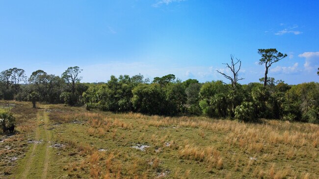
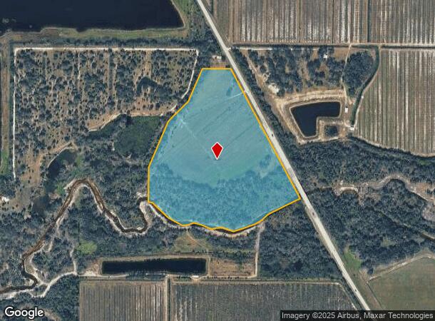
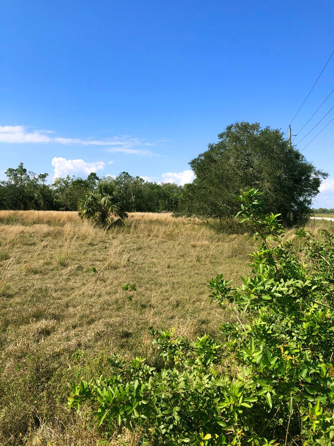
STEVENSON PRAIRIE CREEK UNREC MINOR PLAT LOT 1 MPDAF: COMM AT SE COR OF SEC 26 TWP 39S RNG 25E TH N 89D40M13S W ALG S LI OF SE1/4 OF SAID SEC 26 2642.59 FT TO S 1/4 COR OF SAID SEC 26 TH N 00D35M21S E ALG THE N-S 1/4 SEC LI OF SAID SEC 26 2420.43 FT
Arcadia, FL
DeSoto
26-39-25-0060-0000-0010
Florida
Pasture
1
2024
33.59 AC
2024
NEARBY LISTINGS FOR SALE OR LEASE
-
-
View all Arcadia listings for sale on LoopNet.com
DEMOGRAPHICS near Highway 31
1 mile
3 mile
5 mile
2024 Total Population
108
990
1,415
2029 Population
117
1,065
1,534
Pop Growth 2024-2029
+ 8.33%
+ 7.58%
+ 8.41%
Average Age
43
44
43
2024 Total Households
28
183
316
HH Growth 2024-2029
+ 10.71%
+ 10.93%
+ 11.39%
Median Household Inc
$55,000
$57,115
$56,224
Avg Household Size
2.80
2.70
2.70
2024 Avg HH Vehicles
2.00
3.00
2.00
Median Home Value
$250,000
$262,195
$264,843
Median Year Built
1994
1990
1992
Nearby Places
Map Layers
Map Styles
 Street
 Aerial
Transit
 Traffic
 Biking
Places
Listings with unknown addresses are not visible on the map
- Restaurants
- Banks
- Shops
- Fitness
- Groceries
PUBLIC TRANSPORTATION
AIRPORT
Punta Gorda
Drive
Walk
Distance
Punta Gorda
42 min
26.0 mi
Freight Ports
Port Manatee
Drive
Walk
Distance
Port Manatee
99 min
71.1 mi
Nearby Properties
Address
Land Use
TOTAL SIZE
Lot Size
Zoning
Address
Land Use
TOTAL SIZE
Lot Size
Zoning
1,280 SF
634 AC
A-10
Address
Land Use
TOTAL SIZE
Lot Size
Zoning
836 SF
1,658 AC
AG
Address
Land Use
TOTAL SIZE
Lot Size
Zoning
1,190 SF
539.80 AC
A-10
Address
Land Use
TOTAL SIZE
Lot Size
Zoning
426 SF
475.73 AC
AG
Address
Land Use
TOTAL SIZE
Lot Size
Zoning
548 AC
A-10
Address
Land Use
TOTAL SIZE
Lot Size
Zoning
12,495 SF
637.92 AC
A-10
Address
Land Use
TOTAL SIZE
Lot Size
Zoning
237 AC
A-10
Address
Land Use
TOTAL SIZE
Lot Size
Zoning
1,825 SF
640 AC
A-5
Address
Land Use
TOTAL SIZE
Lot Size
Zoning
729.20 AC
A-10
Address
Land Use
TOTAL SIZE
Lot Size
Zoning
609.30 AC
A-10
Address
Land Use
TOTAL SIZE
Lot Size
Zoning
19,550 SF
80 AC
A-10
Address
Land Use
TOTAL SIZE
Lot Size
Zoning
4,368 SF
4.98 AC
A-5
Address
Land Use
TOTAL SIZE
Lot Size
Zoning
623 AC
A-10
Address
Land Use
TOTAL SIZE
Lot Size
Zoning
160 AC
A-10
Address
Land Use
TOTAL SIZE
Lot Size
Zoning
3,488 SF
10.25 AC
A-10
Address
Land Use
TOTAL SIZE
Lot Size
Zoning
11,449 SF
40 AC
A-5
Address
Land Use
TOTAL SIZE
Lot Size
Zoning
3,276 SF
732 AC
A-10
Address
Land Use
TOTAL SIZE
Lot Size
Zoning
1,440 SF
10 AC
A-10
Address
Land Use
TOTAL SIZE
Lot Size
Zoning
66.13 AC
A-10
Address
Land Use
TOTAL SIZE
Lot Size
Zoning
80 AC
A-10
Address
Land Use
TOTAL SIZE
Lot Size
Zoning
2,718 SF
15 AC
A-5
Address
Land Use
TOTAL SIZE
Lot Size
Zoning
5,028 SF
25.85 AC
A-10
Address
Land Use
TOTAL SIZE
Lot Size
Zoning
1,080 SF
283 AC
A-10
Address
Land Use
TOTAL SIZE
Lot Size
Zoning
9,282 SF
40 AC
A-10
Address
Land Use
TOTAL SIZE
Lot Size
Zoning
100,924 SF
193.30 AC
A-10
Address
Land Use
TOTAL SIZE
Lot Size
Zoning
1,876 SF
15 AC
A-5
Address
Land Use
TOTAL SIZE
Lot Size
Zoning
3,856 SF
9.75 AC
A-10
Address
Land Use
TOTAL SIZE
Lot Size
Zoning
1,868 SF
14 AC
A-10
Address
Land Use
TOTAL SIZE
Lot Size
Zoning
7,386 SF
10 AC
A-10
Address
Land Use
TOTAL SIZE
Lot Size
Zoning
2,950 SF
4.96 AC
A-5
The World's #1 Commercial Real Estate Marketplace
Connect with us
© 2026 CoStar Group
The information above has been obtained from sources believed reliable. While we do not doubt its accuracy we have not verified it and make no guarantee, warranty or representation about it. It is your responsibility to independently confirm its accuracy and completeness. Any projections, opinions, assumptions, or estimates used are for example only and do not represent the current or future performance of the property. The value of this transaction to you depends on tax and other factors which should be evaluated by your tax, financial, and legal advisors. You and your advisors should conduct a careful, independent investigation of the property to determine to your satisfaction the suitability of the property for your needs.