Property Record
Highway 33, Manasquan, NJ 08736

NEARBY LISTINGS FOR SALE OR LEASE
Property Detail
Highway 33
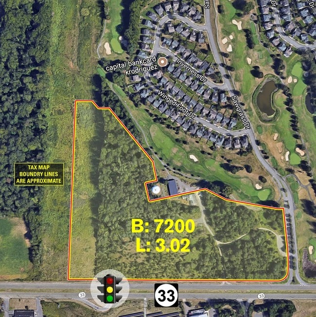
28-07200-0000-00003-02
Monmouth
Commercialofficeresidentialmixeduse
New Jersey
X
3.2
34023C0269F
24.46 AC
2024
Western Monmouth
2025
Northern New Jersey
808800
New York-Jersey City-White Plains, NY-NJ
DEMOGRAPHICS near Highway 33
1 Mile
3 Mile
5 Mile
2024 Total Population
2,292
16,688
56,236
2029 Population
2,260
16,579
55,852
Pop Growth 2024-2029
(1.40%)
(0.65%)
(0.68%)
Average Age
41
42
44
2024 Total Households
925
5,638
19,967
HH Growth 2024-2029
(1.62%)
(0.85%)
(0.82%)
Median Household Inc
$140,705
$149,644
$138,495
Avg Household Size
2.50
2.90
2.70
2024 Avg HH Vehicles
2.00
2.00
2.00
Median Home Value
$504,476
$600,244
$589,042
Median Year Built
2002
1998
1991
Nearby Places
Map Layers
Map Styles
 Street
 Aerial
- Restaurants
- Banks
- Shops
- Fitness
- Groceries
PUBLIC TRANSPORTATION
AIRPORT
Trenton Mercer
DRIVE
WALK
Distance
Trenton Mercer
44 min
29.4 mi
Freight Ports
New York Container Terminal
DRIVE
WALK
Distance
New York Container Terminal
53 min
34.6 mi
SALE & LEASE HISTORY
LISTING DATE
SALE/LEASE

Sep 24, 2016
For Sale
Aug 03, 2017
For Sale
Nearby Properties
Address
Land Use
TOTAL SIZE
Lot Size
Zoning
Address
Land Use
TOTAL SIZE
Lot Size
Zoning
3,060 SF
114.66 AC
PCD
Address
Land Use
TOTAL SIZE
Lot Size
Zoning
67.30 AC
PB
Address
Land Use
TOTAL SIZE
Lot Size
Zoning
220,000 SF
25.42 AC
PCD
Address
Land Use
TOTAL SIZE
Lot Size
Zoning
12.27 AC
PCD
Address
Land Use
TOTAL SIZE
Lot Size
Zoning
63.69 AC
HD
Address
Land Use
TOTAL SIZE
Lot Size
Zoning
9.28 AC
MF08
Address
Land Use
TOTAL SIZE
Lot Size
Zoning
1,980 SF
22.35 AC
Address
Land Use
TOTAL SIZE
Lot Size
Zoning
10.25 AC
PB
Address
Land Use
TOTAL SIZE
Lot Size
Zoning
56.30 AC
Address
Land Use
TOTAL SIZE
Lot Size
Zoning
7.87 AC
SEDA
Address
Land Use
TOTAL SIZE
Lot Size
Zoning
6.66 AC
CDFS
Address
Land Use
TOTAL SIZE
Lot Size
Zoning
9.63 AC
SED2W
Address
Land Use
TOTAL SIZE
Lot Size
Zoning
4.14 AC
9135
Address
Land Use
TOTAL SIZE
Lot Size
Zoning
389.96 AC
SF80
Address
Land Use
TOTAL SIZE
Lot Size
Zoning
4.30 AC
C3
Address
Land Use
TOTAL SIZE
Lot Size
Zoning
46,930 SF
12.39 AC
HC
Address
Land Use
TOTAL SIZE
Lot Size
Zoning
149.99 AC
GCRC
Address
Land Use
TOTAL SIZE
Lot Size
Zoning
9 AC
RAG4
Address
Land Use
TOTAL SIZE
Lot Size
Zoning
11.78 AC
HD
Address
Land Use
TOTAL SIZE
Lot Size
Zoning
23,697 SF
3.71 AC
R-LD
Address
Land Use
TOTAL SIZE
Lot Size
Zoning
204.29 AC
SF80
Address
Land Use
TOTAL SIZE
Lot Size
Zoning
10.60 AC
9151
Address
Land Use
TOTAL SIZE
Lot Size
Zoning
3,210 SF
18.60 AC
LBM
Address
Land Use
TOTAL SIZE
Lot Size
Zoning
2,816 SF
1 AC
SED2
Address
Land Use
TOTAL SIZE
Lot Size
Zoning
149.06 AC
RAG4
Address
Land Use
TOTAL SIZE
Lot Size
Zoning
9.56 AC
SED/
Address
Land Use
TOTAL SIZE
Lot Size
Zoning
2.35 AC
C-2
Address
Land Use
TOTAL SIZE
Lot Size
Zoning
23,619 SF
10.03 AC
4064
Address
Land Use
TOTAL SIZE
Lot Size
Zoning
3.60 AC
C3
Address
Land Use
TOTAL SIZE
Lot Size
Zoning
2.34 AC
C50
The World's #1 Commercial Real Estate Marketplace
Connect with us
© 2026 CoStar Group
The information above has been obtained from sources believed reliable. While we do not doubt its accuracy we have not verified it and make no guarantee, warranty or representation about it. It is your responsibility to independently confirm its accuracy and completeness. Any projections, opinions, assumptions, or estimates used are for example only and do not represent the current or future performance of the property. The value of this transaction to you depends on tax and other factors which should be evaluated by your tax, financial, and legal advisors. You and your advisors should conduct a careful, independent investigation of the property to determine to your satisfaction the suitability of the property for your needs.