Property Record
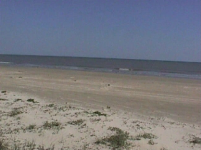
Highway 332, Surfside, TX 77541

Property Detail
Highway 332
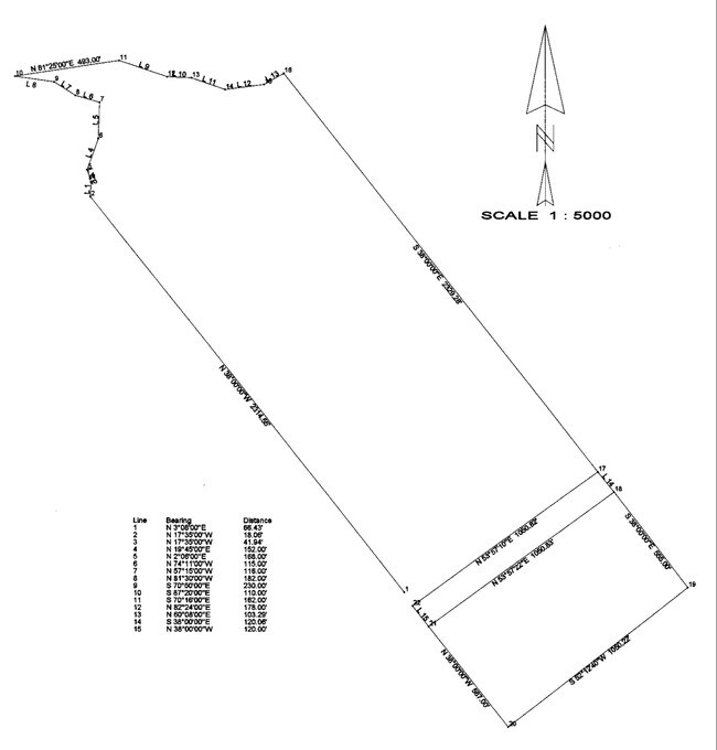
0051-0016-000
A0051 F J CALVIT BLOCK C-D-E ACRES 65.1 (SURFSIDE)
Agriculturalland
BRAZORIA
0014
Texas
AE The base floodplain where base flood elevations are provided. AE Zones are now used on new format FIRMs instead of A1-A30 Zones.
65.10 AC
0
South Hwy 35
2025
Houston
664200
Houston-Pasadena-The Woodlands, TX
NEARBY LISTINGS FOR SALE OR LEASE
-
-
View all Surfside listings for sale on LoopNet.com
DEMOGRAPHICS near Highway 332
1 mile
3 mile
5 mile
2025 Total Population
1,628
2,292
12,654
2030 Population
1,973
2,776
14,494
Pop Growth 2025-2030
+ 21.19%
+ 21.12%
+ 14.54%
Average Age
50
50
40
2025 Total Households
806
1,129
4,826
HH Growth 2025-2030
+ 21.46%
+ 21.52%
+ 15.42%
Median Household Inc
$84,848
$82,720
$52,117
Avg Household Size
2.00
2.00
2.60
2025 Avg HH Vehicles
2.00
2.00
2.00
Median Home Value
$345,412
$346,026
$223,384
Median Year Built
1986
1986
1978
Nearby Places
Map Layers
Map Styles
 Street
 Aerial
Layers
 Traffic
 Biking
Places
Listings with unknown addresses are not visible on the map
- Restaurants
- Banks
- Shops
- Fitness
- Groceries
SALE & LEASE HISTORY
LISTING DATE
SALE/LEASE

Sep 24, 2016
For Sale
Nearby Properties
Address
Land Use
TOTAL SIZE
Lot Size
Zoning
Address
Land Use
TOTAL SIZE
Lot Size
Zoning
Address
Land Use
TOTAL SIZE
Lot Size
Zoning
Address
Land Use
TOTAL SIZE
Lot Size
Zoning
10,390 SF
4.84 AC
Address
Land Use
TOTAL SIZE
Lot Size
Zoning
64,756 SF
26.71 AC
0200
Address
Land Use
TOTAL SIZE
Lot Size
Zoning
833.28 AC
0230
Address
Land Use
TOTAL SIZE
Lot Size
Zoning
930.22 AC
0035
Address
Land Use
TOTAL SIZE
Lot Size
Zoning
29,466 SF
11.19 AC
0261
Address
Land Use
TOTAL SIZE
Lot Size
Zoning
9,640 SF
3.41 AC
Address
Land Use
TOTAL SIZE
Lot Size
Zoning
517.62 AC
0029
Address
Land Use
TOTAL SIZE
Lot Size
Zoning
305.67 AC
Address
Land Use
TOTAL SIZE
Lot Size
Zoning
5,996 SF
0.27 AC
0014
Address
Land Use
TOTAL SIZE
Lot Size
Zoning
6,000 SF
10.77 AC
0200
Address
Land Use
TOTAL SIZE
Lot Size
Zoning
5,772 SF
4.45 AC
0061
Address
Land Use
TOTAL SIZE
Lot Size
Zoning
18,950 SF
17.77 AC
0165
Address
Land Use
TOTAL SIZE
Lot Size
Zoning
6,242 SF
0.19 AC
Address
Land Use
TOTAL SIZE
Lot Size
Zoning
11,712 SF
34.39 AC
Address
Land Use
TOTAL SIZE
Lot Size
Zoning
24.76 AC
0150
Address
Land Use
TOTAL SIZE
Lot Size
Zoning
9,202 SF
0.45 AC
Address
Land Use
TOTAL SIZE
Lot Size
Zoning
3,145 SF
2.25 AC
Address
Land Use
TOTAL SIZE
Lot Size
Zoning
3,350 SF
1.15 AC
0001
Address
Land Use
TOTAL SIZE
Lot Size
Zoning
15 AC
0630
Address
Land Use
TOTAL SIZE
Lot Size
Zoning
3,896 SF
0.63 AC
0010
Address
Land Use
TOTAL SIZE
Lot Size
Zoning
5,011 SF
0.45 AC
0038
Address
Land Use
TOTAL SIZE
Lot Size
Zoning
18,840 SF
1.70 AC
Address
Land Use
TOTAL SIZE
Lot Size
Zoning
11,900 SF
1.20 AC
0175
Address
Land Use
TOTAL SIZE
Lot Size
Zoning
6,410 SF
3.21 AC
Address
Land Use
TOTAL SIZE
Lot Size
Zoning
2,050 SF
0.44 AC
Address
Land Use
TOTAL SIZE
Lot Size
Zoning
1.86 AC
0025
Address
Land Use
TOTAL SIZE
Lot Size
Zoning
9,272 SF
0.27 AC
0053
The World's #1 Commercial Real Estate Marketplace
Connect with us
© 2026 CoStar Group
The information above has been obtained from sources believed reliable. While we do not doubt its accuracy we have not verified it and make no guarantee, warranty or representation about it. It is your responsibility to independently confirm its accuracy and completeness. Any projections, opinions, assumptions, or estimates used are for example only and do not represent the current or future performance of the property. The value of this transaction to you depends on tax and other factors which should be evaluated by your tax, financial, and legal advisors. You and your advisors should conduct a careful, independent investigation of the property to determine to your satisfaction the suitability of the property for your needs.